Poloniae, Lituaniae Q. Descriptio
Poloniae, Lituaniae Q. Descriptio | Gravures | ORTELIUS Abraham
Poloniae, Lituaniae Q. Descriptio
Poloniae, Lituaniae Q. Descriptio | Gravures | ORTELIUS Abraham
Mode de Paiement
- PayPal
- Carte bancaire
- Virement bancaire
- Pubblica amministrazione
- Carta del Docente
Détails
- Année
- 1595
- Lieu d'édition
- Anversa
- Format
- 490 X 375
- Graveurs
- ORTELIUS Abraham
Description
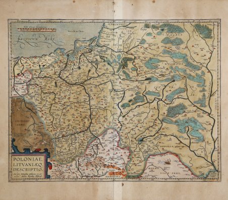
POLONIAE, | LITHVANIÆQ. | DESCRIPTIO. | "Auctore Wenceslao Godreccio; et cor:|rectore Andrea Pograbio Pilsnensi". In basso a sinstra: "Cum priuilegio | Imp. Regiæ etc. | decennali". Bella carta generale della Polonia e della Lituania. Esemplare della rara seconda lastra che compare nell'edizione successiva al 1595 del Theatrum Orbis Terrarum. Basata sulla mappa ormai perduta di Waclaw Grodecki & A. Pograbka. Mostra il regno polacco vicino ai suoi massimi limiti territoriali, estendendosi a sud fino ai confini del Mar Nero e ben dentro l'attuale Moldavia e Ucraina. La linea del fiume Dneiper all'estrema destra della mappa. Esemplare del secondo stato descritto da Van den Broecke; dal 1598 il nome "Tarasoucze" è aggiunto al simbolo della città vuota sul fiume "Prut". Inoltre, la doppia iscrizione di "Tubarcza" sul Dnjestr inferiore è scomparsa. Quella inferiore è stata sostituita da "Maiak". Dalla rara edizione italiana del Theatrum Orbis Terrarum stampata ad Anversa da Jean Baptiste Vrients nel 1608 e poi nel 1612. La carta di Ortelio si basa sull'opera di Grodecki (1558, 1562) e sulle emendazioni di Pograbka, soprattutto nella metà destra della lastra. La stessa carta di Grodecki è basata su Wapovsky 1526 (Karrow 56/17, p. 280-281, Meurer p. 159, 216). Nel 1595 questa lastra sostituisce l'altra carta di Ortelius con il titolo POLONIAE finitimarumque (1570), che ebbe due incrinature nel rame, in basso a destra, che ne impedirono l'uso. Il Theatrum Orbis Terrarum ' è considerato il primo vero “atlante” moderno. L’opera fu pubblicata in 7 lingue e 36 edizioni, per il quale – nel 1570 - Ortelius ottenne il ' privilegio, ovvero una sorta di diritto d'autore che impediva ad altri cartografi di pubblicare i propri lavori. Il ' Theatrum ' rappresentava il lavoro più avanzato del lavoro della descrizione cartografica. L’Ortelius vi raccolse il sapere geografico e cartografico del suo tempo, proponendo in 147 spettacolari tavole incise l’immagine più fedele del mondo allora conosciuto e, in alcune straordinarie “carte storiche”, regioni e itinerari tratti dalla letteratura, dalla mitologia, dalla tradizione. Ortelius fu anche il primo a citare le fonti, menzionando i nomi dei cartografi nel “catalogus auctorum”. Dal 1598 al 1612 le edizioni postume del ' Theatrum ' furono realizzate dal suo collaboratore Johannes Baptiste Vrients. Acquaforte, finemente colorata in epoca, minime ossidazioni, per il resto in buono stato di conservazione. Bibliografia Niewodniczanskiego, Image Polonuae, II, K7.10; Van den Broecke, Ort, 155; Van den Krogt AN: 1900:31B. ' POLONIAE, | LITHVANIÆQ. | DESCRIPTIO. | "Auctore Wenceslao Godreccio; et cor:|rectore Andrea Pograbio Pilsnensi". [A depiction of Poland and Lithuania by Wenceslav Godrecki and corrected by Andreas Pograbius of Pilsen]. Lower left: "Cum priuilegio | Imp. Regiæ etc. | decennali". Fine general map of Poland and Lithuania. The rare second plate appearing in the post-1595 edition of the Theatrum Orbis Terrarum. ' Based on the now-lost map of Waclaw Grodecki & A. Pograbka. Shows the Polish kingdom near its greatest territorial limits, stretching south to the borders of the Black Sea and well into present-day Moldova and Ukraine. The line of the Dneiper River at the extreme right of the map. Example of the second state described by Van den Broecke; from 1598 the name "Tarasoucze" is added to the blank town symbol on the river "Prut". Moreover, the double entry of "Tubarcza" on the lower Dnjestr has disappeared. The lower one has been replaced by "Maiak". From the rare Italian edition of ' Theatrum Orbis Terrarum ' printed in Antwerp by Jean Baptiste Vrients in 1608 and then in 1612. The Ortelius’ map is based on the work by Grodecki (1558, 1562) and emendations by Pograbka, mostly on the right half of the plate. Grodecki's map itself is based on Wapovsky 1526 (Karrow 56/17, p. 280-281, Meurer p. 159, 216). ' During 1595 this plate replaces the other Ortelius map which has the title POLONIAE finitimarumque (1570) and which incurred two cracks in the lower right prohibiting further usage. The ' Theatrum Orbis Terrarum is considered the first true modern "Atlas". The work was published in 7 languages and 36 editions, for which - in 1570 - Ortelius obtained the privilege, a kind of copyright that prevented other cartographers from publishing his works. The ' Theatrum ' represented the most advanced work of cartographic description. Ortelius collected in it the geographical and cartographic knowledge of his time, proposing in 147 spectacular engraved plates the most faithful image of the world then known and, in some extraordinary "historical maps", regions and routes taken from literature, mythology, tradition. Ortelius was also the first to cite sources, mentioning the names of cartographers in the "catalogus auctorum". From 1598 to 1612 the posthumous editions of the ' Theatrum ' were made by his collaborator Johannes Baptiste Vrients. Copper engraving, contemporary coloring, in good condition. Bibliografia Niewodniczanskiego, Image Polonuae, II, K7.10; Van den Broecke, Ort, 155; Van den Krogt AN: 1900:31B. Cfr.
