Pomeraniae, Wandalicae Regionis, Typ. & Livoniae Nova Descriptio & Ducatus Oswieczensis, et Zatoriensis, Descriptio.
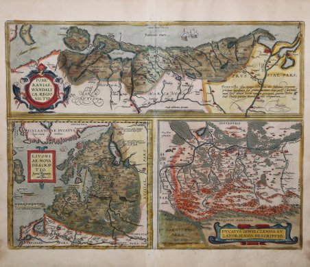
Pomeraniae, Wandalicae Regionis, Typ. & Livoniae Nova Descriptio & Ducatus Oswieczensis, et Zatoriensis, Descriptio.
Mode de Paiement
- PayPal
- Carte bancaire
- Virement bancaire
- Pubblica amministrazione
- Carta del Docente
Détails
- Année
- 1570
- Lieu d'édition
- Anversa
- Format
- 505 X 385
- Graveurs
- ORTELIUS Abraham
Description
Tre carte geografiche in un foglio, raffiguranti la Pomerania, la Lettonia e la Polonia meridionale. Mappa tratta dall'edizione italiana del 1608 del Theatrum Orbis Terrerum di Ortelius, che è considerato il primo vero “atlante” moderno. L’opera fu pubblicata in 7 lingue e 36 edizioni, per il quale – nel 1570 - Ortelius ottenne il ' privilegio, ovvero una sorta di diritto d'autore che impediva ad altri cartografi di pubblicare i propri lavori. Il ' Theatrum ' rappresentava il lavoro più avanzato del lavoro della descrizione cartografica. L’Ortelius vi raccolse il sapere geografico e cartografico del suo tempo, proponendo in 147 spettacolari tavole incise l’immagine più fedele del mondo allora conosciuto e, in alcune straordinarie “carte storiche”, regioni e itinerari tratti dalla letteratura, dalla mitologia, dalla tradizione. Ortelius fu anche il primo a citare le fonti, menzionando i nomi dei cartografi nel “catalogus auctorum”. Dal 1598 al 1612 le edizioni postume del ' Theatrum ' furono realizzate dal suo collaboratore Johannes Baptiste Vrients. Incisione in rame, finemente colorata a mano, in ottimo stato di conservazione. These maps of Pomerania, Livonia, and southern Poland are based on the cartography of Peter Artopaus; Marcus Ambrosius and Caspar Henneberger; and Stanislaw Porebski respectively. Three maps on one sheet, depicts complete Letland with the city Riga, Pommern ans little Poland with the city Wadowice. That map also shows the Baltic Sea coast from Rugen to Gdansk, the Baltic States of Estonia, Latvia and Lithuania, as well as parts of southern Poland north of the Carpathian Mountains.From Ortelius' Theatrum Orbis Therrarum, italian edition of 1608. On the back of the maps are descriptions of the regions. The ' Theatrum Orbis Terrarum ' is considered the first true modern "Atlas". The work was published in 7 languages and 36 editions, for which - in 1570 - Ortelius obtained the privilege, a kind of copyright that prevented other cartographers from publishing his works. The ' Theatrum ' represented the most advanced work of cartographic description. Ortelius collected in it the geographical and cartographic knowledge of his time, proposing in 147 spectacular engraved plates the most faithful image of the world then known and, in some extraordinary "historical maps", regions and routes taken from literature, mythology, tradition. Ortelius was also the first to cite sources, mentioning the names of cartographers in the "catalogus auctorum". From 1598 to 1612 the posthumous editions of the ' Theatrum ' were made by his collaborator Johannes Baptiste Vrients. Copper engraving, contemporary coloring, in good condition. Cfr. Van Broecke, Ortelius 158.