Provinciae, Regionis Galliae, vera exactissimaq. descriptio…
Provinciae, Regionis Galliae, vera exactissimaq. descriptio… | Gravures | HONDIUS Jodocus
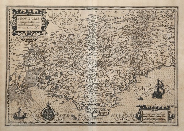

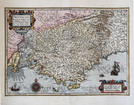
Provinciae, Regionis Galliae, vera exactissimaq. descriptio…
Provinciae, Regionis Galliae, vera exactissimaq. descriptio… | Gravures | HONDIUS Jodocus
Mode de Paiement
- PayPal
- Carte bancaire
- Virement bancaire
- Pubblica amministrazione
- Carta del Docente
Détails
- Année
- 1606
- Lieu d'édition
- Amsterdam
- Format
- 515 X 360
- Graveurs
- HONDIUS Jodocus
- Langues
- Italien
Description
Questa magnifica e decorative mappa della Provenza è basata sulla mappa di Pierre-Jean de Bompar’s del 1591. Intagliata per Jodocus Hondius dal noto incisore olandese Baptiste van Doetecum, che la decorò secondo il suo stile caratteristico, con accesi cartigli, un’elaborata rosa dei venti, velieri e mostri marini. La mappa copre l’area da Avignone al delta del Rodano fino a Saluzzo e Sanremo. La carta del Bompard è la “prima carta a stampa della Provenza, incisa da Giacomo Fornasieri per Pierre Jean de Bompar, giudice reale di Grasse, nel 1591. La carta viene realizzata per il duca di Savoia, Carlo Emanuele I (1562-1630), e doveva probabilmente avere un fine militare ed essere usata per l’invasione della Provenza. Questa mappa rappresenta infatti una preziosa fonte di informazioni, per la ricchezza e la novità dei toponimi riportati: alcuni villaggi e comuni compaiono per la prima volta su una mappa. Come sostiene Le Menn, il suo vero autore sarebbe però Jules-Raymond de Solier (circa 1530 - prima del 1595), un astronomo e naturalista provenzale poco noto, il primo scrittore della regione. La mappa firmata dal Bompar sarebbe quindi più antica del 1591; mostra, infatti, ancora il braccio medioevale di Passon sul fiume Rodano, che venne rimosso nel 1587 per dare inizio ai lavori del nuovo canale chiamato Vidange e che non appare su questa carta. Nell’opera non è indicato il luogo di stampa che, sulla base di altre incisioni del Fornasieri, potrebbe essere o Torino o Roma; la dedica al duca di Savoia lascia propendere per il capoluogo sabaudo, come già indicato in maniera dubitativa da Meurer. Tuttavia, non possiamo escludere che il LES TIGNES che introduce l’avviso ai lettori del Bompard sia il nome del piccolo villaggio sabaudo nelle alpi, nel quale in questo caso potrebbe essere stata pubblicata la stampa. La carta del Bompard fu la base della cartografia della regione per tutto il secolo successivo, replicata in tutti gli atlanti a partire dalla tavola inserita da Abraham Ortelius nel Theatrum Orbis Terrarum del 1594. Il solo esemplare noto dell’opera è quello conservato alla Bibliothèque Municipale di Grenoble” (cfr. Cartografia e Topografia Italiana del XVI secolo, pp. 990-993, tav. 383). Nel 1604, Jodocus Hondius (1563-1612) - probabilmente tramite Cornelis Claesz - acquistò le matrici in rame dell'Atlas sive cosmographicae meditationes de fabrica mundi di Gerard Mercator all’asta. Aggiunse circa 40 mappe, comprese nuove mappe dei continenti e importanti mappe regionali delle Americhe, prima di pubblicare una nuova edizione dell’opera, nel 1606, in concorrenza con il Theatrum Orbis Terrarum di Ortelius. Poiché molte delle mappe erano più aggiornate, la raccolta di Mercator & Hondius sostituì effettivamente il Theatrum di Ortelius. ' L’atlante del 1606 include tutte le 107 mappe dell’edizione del 1595, oltre a 37 nuove mappe, abilmente incise dallo stesso Hondius. La seconda edizione della raccolta seguì già nel 1607/08, mentre la prima edizione in un’altra lingua, il francese, fu messa sul mercato nel 1609. Apparentemente questa fu considerata come la terza edizione, perché nel 1611 apparve l'Editio Quarta, con un totale di 150 mappe. Dopo la morte di Jodocus Hondius (1612) la sua vedova e i suoi figli continuarono la stampa dell’atlante. Jodocus Junior ( o Jodocus II, 1594-1629) produsse diverse ristampe tra il 1613 e il 1619, sempre con le stesse 150 mappe; nel 1619 furono invece aggiunte sei nuove mappe. Dopo il 1620 la pubblicazione venne curata da Hendrick (Henricus) Hondius (1597-1651), il secondo figlio di Jodocus senior. Varie edizioni apparvero, nel 1623, 1628 e 1630. Hendrick fu il primo ad apportare dei veri cambiamenti: nell’edizione del 1628 firmò alcune mappe di Mercatore con il proprio nome. Nel 1630, quando probabilmente stava già collaborando con suo cognato Johannes Janssonius, aggiunse nove nuove carte. Incisione su rame, finemente colorata a m. This superb, decorative map of Provence was based on Pierre-Jean de Bompar's map of 1591. It was engraved by the famous Dutch copperplate engraver Baptista van Doetecum who embellished it in his distinctive style with bold cartouches, an elaborate compass rose, sailing ships and sea monsters. The map covers the region from Avignon and the Rhone delta to Saluzzo and San Remo in Italy. The Bompard map is the “first printed map of Provence, engraved by Giacomo Fornasieri for Pierre Jean de Bompar, royal judge of Grasse, in 1591. The map is made for the Duke of Savoy, Charles Emmanuel I (1562-1630), and was probably intended to have a military purpose and be used for the invasion of Provence. Indeed, this map is a valuable source of information because of the richness and novelty of the place names given: some villages and communes appear on a map for the first time. As Le Menn argues, however, its real author would be Jules-Raymond de Solier (ca. 1530-before 1595), a little-known Provençal astronomer and naturalist, the first writer on the region. The map signed by Bompar would therefore be older than 1591; it still shows, in fact, the medieval arm of Passon on the Rhone River, which was removed in 1587 to begin work on the new canal called Vidange and which does not appear on this map. The place of printing is not indicated in the work, which, on the basis of other engravings by Fornasieri, could be either Turin or Rome; the dedication to the Duke of Savoy leaves one leaning toward the Savoy capital, as Meurer has already dubiously indicated. However, we cannot rule out the possibility that the LES TIGNES that introduces the notice to Bompard's readers is the name of the small Savoyan village in the Alps, in which print may have been published in this case. Bompard's map was the basis for cartography of the region throughout the next century, replicated in all atlases since the plate inserted by Abraham Ortelius in the 1594 Theatrum Orbis Terrarum. The only known copy of the work is the one preserved at the Bibliothèque Municipale in Grenoble” (cfr. Cartografia e Topografia Italiana del XVI secolo, pp. 990-993, tav. 383). Map taken from the Atlas sive cosmographicae meditationes de fabrica mundi. In 1604, Jodocus Hondius (1563-1612) – probably trought Cornelis Claesz - bought the copperplates of Mercator’s Atlas sive cosmographicae meditationes de fabrica mundi at the auction of Gerard Jr.’s effects. He added about 40 maps, including new maps of the Continents and important regional maps of the Americas, before publishing a new edition of the Atlas, in 1606, in competition with Ortelius’ Theatrum Orbis Terrarum. As many of the maps were more up-to-date, the Mercator-Hondius Atlas effectively superseded Ortelius’ Theatrum. ' This atlas from 1606 include all 107 maps from the 1595 edition, as well as 37 new maps, skillfully engraved by Hondius, of various authors. The second edition of the Mercator-Hondius atlas followed as soon as 1607/08. The first edition in another language, French, was put on the market in 1609. Apparently this one was regarded as the third edition, because in 1611 ' Editio Quarta ' appeared with a total of 150 maps. After the death of Jodocus Hondius in 1612 his widow and sons continued the publication of the ' Atlas. ' For instance Jodocus Junior (1594-1629) produced several new editions of the ' Editio Quarta ' between 1613 and 1619, each with the same 150 maps. Finally in 1619 the last edition of this atlas followed, to which six new maps were added. After 1620 the publication of the ' Atlas ' was continued by Henricus Hondius (ca. 1596/97-1651), the second son of Jodocus senior. Various editions appeared, in 1623, 1628 and 1630. Henricus Hondius was the first to make some real changes: in the 1628 edition he provided some Mercator maps with his own name. In 1630, when he was probably already cooperating with his brother-in- law Johannes Janssonius, Henricus added nine new maps. Copperplate . Cfr. Koeman I, 4700:1A. Van der Krogt (Vol. I) #4700:1A; cfr. S. Bifolco/F. Ronca, Cartografia e Topografia Italiana del XVI secolo (2018) pp. 990-993, tav. 383; Almagià (1953): pp. 222; Le Menn (1998): pp. 3-28; Meurer (1991): pp. 117.
