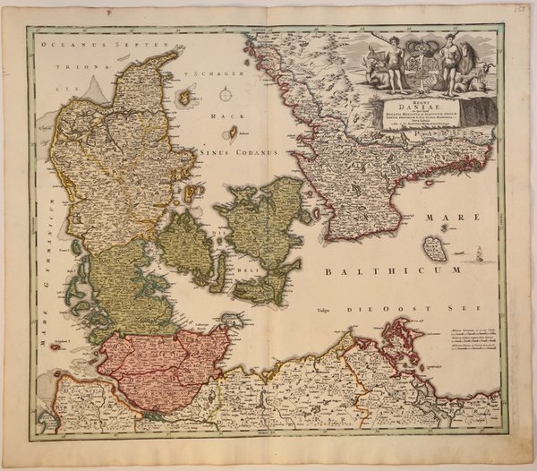
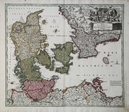
Regni Daniae in quo sund Ducatus Holsatia et Slesvicum Insulae, Danicae, Provinciae, Iustia, Scania Blekingia Nova Tabula
Regni Daniae in quo sund Ducatus Holsatia et Slesvicum Insulae, Danicae, Provinciae, Iustia, Scania Blekingia Nova Tabula | Gravures | HOMANN Johann Baptist

Regni Daniae in quo sund Ducatus Holsatia et Slesvicum Insulae, Danicae, Provinciae, Iustia, Scania Blekingia Nova Tabula
Regni Daniae in quo sund Ducatus Holsatia et Slesvicum Insulae, Danicae, Provinciae, Iustia, Scania Blekingia Nova Tabula | Gravures | HOMANN Johann Baptist
Mode de Paiement
- PayPal
- Carte bancaire
- Virement bancaire
- Pubblica amministrazione
- Carta del Docente
Détails
- Année
- 1716
- Lieu d'édition
- Norimberga
- Format
- 570 X 490
- Graveurs
- HOMANN Johann Baptist
Description
Bella e dettagliata carta geografica del Regno di Danimarca Danimarca, che mostra sia la parte insulare che quella peninsulare, nonché parte della Germania e della Svezia. Ricca e accurata la toponomastica, che riporta città, villaggi, strade, foreste, castelli e ponti. Grande cartiglio decorativo, con lo stemma reale danese e una scena pastorale. La carta fu realizzata da Homann per il suo Grosser Atlas. Johann Baptist Homann è stato un geografo e cartografo tedesco; nel 1702 fondò la sua casa editrice. Homann acquisì fama come uno dei principali cartografi tedeschi, e nel 1715 fu nominato geografo imperiale dall'imperatore Carlo VI. Nello stesso anno fu anche nominato membro dell'Accademia Prussiana delle Scienze a Berlino. Nel 1716 Homann pubblicò il suo capolavoro Grosser Atlas ueber die ganze Welt. Numerose mappe furono redatte in collaborazione con l'incisore Christoph Weigel. Homann morì a Norimberga nel 1724. Gli successe suo figlio Johann Christoph (1703-1730). L'azienda continuò dopo la sua morte come azienda degli eredi Homann, gestita da Johann Michael Franz e Johann Georg Ebersberger. Dopo successivi cambiamenti nella gestione, l'azienda si sciolse nel 1852. ' Incisione in rame, finemente colorata a mano, in ottime condizioni. A beautifully detailed map of Denmark. Depicts both insular and peninsular Denmark along with parts of Germany and Sweden. The map notes fortified cities, villages, roads, bridges, forests, castles and topography. The elaborate title cartouche in the upper right quadrant features two bearded mean bearing clubs, an assortment of pastoral animals, and the Danish royal crest. The map was made by Homann for his Grosser Atlas. Johann Baptist Homann was a German geographer and cartographer; in 1702 he founded his own publishing house. Homann acquired renown as a leading German cartographer, and in 1715 was appointed Imperial Geographer by Emperor Charles VI. In the same year he was also named a member of the Prussian Academy of Sciences in Berlin. In 1716 Homann published his masterpiece Grosser Atlas ueber die ganze Welt; numerous maps were drawn up in cooperation with the engraver Christoph Weigel the Elder. Homann died in Nuremberg in 1724 and was succeeded by his son Johann Christoph (1703-1730). The company carried on upon his death as Homann heirs company, managed by Johann Michael Franz and Johann Georg Ebersberger. After subsequent changes in management the company folded in 1852. ' Etching with fine original colour, good condition. Cfr.
