Romanum Territorium
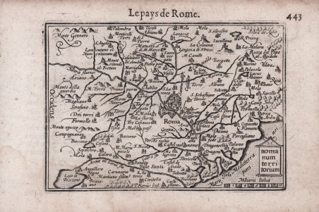
Romanum Territorium
Mode de Paiement
- PayPal
- Carte bancaire
- Virement bancaire
- Pubblica amministrazione
- Carta del Docente
Détails
- Année
- 1598
- Lieu d'édition
- Amsterdam
- Format
- 125 X 90
- Graveurs
- KAERIUS Pieter van den Keere
Description
Rara carta geografica per la prima volta pubblicata nel "Caert-thresoor" di Barent Langenes edito ad Amstredam da Cornelis Claesz nel 1598. Esemplare dalla successiva ristampa con testo francese del 1599, denominata "Thrésor de chartes" edita sempre da Cornelis Claesz nel 1599. Alla fine del XVI secolo il più famoso e commercializzato atlante “tascabile” era l’Epitome ' di Abraham Ortelius. Nel 1598 gli editori Barent Langenes e Cornelis Claesz diedero alle stampe una raccolta di superiore qualità. Le lastre sono affidate ad abili intagliatori quali Pieter Kaerius e Jodocus Hondius. ' Acquaforte, leggera gora d'acqua in basso a destra, per il resto in ottimo stato di conservazione. Bibliografia King, ' Miniature Antique Maps, ' pp. 80-82. Rare map first published in Barent Langenes' "Caert-thresoor" published in Amstredam by Cornelis Claesz in 1598. Example from the later 1599 reprint with French text called "Thrésor de chartes" also published by Cornelis Claesz in 1599. At the end of the 16th century the most famous and marketed "pocket" atlas was Abraham Ortelius' ' Epitome. In 1598 the publishers Barent Langenes and Cornelis Claesz brought to print a collection of superior quality. The plates are entrusted to skilled engravers such as Pieter Kaerius and Jodocus Hondius. Copperplate engraving, a light waterstain at the lower right corner, otherwise in excellent condition. ' Bibliografia King, ' Miniature Antique Maps, ' pp. 80-82. Cfr.