Serenissimae Reipublicae Genuensis Ducatus et Dominii Nova Descriptio
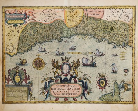
Serenissimae Reipublicae Genuensis Ducatus et Dominii Nova Descriptio
Mode de Paiement
- PayPal
- Carte bancaire
- Virement bancaire
- Pubblica amministrazione
- Carta del Docente
Détails
- Année
- 1608
- Lieu d'édition
- Amsterdam
- Format
- 540 X 395
- Graveurs
- VRIENTS Johannes Baptiste
Description
Titolo nel grande cartiglio decorato nel mare: SERENISSIMÆ | REIPVBLICÆ GENVENSIS | DVCATVS ET DOMINII | NOVA DESCRIPTIO. Nel cartiglio in basso a sinistra troviamo la dedica: MOLTO ILL.RE SIG.R ANTONIO SIVORI | GENTILHUOMO GENOVESE. | Conuiene à v.s. piu che à nessum 'altro la | dedicatione della LIGVRIA, come quella | dalla quale ne ho hauuto il lume, & | come affettionata meritamente alla | sua Patria, pero à V.S. humilmente la | dedico, in Anuersa a 29 Agosto 1608. | D.V.S. Molto Ill.re | aff.mo Ser.e | Gio. Bat.ta Vrints. Si tratta di un bellissimo esemplare della carta della Repubblica di Genova di Jan Baptista Vrients, aggiunta al Theatrum Orbis Terrarum di Ortelio nel 1608. Tratto dalla rara edizione italiana del Theatrum Orbis Terrarum stampata ad Anversa da Jean Baptiste Vrients nel 1608 e poi nel 1612. Secondo Peter Meurer, la carta è una compilazione delle mappe della Liguria di levante e di ponente di Giovanni Antonio Magini del 1597. Si tratterebbe delle sue rarissime carte in prima edizione, emesse separatamente e non quelle che si trovano poi nell’Italia del figlio Fabio Magini (1620): la "Liguria overo Riviera di Genova Occidentale" e la "Liguria overo Riviera di Genova di Levante". Tuttavia, Vrients non le riprese fedelmente; la linea di costa presentata è significativamente meno concava di quella indicata (con precisione) nelle carte di Magini. Sembra che Vrients abbia voluto che la carta fosse visivamente più coerente con la carta del Piemonte di Ortelius, che era conforme alle autorevoli carte del Gastaldi della metà del XVI secolo. I dettagli specifici lungo la costa di Ortelius/Gastaldi, come baie, fiumi e promontori, sono invece stati sostituiti con quelli tratti dall'opera di Magini del 1597. La carta riflette un periodo di grande potere finanziario e politico per la Repubblica di Genova. Nel corso del XVI secolo, molte famiglie aristocratiche genovesi accumularono enormi fortune attraverso le banche e il commercio, compresa la schiavitù, in gran parte legata all'esplorazione e allo sfruttamento del Nuovo Mondo. L'Impero spagnolo, in particolare, si affidò a finanziatori genovesi nella seconda metà del XVI secolo e nel primo quarto del XVII. La nobiltà mercantile genovese divenne di conseguenza mecenate delle arti - un esempio potrebbe essere il dedicatario della presente mappa, "Sigr. Antonioto Sivori" (un "Gentiluomo genovese" il cui nome sembra non essere sopravvissuto in nessun altro documento storico se non in questa dedica). La dedica a Sivori, in effetti, è superba: un basamento sormontato dalle armi della famiglia e circondato da un motivo a fasce e da foglie dai colori vivaci, che presenta una sirena coronata da vongole e zampe di granchio. Il centro è dominato da un audace cartiglio del titolo, sormontato dalle armi genovesi e da due grifoni. Oltre alla costa ligure, la parte settentrionale dell'isola di Corsica è inclusa in basso a destra. È accompagnata dalla "testa di moro" delle armate corse. Il mare è inciso con un motivo a righe, linee lossodromiche e una superba rosa dei venti. Il mare ligure è solcato da sei grandi galee genovesi e da altri due velieri. Due mostri marini si aggirano sulle coste di Nizza e della Corsica. Questa carta fu incisa nel 1608, da o per conto di Jan Baptista Vrients, per essere inserita nel Theatrum di Ortelius, che Vrients continuò a pubblicare come esecutore testamentario di Ortelius. Pertanto, è apparsa solo nelle quattro edizioni finali dell'atlante di Ortelius ed è di conseguenza una delle mappe più scarse tra quelle che compaiono in quell'opera. Costituisce l’apice della cartografia decorativa e si colloca tra le mappe più sontuosamente incise. Come noto, gli atlanti di Ortelius stampati da Vrients godevano di una colorazione a mano di altissima qualità e la presente carta ne è un esempio: la colorazione dei cartigli, delle rose delle bussole e delle navi è particolarmente ricca. Johannes Baptista Vrients (155. Title in the cartouche at the center: SERENISSIMÆ | REIPVBLICÆ GENVENSIS | DVCATVS ET DOMINII | NOVA DESCRIPTIO. Bottom left: MOLTO ILL.RE SIG.R ANTONIO SIVORI | GENTILHUOMO GENOVESE. | Conuiene à v.s. piu che à nessum 'altro la | dedicatione della LIGVRIA, come quella | dalla quale ne ho hauuto il lume, & | come affettionata meritamente alla | sua Patria, pero à V.S. humilmente la | dedico, in Anuersa a 29 Agosto 1608. | D.V.S. Molto Ill.re | aff.mo Ser.e | Gio. Bat.ta Vrints. This is a beautiful example of the map of the Republic of Genoa by Jan Baptista Vrients, added to Ortelius' Theatrum Orbis Terrarum in 1608. Taken from the rare Italian edition of Theatrum Orbis Terrarum printed in Antwerp by Jean Baptiste Vrients in 1608 and again in 1612. According to Peter Meurer, the map is a compilation of Giovanni Antonio Magini's 1597 maps of eastern and western Liguria. These would be his very rare first edition maps, issued separately and not those later found in his son Fabio Magini's Italia (1620): the "Liguria overo Riviera di Genova Occidentale" and the "Liguria overo Riviera di Genova di Levante." However, Vrients did not faithfully capture them; the coastline presented is significantly less concave than that shown accurately in Magini's maps. It seems that Vrients wanted the map to be visually more consistent with Ortelius' map of Piedmont, which was in accordance with Gastaldi's authoritative mid-sixteenth-century maps. Specific details along the Ortelius/Gastaldi coastline, such as bays, rivers and headlands, were instead replaced with those from Magini's 1597 work. The map reflects a period of great financial and political power for the Republic of Genoa. During the 16th century, many Genoese aristocratic families amassed enormous fortunes through banking and trade, largely related to the exploration and exploitation of the New World. The Spanish Empire, in particular, relied on Genoese financiers in the second half of the 16th century and the first quarter of the 17th. The Genoese merchant nobility consequently became patrons of the arts-an example might be the dedicatee of the present map, "Sigr. Antonioto Sivori" (a "Genoese Gentleman" whose name seems not to have survived in any other historical document but this dedication). Indeed, the dedication to Sivori is superb: a plinth surmounted by the family arms and surrounded by a banded motif and brightly colored leaves, featuring a mermaid crowned with clams and crab legs. The center is dominated by a bold title cartouche, surmounted by the Genoese arms and two griffins. In addition to the Ligurian coast, the northern part of the island of Corsica is included at lower right. It is accompanied by the "Moorhead" of the Corsican armies. The sea is engraved with a striped pattern, rhumb lines and a superb compass rose. The Ligurian sea is sailed by six large Genoese galleys and two other sailing ships. Two sea monsters roam the coasts of Nice and Corsica. This map was engraved in 1608, by or for Jan Baptista Vrients, for inclusion in Ortelius' Theatrum, which Vrients continued to publish as Ortelius' executor. Therefore, it appeared only in the final four editions of Ortelius' atlas and is consequently one of the scarcest maps among those appearing in that work. It constitutes the pinnacle of decorative cartography and ranks among the most lavishly engraved maps. As is well known, Ortelius' atlases printed by Vrients enjoyed the highest quality hand coloring, and the present map is an example of this: the coloring of the cartouches, compass roses, and ships is particularly rich. Johannes Baptista Vrients (1552-1612) was a Flemish engraver, publisher and cartographer. Not much is known about his early life, but it is assumed that he grew up as an apprentice among the cartographers of Antwerp, where the guild appointed him master in 1575. In the 1590s he executed maps of the world for Plancius and Linschoten. In 1600 he became executor of Ortelius' will . Cfr.