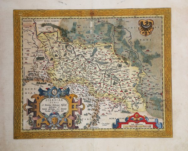
Silesiae Typus A Martino Helwigio Sissense descriptus. Et Nobili doctoque viro Domino Nicolao Rhedingero ded.
Silesiae Typus A Martino Helwigio Sissense descriptus. Et Nobili doctoque viro Domino Nicolao Rhedingero ded.
Mode de Paiement
- PayPal
- Carte bancaire
- Virement bancaire
- Pubblica amministrazione
- Carta del Docente
Détails
- Année
- 1595
- Lieu d'édition
- Anversa
- Format
- 425 X 355
- Graveurs
- ORTELIUS Abraham
- Description
- M. Van den Broecke "Ortelius Atlas Maps" (2011), n. 103.
Description
La mappa è basata sulla carta di Martin Helwig (1516-1574). Helwig era un matematico esperto, linguista e geografo classico, che divenne il rettore della scuola di Santa Maria Magdalena a Breslavia (oggi Breslavia, in Polonia), nel 1552. Helwig produsse la prima mappa in legno della Slesia fatta sulla base di indagini raccolte localmente, pubblicandola nel 1561 con il titolo di "Silesiae Typus" e dedicandola la Nicolaus II Rehdiger, ricco mercante, banchiere, filantropo, governatore e patrono della Slesia, patrocinatore della mappa. Carta tratta dal ' Theatrum Orbis Terrarum ' e che è considerato il primo vero “atlante” moderno. L’opera fu pubblicata in 7 lingue e 36 edizioni, per il quale – nel 1570 - Ortelius ottenne il ' privilegio, ovvero una sorta di diritto d'autore che impediva ad altri cartografi di pubblicare i propri lavori. Il ' Theatrum ' rappresentava il lavoro più avanzato del lavoro della descrizione cartografica. L’Ortelius vi raccolse il sapere geografico e cartografico del suo tempo, proponendo in 147 spettacolari tavole incise l’immagine più fedele del mondo allora conosciuto e, in alcune straordinarie “carte storiche”, regioni e itinerari tratti dalla letteratura, dalla mitologia, dalla tradizione. Ortelius fu anche il primo a citare le fonti, menzionando i nomi dei cartografi nel “catalogus auctorum”. Dal 1598 al 1612 le edizioni postume del ' Theatrum ' furono realizzate dal suo collaboratore Johannes Baptiste Vrients. Incisione in rame, eccellente coloritura coeva, in ottimo stato di conservazione. Revised edition of Ortelius' map of Silesia, which has been enlarged and embellished with a much more elaborate cartoche and military scale. Taken from " Thetarum Orbis Terrarum". Spanish edition of 1612. Shows the region from Olomunz and Crackaw in the south to Krossen and Syratz and Kails in the North, centered on Breslaw and Oppelen. Prague also appears at the bottom of the map.The map is based upon an extremely rare map by Martin Helwig (1516-1574). Helwig was a trained mathematician, classical linguist and geographer, who became the Rector of St. Maria Magdalena School in Breslau (now Wroc?aw, in Poland), in 1552. Helwig produced the first woodcut map of Silesia made on the basis of locally collected surveys and data which he published in 1561, under the title Silesiae Typus. Helwig dedicated the map to Nicolaus II. Rehdiger, a wealthy Silesian merchant, banker, philanthropist, governor and patron of the principality of Breslau (Wroc?aw), who sponsored the map. Martin Helwig's map went on to receive acclaim in a public writing by Caspar Peucer, an eminent German scholar at the University of Wittenberg, ultimately receiving the notice of Ortelius, who incorporated the map into the ' Theatrum Orbis Terrarum, which is considered the first true modern "Atlas". The work was published in 7 languages and 36 editions, for which - in 1570 - Ortelius obtained the privilege, a kind of copyright that prevented other cartographers from publishing his works. The ' Theatrum ' represented the most advanced work of cartographic description. Ortelius collected in it the geographical and cartographic knowledge of his time, proposing in 147 spectacular engraved plates the most faithful image of the world then known and, in some extraordinary "historical maps", regions and routes taken from literature, mythology, tradition. Ortelius was also the first to cite sources, mentioning the names of cartographers in the "catalogus auctorum". From 1598 to 1612 the posthumous editions of the ' Theatrum ' were made by his collaborator Johannes Baptiste Vrients. Copper engraving, contemporary coloring, in good condition. Cfr. M. Van den Broecke "Ortelius Atlas Maps" (2011), n. 103.