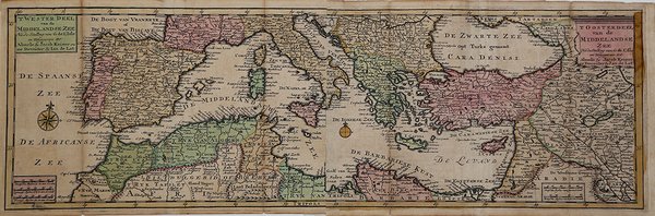
'T Wester Deel van de Middelandse Zee & 'T Oosterdeel van de Middelandse Zee
'T Wester Deel van de Middelandse Zee & 'T Oosterdeel van de Middelandse Zee
Mode de Paiement
- PayPal
- Carte bancaire
- Virement bancaire
- Pubblica amministrazione
- Carta del Docente
Détails
- Année
- 1747
- Lieu d'édition
- Deventer
- Format
- 460 X 175
- Graveurs
- LAT Jan de
- Description
- Cfr. C. Koeman, Atlas Neerlandici, LAT 7.
Description
Acquaforte, stampata su due fogli, coloritua coeva, in buono stato di conservazione.Carta nautica del Mediterraneo in due fogli, tratta dal raro "Atlas Portatif tres exact on livre de cartes geographiques. Weerelds Hand-Atlas" di Jan de LAT e Jacob KEIZER (Deventer e Almelo: 1747). Si tratta di un atlante tascabile che contiene 34 carte, tutte ripiegate, che derivano da G. de L'Isle.De Lat era uno dei pochi commercianti ed editori olandesi che non aveva sede in Amsterdam. Jacob Keizer era incisore e cartografo, attivo nella prima metà del XVIII secolo. Lavorava prima in Russi a e poi ad Almelo. Two sheets map of the Mediterranea Sea taken from the "Atlas Portatif tres exact on livre de cartes geographiques. Weerelds Hand-Atlas" by Jan de LAT and Jacob KEIZER (Deventer and Almelo: 1747). A rare pocket travelling atlas issued in Holland for the Dutch and French markets; including several maps of the world, the continents and Europe, based on de L'Isle's work. De Lat was one of the few booksellers outside Amsterdam who published maps and atlases, working at Deventer 1734-1750, and using as his engraver Jacob Keyzer of Almelo. Cf. Koeman Lat 7.Jacob Keizer was a Dutch engraver and cartographer active in the first half of the 18th century. Little is known of his life, but it is assumed that he was active in Russia and Amsterdam, and later Almelo. Cfr. Cfr. C. Koeman, Atlas Neerlandici, LAT 7.