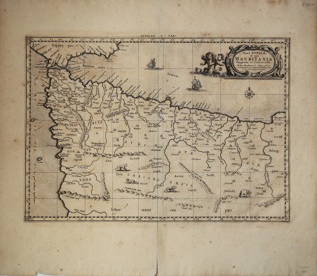
Tab.I Africae, in qua Mauritania Tingitana et Caesariensis…
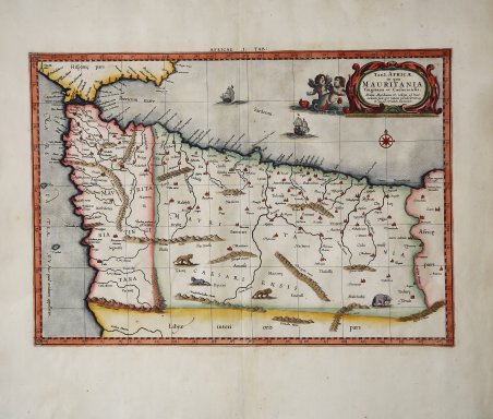
Tab.I Africae, in qua Mauritania Tingitana et Caesariensis…
Mode de Paiement
- PayPal
- Carte bancaire
- Virement bancaire
- Pubblica amministrazione
- Carta del Docente
Détails
- Année
- 1695
- Lieu d'édition
- Amsterdam
- Format
- 470 X 330
- Graveurs
- MERCATOR (Kremer) Gerard
- Langues
- Italien
Description
Mappa basata sul lavoro di Tolomeo; copre l'Africa nord-occidentale compreso il Marocco e la Tunisia, la costa contigua della Spagna e le Isole Baleari. All'estremità meridionale della Spagna si trovano le Colonne di Ercole. È raffigurato gran parte dell'angolo nord-occidentale dell'Africa, inclusa la maggior parte se non tutto il Marocco moderno e gran parte dell'Algeria. Vengono mostrate le grandi montagne dell'Atlante e altre catene montuose insieme a numerosi sistemi fluviali. Le città e i porti noti sono denominati, così come le isole a ovest del Marocco. La mappa viene originalmente preparata per illustrare il ' Cl. Ptolemaei Alexandrini, Geographiae Libri Octo, ' pubblicato prima a Colonia da Gottfried von Kempen (1578), ristampato dallo stesso editore nel 1584 (Van der Krogt 1, 502) e poi da Isaac Elsevier per il ' Theatrum Geographiae veteris ' di Petrus Bertius (Leyden 1618). Di tutte le edizioni di Tolomeo, quella di Gerard Kremer (Mercatore), pubblicata nel 1578, e forse tecnicamente la più bella. A questo punto la ' Geografia ' di Tolomeo perdeva pero ogni pretesa di “attualità”, laddove lo scopo di Mercatore era quello di produrre un atlante del mondo classico che servisse da complemento al suo atlante moderno (per tale ragione egli aveva tentato di recuperare la forma originale dell’atlante tolemaico, scartandone le moderne accrezioni). L’opera è celebre anche per la sua longevità, poiché le lastre originali risultavano ancora in uso nel 1730, oltre centocinquanta anni dopo la loro incisione. Esemplare tratto dalla ' Tabulae geographicae Cl: Ptolemei ' di François Halma, stampata tra Utrecht, Amsterdam e Leida nel 1695, 1698, 1704 (2 tirature) e 1730.Le lastre sono emendate e i cartigli completamenti cambiati; più piccoli e realizzati sopra i precedenti – abrasi – lasciando ampie aree bianche sulla stampa. Acquaforte, finemente colorata a mano, in buone condizioni. Map based on the work of Ptolemy; covers northwestern Africa including Morocco and Tunisia, the contiguous coast of Spain and the Balearic Islands. At the southernmost tip of Spain are the Pillars of Heracles at the eastern end of the Strait of Gibraltar, created, according to one legend by Hercules when he stamped his foot there. Much of the northwestern corner of Africa is depicted, including most if not all of modern-day Morocco, and much of Algeria. The great Atlas Mountains and other mountain ranges along with numerous rivers systems are shown. Known cities and ports of the day are named, as are islands due west of Morocco. ' Originally prepared for the ' Cl. Ptolemaei Alexandrini, Geographiae Libri Octo, ' first published in Cologne by Gottfried von Kempen (1578) and then reprinted by the same publisher in 1584 (Van der Krogt 1, 502) and then by Isaac Elsevier for the Petrus Bertius’ ' Theatrum Geographiae veteris ' (Leyden 1618). Mercator's interpretation of the 28 Ptolemaic text was possibly one of the truest undertaken up until that time. He had spent 13 years researching, drawing and engraving the maps at much commercial sacrifice to himself, having seen Ortelius's ' Theatrum ' and De Jodes ' Speculum ' published, to become both technical and commercial successes. In later life he devoted himself to his edition of the maps in Ptolemy's ' Geographia, reproduced in his own engraving as nearly as possible in their original form. The work is also famous for its longevity, since the original plates were still in use in 1730, over one hundred and fifty years after their engraving. Example taken from the ' Tabulae geographicae Cl: Ptolemei ' by François Halma, printed between Utrecht, Amsterdam and Leiden in 1695, 1698, 1704 (2 printings) and 1730. The plates are amended and the cartouches completely changed; smaller and made over the previous ones - erased - leaving large white areas on the print. Copperplate with fine later hand colour, good condition. Cfr.