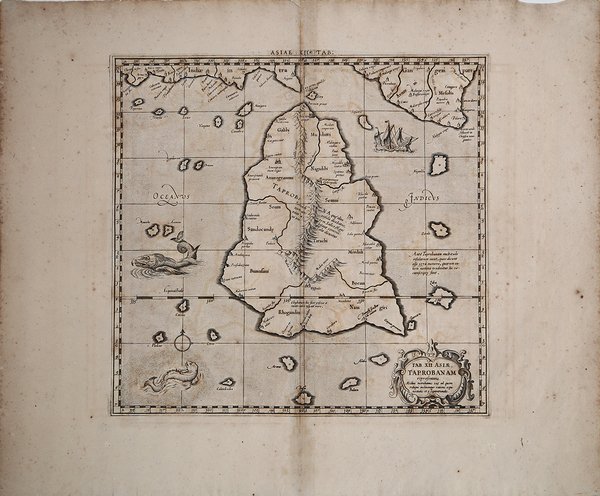
Esemplare finemente colorato della carta di Mercator di ' Taprobana, l'isola di Ceylon, talvolta confusa con Sumatra nelle prime mappe. Nell'antichità lo Sri Lanka era conosciuto con diversi nomi: Tolomeo lo chiamava ' Taprobana, ' gli arabi ' Serendib, i portoghesi ' Ceilo ' e gli inglesi ' Ceylon. Situato al centro di numerose rotte commerciali attraverso l'Oceano Indiano, l’odierno Sri Lanka è sempre stato un importante collegamento commerciale tra est e ovest. In quanto grande esportatore di cannella, i commercianti arabi e cinesi frequentavano l'isola fin dai tempi più antichi ed era una tappa importante per i mercanti sulla rotta marittima tra Asia ed Europa. Tra i cartografi medievali esisteva una grande confusione sull'identità delle isole di Taprobana e Sumatra, dovuta principalmente alle descrizioni dei testi antichi che affermavano che Taprobana era l'isola più grande del mondo. Questa affermazione fu poi contraddetta da Marco Polo nel suo ' Il Milione, in cui affermava che era ' Giava Minore ' (Sumatra) ad essere in realtà l'isola più grande. Poiché Sumatra era praticamente sconosciuta alla maggior parte dei cartografi medievali, la loro preoccupazione principale era la collocazione di Taprobana sulle mappe. Invariabilmente era posizionata in modo errato al largo della costa sud-orientale dell'Arabia, ma quando alla fine del XIII secolo furono resi noti i resoconti di Marco Polo, i limiti orientali dell'Oceano Indiano si ampliarono notevolmente e la questione dell'identità delle isole divenne più critica per i cartografi. I portoghesi arrivarono sull'isola nel 1505 e nel 1518 avevano costruito un forte a Colombo, consentendo loro di controllare le aree costiere strategiche che avevano precedentemente conquistato. Una volta copiate le informazioni e le carte portoghesi, la posizione di Ceylon e la confusione con Sumatra furono corrette. Tuttavia, alcuni studiosi ritengono che sia in realtà una rappresentazione dell'isola di Sumatra. Le isole circostanti raffigurate, sono rappresentate nella posizione delle odierne Nias, Enggano e Mentawis. La terra nell'angolo in alto a destra corrisponde alla Malesia; diverse città e villaggi si trovano collocati vicino alle attuali città di Lampung, Medan, Sibolga e Banda Aceh. Si trovano anche montagne e corsi d'acqua, anch'essi molto vicini all’attuale rappresentazione idrografica di Sumatra. ' La mappa è originalmente preparata per illustrare il ' Cl. Ptolemaei Alexandrini, Geographiae Libri Octo, ' pubblicato prima a Colonia da Gottfried von Kempen (1578), ristampato dallo stesso editore nel 1584 (Van der Krogt 1, 502) e poi da Isaac Elsevier per il ' Theatrum Geographiae veteris ' di Petrus Bertius (Leyden 1618). Di tutte le edizioni di Tolomeo, quella di Gerard Kremer (Mercatore), pubblicata nel 1578, e forse tecnicamente la più bella. A questo punto la ' Geografia ' di Tolomeo perdeva pero ogni pretesa di “attualità”, laddove lo scopo di Mercatore era quello di produrre un atlante del mondo classico che servisse da complemento al suo atlante moderno (per tale ragione egli aveva tentato di recuperare la forma originale dell’atlante tolemaico, scartandone le moderne accrezioni). L’opera è celebre anche per la sua longevità, poiché le lastre originali risultavano ancora in uso nel 1730, oltre centocinquanta anni dopo la loro incisione. Esemplare tratto dalla ' Tabulae geographicae Cl: Ptolemei ' di François Halma, stampata tra Utrecht, Amsterdam e Leida nel 1695, 1698, 1704 (2 tirature) e 1730.Le lastre sono emendate e i cartigli completamenti cambiati; più piccoli e realizzati sopra i precedenti – abrasi – lasciando ampie aree bianche sulla stampa. Acquaforte, finemente colorata a mano, in ottime condizioni. Finely colored example of Mercators's map of Taprobana, the island of Ceylon, which was sometimes confused with Sumatra on early maps. In ancient times, Sri Lanka was known by various names, Ptolemy named it Taprobana, the Arabs Serendib, the Portuguese called it Ceilo and the British Ceylon. Situated at the centre of numerous trade routes through the Indian Ocean, Sri Lanka was always an important trading link between east and west. As a major exporter of cinnamon, Arab and Chinese traders had frequented the island since early times and it served as an important stop for merchants on the maritime route between Asia and Europe. Much confusion existed among medieval mapmakers as to the identities of the islands of Taprobana and Sumatra which arose primarily from the descriptions in the ancient texts which stated that Taprobana was the largest island in the world. This was later contradicted by Marco Polo in his ' Il Milione ' in which he stated that it was Java Minor (Sumatra) that was in fact the largest island. As Sumatra was virtually unknown to most medieval mapmakers their primary concern was the placement of Taprobana on maps. Invariably it was incorrectly positioned off the southeast coast of Arabia but once the accounts of Marco Polo were revealed at the end of the thirteenth century, the eastern limits of the Indian Ocean were greatly expanded and the question as to the identity of the islands became more critical for mapmakers. The Portuguese arrived on the island in 1505 and by 1518 had built a fort in Colombo, enabling them to control strategic coastal areas they had previously captured. Once Portuguese information and charts were copied, the position of Ceylon and the confusion with Sumatra was corrected. Although, some scholars believe it is actually a depiction of ' the island of Sumatra. ' The surrounding islands are located near where Nias, Enggano and Mentawis are relative to Sumatra. The land in the upper-right corner is correct for Malaysia. Several towns and village are located (close to present cities of Lampung, Medan, Sibolga and Banda Aceh. ' Mountains and waterways are also located - also very near where they are found today. Ptolemaic map prepared for the ' Cl. Ptolemaei Alexandrini, Geographiae Libri Octo, ' first published in Cologne by Gottfried von Kempen (1578) and then reprinted by the same publisher in 1584 (Van der Krogt 1, 502) and then by Isaac Elsevier for the Petrus Bertius’ ' Theatrum Geographiae veteris ' (Leyden 1618). Mercator's interpretation of the 28 Ptolemaic text was possibly one of the truest undertaken up until that time. He had spent 13 years researching, drawing and engraving the maps at much commercial sacrifice to himself, having seen Ortelius's ' Theatrum ' and De Jodes ' Speculum ' published, to become both technical and commercial successes. In later life he devoted himself to his edition of the maps in Ptolemy's ' Geographia, reproduced in his own engraving as nearly as possible in their original form. The work is also famous for its longevity, since the original plates were still in use in 1730, over one hundred and fifty years after their engraving. Example taken from the ' Tabulae geographicae Cl: Ptolemei ' by François Halma, printed between Utrecht, Amsterdam and Leiden in 1695, 1698, 1704 (2 printings) and 1730. The plates are amended and the cartouches completely changed; smaller and made over the previous ones - erased - leaving large white areas on the print. Copperplate with fine later hand colour, good condition. Cfr.

 Découvrez comment utiliser
 Découvrez comment utiliser