Tableau Analytique des différentes positions de la Sphère, des différens systèmes, des révolutions.
Tableau Analytique des différentes positions de la Sphère, des différens systèmes, des révolutions. | Gravures | DELAMARCHE Charles François
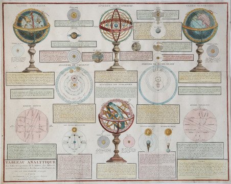

Tableau Analytique des différentes positions de la Sphère, des différens systèmes, des révolutions.
Tableau Analytique des différentes positions de la Sphère, des différens systèmes, des révolutions. | Gravures | DELAMARCHE Charles François
Mode de Paiement
- PayPal
- Carte bancaire
- Virement bancaire
- Pubblica amministrazione
- Carta del Docente
Détails
- Année
- 1809
- Lieu d'édition
- Parigi
- Format
- 640 X 510
- Graveurs
- DELAMARCHE Charles François
- Thème
- Carte Celesti
Description
Grande e fastosa stampa antica di astronomia, summa delle conoscenze del primissimo ottocento. Risaltano negli angoli superiori le rappresentazioni del globo celeste e del globo terrestre, mentre più al centro appaiono le sfere armillari con la teoria cosmologica di Copernico ed in basso quella di Tolomeo. Lo stesso sistema di Copernico assieme all'ipotesi di Ticho Brahe, che alla fine del Cinquecento conobbe una certa fortuna, sono delineati in piano in posizione centrale. Nel basso si illustrano i concetti di sfera dritta e sfera parallela assieme alle fasi della Luna e alla posizione reciproca di Terra, Sole e Luna nelle eclissi di Luna e di Sole. Ogni angolo libero viene riempito con le magnificamente fantasiose raffigurazioni dei pianeti tra i quali appare anche Herschel, primo nome che fu dato ad Urano in onore del suo scopritore, Pallade, Cerere, Giunone e Vesta, questi ultimi individuati ai primissimi del XIX secolo, quindi classificati tutti tra i pianeti e non ancora tra gli asteroidi. Ogni rappresentazione è accompagnata da un testo di descrizione con qualche notazione storica che affianca la parte più scientifica ed astronomica. Tavola tratta dal ' Recueil de cartes sur la géographie ancienne et moderne, à l'usage des élèves de l'Ecole Royale Militaire de Saint-Cyr, stampatp a Parigi e pubblicato in varie edizioni tra il 1806 e il 1825. Charles François Delamarche (1740 – 1817) è stato un geografo e cartografo francese. Fu uno dei più importanti geografi e cartografi francesi della seconda metà del Settecento. Successore di Nicolas Sanson (1600-1667), Robert de Vaugondy (1686-1766) e Rigobert Bonne (1727-1794), ne ristampò gli atlanti. Si dedicò all'insegnamento della geografia. Tra le sue opere, oltre alle carte e ai globi, va ricordato un trattato sull'uso della sfera, dei globi celesti e dei terrestri (Traité de la sphère et de l'usage des globes, 1790), in cui egli illustra, oltre al sistema tolemaico, anche quello copernicano, enumerando inoltre tutte le costellazioni antiche e moderne. Suo figlio Félix ne continuò l'opera. Charles François Delamarche acquisì la collezione di Didier Robert de Vaugondy nel 1778, dopo aver collaborato con lui nell'edizione di diversi atlanti. ' Acquaforte, impressa su carta vergata coeva, finemente colorata a mano, consuete pieghe di carta, in ottimo stato di conservazione. Bibliografia Moreland-Bannister “Antique Maps A Collector’s Guide” Oxford 1989 pag.136 e 139. Large and sumptuous antique print of astronomy, the summa of the knowledge of the very early nineteenth century. Stand out in the upper corners of the representations of the celestial globe and the terrestrial globe, while more to the center appear the armillary spheres with the cosmological theory of Copernicus and below that of Ptolemy. The same system of Copernicus together with the hypothesis of Ticho Brahe, which at the end of the sixteenth century had a certain fortune, are outlined on the plate in a central position. At the bottom, the concepts of straight sphere and parallel sphere are illustrated together with the phases of the Moon and the reciprocal position of Earth, Sun and Moon in eclipses of the Moon and Sun. Every free corner is filled with the magnificently imaginative depictions of the planets among which also appears Herschel, the first name given to Uranus in honor of its discoverer, Pallas, Ceres, Juno and Vesta, the latter identified at the very beginning of the nineteenth century, then classified all among the planets and not yet among asteroids. Each representation is accompanied by a text description with some historical notation that supports the more scientific and astronomical part. Plate taken from the ' Recueil de cartes sur la géographie ancienne et moderne, à l'usage des élèves de l'Ecole Royale Militaire de Saint-Cyr, printed in Paris and published in several editions between 1806 and 1825. Charles-François Delamarche (August 1740 – 31 October 1817) was a French geographer and mapmaker. One of the most important French geographers and mapmakers of the second half of the eighteenth century. Successor to Nicolas Sanson (1600 – 1667), Robert de Vaugondy (1686 – 1766), and Rigobert Bonne (1727 – 1794), whose atlases he reprinted. Also taught geography. In addition to maps and globes, his works include a treatise on the use of the sphere and celestial and terrestrial globes. In the treatise, he illustrates both the Ptolemaic and Copernican systems, as well as listing all the ancient and modern constellations. His son Félix Delamarche continued his work. Charles François Delamarche acquired Didier Robert de Vaugondy's collection in 1778, after having collaborated with him in the edition of atlases. Etching, printed on contemporary laid paper, showing the usual folds, a fine later hand coloring, in excellent condition. Bibliografia Moreland-Bannister “Antique Maps A Collector’s Guide” Oxford 1989 pag.136 e 139. Cfr.
