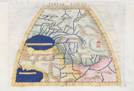
Tabula Asiae VII
Tabula Asiae VII | Gravures | RUSCELLI Girolamo

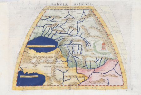
Tabula Asiae VII
Tabula Asiae VII | Gravures | RUSCELLI Girolamo
Mode de Paiement
- PayPal
- Carte bancaire
- Virement bancaire
- Pubblica amministrazione
- Carta del Docente
Détails
- Année
- 1561
- Lieu d'édition
- Venezia
- Format
- 260 X 190
- Graveurs
- RUSCELLI Girolamo
Description
La mappa di Ruscelli copre parti della Russia e dell'Asia, compresi i territori tra il Mar Caspio e il Golfo Persico. Questa mappa rappresenta un vasto tratto di questa parte dell'Asia, dall'Iran e dal Pakistan, attraverso il Turkmenistan e il Tagikistan fino al Kazakistan e oltre. La mappa nomina molti degli antichi regni di questa vasta regione, come gli Sciti, i Battriani e altri popoli antichi. La regione era attraversata da molte rotte commerciali che comprendevano l'antica e famosa Via della Seta, parte della quale è stata utilizzata almeno dal II secolo a.C. Ruscelli ha posizionato la famosa "Torre di pietra" sul Percorso all'estremo est della mappa, in un'area boscosa vicino alle montagne. La Torre era un importante punto di sosta per i viaggiatori, dove potevano riposarsi, imbarcare rifornimenti e decidere come proseguire il viaggio. Si pensa che la posizione precisa sia ai piedi del Pamir, confermando piuttosto la raffigurazione di Ruscelli. L'angolo sud-est della mappa comprende parte dell'India e la sorgente del fiume Gange. Viene anche delineato il sistema del fiume Indo. Carta tratta dalla ' Geographia di Claudio Tolomeo, a cura di Girolamo Ruscelli, pubblicata in Venezia in più edizioni tra il 1561 ed il 1598. La carta è basata sulla “Geografia” di Giacomo Gastaldi (1548), che probabilmente disegnò personalmente anche queste mappe, che vennero incise dai fratelli Livio e Giulio Sanuto. La peculiarità di queste mappe è che sono incise due per lastra e successivamente tagliate; questo il motivo per cui il segno del rame appare solo in tre lati della mappa. Il testo del Ruscelli e le sue carte sono considerate come il miglior atlante moderno fino alla prima versione del ' Theatrum ' ' Orbis Terrarum ' di Abraham Ortelius (1570). Solo la loro larga diffusione ne impedisce una valutazione sostenuta nel mercato antiquario. L'opera infatti ebbe una prima stesura nel 1561, stampata da Vincenzo Valgrisi che ne curò anche la ristampa del 1562. Tre sono le edizioni firmate da Giordano Ziletti (due nel 1564 e una del 1574), mentre nel 1597 viene edita dai fratelli Calignani. Tutte queste edizioni contengono 64 tavole. Nel 1598 e 1599 vengono alla luce le due edizioni curate da Giuseppe Rosaccio e stampate dagli Eredi di Melchior Sessa. Queste ultime due edizioni comprendono 69 tavole; sono infatti aggiunte la carta del planisfero e dei continenti di Rosaccio. Acquaforte e bulino, finemente colorata a mano, in ottimo stato di conservazione. Ruscelli’s map covers parts of Russia and Asia including the territories between the Caspian Sea and the Persian Gulf. This map spans a vast stretch of this portion of Asia, from Iran and Pakistan, up through Turkmenistan and Tajikistan to Kazakhstan and beyond. The map names many of the ancient kingdoms of this vast region, such as the Scythians, Bactrians, and other ancient peoples. The region was crisscrossed by many trade routes which comprised the ancient and famed Silk Route, parts of which have been in use since at least the 2nd ' century BCE. ' Ruscelli positioned the famed ‘Stone Tower’ on the Route to the far east of the map, in a forested area close to mountains. The Tower was an important stopping point for travelers, where they could rest, take on supplies, and reach a decision as to how to continue their journey. The precise location is thought to be in the foothills of the Pamirs, rather confirming Ruscelli’s depiction of it. Many extensive mountain ranges are shown and complex major river systems are depicted. The southeast corner of the map includes part of India and the source of the Ganges River. The Indus River system is also delineated. ' Italian text on the verso describes the region and the peoples inhabiting it. Map taken from ' Geographia di Claudio Tolomeo ' edited by Girolamo Ruscelli, published in Venice in several editions between 1561 and 1598. The maps is based on the ' Geografia ' by Giacomo Gastaldi (1548), who probably also personally drew these maps, which were engraved by the brothers Livio and Giulio Sanuto. The peculiarity of these maps is that they are engraved two for plate and subsequently cut; this is why the copper sign only appears on three sides of the map. Ruscelli's text and his maps are considered to be the best modern atlas up to the first version of Abraham Ortelius' ' Theatrum Orbis Terrarum ' (1570). Only their widespread diffusion prevents a sustained evaluation in the antiquarian market. In fact, the work had a first edition in 1561, printed by Vincenzo Valgrisi who also edited the 1562 reprint. There are three editions signed by Giordano Ziletti (two in 1564 and one in 1574), while in 1597 it was published by the Calignani brothers. All these editions contain 64 plates. In 1598 and 1599 the two editions edited by Giuseppe Rosaccio and printed by the heirs of Melchior Sessa came to light. These last two editions include 69 plates; in fact, Rosaccio's map of the planisphere and continents has been added. Etching and engraving with fine later hand colour, in good condition. Cfr.
