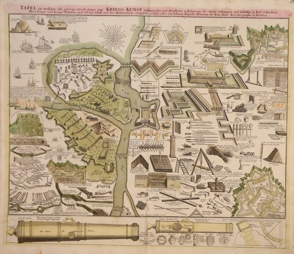
Tafel…zur Kriegs-Kunst Vestungs-bau und Artillerie, zu Belagerung der Statte Vestungen…
Tafel…zur Kriegs-Kunst Vestungs-bau und Artillerie, zu Belagerung der Statte Vestungen… | Gravures | HOMANN Johann Baptist

Tafel…zur Kriegs-Kunst Vestungs-bau und Artillerie, zu Belagerung der Statte Vestungen…
Tafel…zur Kriegs-Kunst Vestungs-bau und Artillerie, zu Belagerung der Statte Vestungen… | Gravures | HOMANN Johann Baptist
Mode de Paiement
- PayPal
- Carte bancaire
- Virement bancaire
- Pubblica amministrazione
- Carta del Docente
Détails
- Année
- 1716
- Lieu d'édition
- Norimberga
- Format
- 595 X 500
- Graveurs
- HOMANN Johann Baptist
- Thème
- Militaria
Description
Interessante tavola storico-militare che mostra l'arte della guerra attraverso la rappresentazione di utensili da campo, bombe e armi di artiglieria, quali cannoni e mortai, nonché il corretto posizionamento delle batterie, delle fortificazioni, e alcuni modelli di navi utilizzate per le battaglie. Nella parte inferiore della tavola, la descrizione dei vari componenti di due grandi cannoni di bronzo. La carta fu realizzata da Homann per il suo Grosser Atlas. Johann Baptist Homann è stato un geografo e cartografo tedesco; nel 1702 fondò la sua casa editrice. Homann acquisì fama come uno dei principali cartografi tedeschi, e nel 1715 fu nominato geografo imperiale dall'imperatore Carlo VI. Nello stesso anno fu anche nominato membro dell'Accademia Prussiana delle Scienze a Berlino. Nel 1716 Homann pubblicò il suo capolavoro Grosser Atlas ueber die ganze Welt. Numerose mappe furono redatte in collaborazione con l'incisore Christoph Weigel. Homann morì a Norimberga nel 1724. Gli successe suo figlio Johann Christoph (1703-1730). L'azienda continuò dopo la sua morte come azienda degli eredi Homann, gestita da Johann Michael Franz e Johann Georg Ebersberger. Dopo successivi cambiamenti nella gestione, l'azienda si sciolse nel 1852. ' Incisione in rame, colorata a mano, in buone condizioni. This great military-themed engraving is filled with images explaining the art and weaponry of war. On display are weaponry including various sizes and types of cannons and mortars. It shows the correct positioning of batteries, plus shells, bombs, and other artillery pieces. Sea battles, the structure of fortified batteries or forts, and much more are illustrated. At bottom are two large bronze cannons with their various elements. ' The map was made by Homann for his Grosser Atlas. Johann Baptist Homann was a German geographer and cartographer; in 1702 he founded his own publishing house. Homann acquired renown as a leading German cartographer, and in 1715 was appointed Imperial Geographer by Emperor Charles VI. In the same year he was also named a member of the Prussian Academy of Sciences in Berlin. In 1716 Homann published his masterpiece Grosser Atlas ueber die ganze Welt; numerous maps were drawn up in cooperation with the engraver Christoph Weigel the Elder. Homann died in Nuremberg in 1724 and was succeeded by his son Johann Christoph (1703-1730). The company carried on upon his death as Homann heirs company, managed by Johann Michael Franz and Johann Georg Ebersberger. After subsequent changes in management the company folded in 1852. ' Etching with fine original colour, good condition. Cfr.
