Terra Sancta
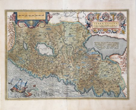
Terra Sancta
Mode de Paiement
- PayPal
- Carte bancaire
- Virement bancaire
- Pubblica amministrazione
- Carta del Docente
Détails
- Année
- 1595
- Lieu d'édition
- Anversa
- Format
- 505 X 370
- Graveurs
- ORTELIUS Abraham
Description
Titolo nel cartiglio in alto a sinistra: TERRA SANCTA, | "A Petro Laicstain perlustrata, et ab eius ore | et schedis à Christiano Schrot in tabulam redacta". In mezzo al centro, nel Mar Morto, si legge: MARE MORTVVM, "olim Salinarum | vallis, predicatæ foecundidatis, et amoenitatis : quam Iordanis | mediam irrigabat. adeò vt ob felicitatem paradiso Dei | conferebatur. Post autem Sodoma euersa, et vicina | opida, mutata est in illam sterilitatem, qua hodie | adhuc conspicitur. Diuinæ ultionis admiranda | vestigia". Bella mappa della Terra Santa basata sul lavoro di Petrus Laicksteen, un astronomo olandese di cui non conosciamo le date di nascita e morte, che raccolse materiale topografico sulla Palestina durante il suo soggiorno lì nel 1556. Questo fu utilizzato da Christian Sgrothen (ca. 1520- 1608) che pubblicò una mappa di nove fogli della Palestina, stampata nel 1570 presso Hieronymous Cock (Karrow 70/10, p. 484, Meurer p. 180, 239). Esemplare del secondo stato, che compare nell'edizione successiva al 1595 del Theatrum Orbis Terrarum. Dalla rara edizione italiana del Theatrum Orbis Terrarum stampata ad Anversa da Jean Baptiste Vrients nel 1608 e poi nel 1612. Il Theatrum Orbis Terrarum ' è considerato il primo vero “atlante” moderno. L’opera fu pubblicata in 7 lingue e 36 edizioni, per il quale – nel 1570 - Ortelius ottenne il ' privilegio, ovvero una sorta di diritto d'autore che impediva ad altri cartografi di pubblicare i propri lavori. Il ' Theatrum ' rappresentava il lavoro più avanzato del lavoro della descrizione cartografica. L’Ortelius vi raccolse il sapere geografico e cartografico del suo tempo, proponendo in 147 spettacolari tavole incise l’immagine più fedele del mondo allora conosciuto e, in alcune straordinarie “carte storiche”, regioni e itinerari tratti dalla letteratura, dalla mitologia, dalla tradizione. Ortelius fu anche il primo a citare le fonti, menzionando i nomi dei cartografi nel “catalogus auctorum”. Dal 1598 al 1612 le edizioni postume del ' Theatrum ' furono realizzate dal suo collaboratore Johannes Baptiste Vrients. Acquaforte, finemente colorata in epoca, restauri lungo la piega centrale e al testo al verso, per il resto in buono stato di conservazione. Bibliografia Van den Broecke, Ort 173 II; Koeman/Meurer: 106, Karrow: 1/153, vdKrogtAN: 8150:31C. Title: TERRA SANCTA, | "A Petro Laicstain perlustrata, et ab eius ore | et schedis à Christiano Schrot in tabulam redacta". Middle right: MARE MORTVVM, "olim Salinarum | vallis, predicatæ foecundidatis, et amoenitatis : quam Iordanis | mediam irrigabat. adeò vt ob felicitatem paradiso Dei | conferebatur. Post autem Sodoma euersa, et vicina | opida, mutata est in illam sterilitatem, qua hodie | adhuc conspicitur. Diuinæ ultionis admiranda | vestigia". Fine map of Holy Land based on the work of Petrus Laicksteen, a Dutch astronomer whose dates of birth and death we do not know, collected topographic material on Palestine during his stay there in 1556. This was used by Christian Sgrothen (abt. 1520-1608) who published a nine-sheet map of Palestine in 1570 at Hieronymous Cock (Karrow 70/10, p. 484, Meurer p. 180, 239). Example of the second state of the plate, published in the Theatrum Orbis Terrarum ' printed after 1595. From the rare Italian edition of ' Theatrum Orbis Terrarum ' printed in Antwerp by Jean Baptiste Vrients in 1608 and then in 1612. The ' Theatrum Orbis Terrarum is considered the first true modern "Atlas". The work was published in 7 languages and 36 editions, for which - in 1570 - Ortelius obtained the privilege, a kind of copyright that prevented other cartographers from publishing his works. The ' Theatrum ' represented the most advanced work of cartographic description. Ortelius collected in it the geographical and cartographic knowledge of his time, proposing in 147 spectacular engraved plates the most faithful image of the world then known and, in some extraordinary "historical maps", regions and routes taken from literature, mythology, tradition. Ortelius was also the first to cite sources, mentioning the names of cartographers in the "catalogus auctorum". From 1598 to 1612 the posthumous editions of the ' Theatrum ' were made by his collaborator Johannes Baptiste Vrients. Etching, finely colored at the time, restorations along the central fold and on the text on the reverse, otherwise in good condition. Bibliografia Van den Broecke, Ort 173 II; Koeman/Meurer: 106, Karrow: 1/153, vdKrogtAN: 8150:31C. Cfr.