The English pilot. Part III: Describing the Sea-coasts, Capes, Head-lands, Bays, Roads, Harbours, Rivers and Ports, together
The English pilot. Part III: Describing the Sea-coasts, Capes, Head-lands, Bays, Roads, Harbours, Rivers and Ports, together
Mode de Paiement
- PayPal
- Carte bancaire
- Virement bancaire
- Pubblica amministrazione
- Carta del Docente
Détails
- Année
- 1781
- Lieu d'édition
- Londra
- Format
- 0 X 0
- Graveurs
- MOUNT & PAGE
- Thème
- Libri Antichi
- Description
- S. Bifolco, "Mare Nostrum, Cartografia nautica a stampa del Mar Mediterraneo" (2020), pp. 218-219, tav. 100.
Description
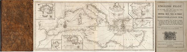
The English pilot. Part III: Describing the Sea-coasts, Capes, Head-lands, Bays, Roads, Harbours, Rivers and Ports; together with the Soundings, Sands, Rocks and Dangers in the whole Mediterranean Sea, likewise the Courses and Distances from one Place to another. The Setting of the Tides and Currents. The Ebbing and Flowing of the Sea. The Bearing, Distance and Prospect of the Land, and how thwy shew themselves at Sea. Carefully corrected, with new Additions of several Ports, Harbours, Bays, and Prospects of Land, never before made Public, London, Printed for J. Mount, and T. Page on Tower-Hill MDCCLXXXI (1781).Volume in-folio (480x310 mm), legatura coeva in pelle, 86+38 pp., 17 carte geografiche incise a doppioa pagina, una più volte ripiegata raffigurante l'intero Mediterraneo pubblicata per la prima volta da Charles Price nel 1730.Il The English Pilot fu un importante atlante nautico britannico, pubblicato dal 1671 al 1803.Ideato da John Seller, venne proseguito dltri editori tra cui Charles Price, John Thornton e la ditta Mount & Page.La parte III copre tutto il Mar Mediterraneo, in 14 sezioni, con frontespizio, testo descrittivo e un set di diciassette mappe. Le carte dell'Englis Pilot erano intese come carte per la navigazione, quindi ci fu uno sforzo per renderle accurate. L'opera include la grande carta nautica del Mar Mediterraneo, arricchita da cartigli contenenti piani nautici di Civitavecchia, Livorno, Nettuno e delle baie di Tunisi e Alessandretta. La carta è firmata da William Mount e Thomas II Page, rispettivamente figlio di Richard e Thomas I. Un esemplare della tavola, con la data 1730 è conservato in una raccolta di carte - senza titolo e data - di Charles Price nella collezione della British Library (Maps C.8.b.16, cfr. Shirley p. 1270, M.PRI-1a, 19). Charles Price finì in prigione (1731) per non aver onorato i propri debiti economici; probabile quindi che la lastra passò nelle mani della tipografia Mount & Page. La troviamo inclusa nel volume III del The English Pilot, curata dagli editori John Mount e Thomas II Page tra il 1730 ed il 1771 (cfr. Shirley, p. 1260, M.M&P-8°, 6). La data “1730” viene abrasa nelle tirature successive dell’opera. Il terzo volume dell’English Pilot, è noto in 19 diverse edizioni, a partire dal 1703 e fino al 1803. Basato sulle carte del Mediterraneo stampate da John Seller nel 1677, viene in seguito aggiornato da nuove e migliori carte.Bibliografia: cfr. National Maritime Museum, Catalogue of the Library - Vol. Three, Atlas & Cartography, Londra, 1971, pp. 460-462; R. Shirley, Maps in the Atlases of the British Library, Londra, 2004, pp. 1257, M.M&P-7c, (1, 2); p. 1260, M.M&P-8a (6); pp. 1263-1264, M.M&P-13b (11); p. 1270, M.PRI-1a (19); cfr. The Compleat Plattmaker: essays on Chart, Map and Globe Making in England in the Seventeenth and Eighteenth Centuries, Berkeley, 1978. The English pilot. Part III: Describing the Sea-coasts, Capes, Head-lands, Bays, Roads, Harbours, Rivers and Ports; together with the Soundings, Sands, Rocks and Dangers in the whole Mediterranean Sea, likewise the Courses and Distances from one Place to another. The Setting of the Tides and Currents. The Ebbing and Flowing of the Sea. The Bearing, Distance and Prospect of the Land, and how thwy shew themselves at Sea. Carefully corrected, with new Additions of several Ports, Harbours, Bays, and Prospects of Land, never before made Public, London, Printed for J. Mount, and T. Page on Tower-Hill MDCCLXXXI (1781).Folio (480 x 310 mm), J. Mount, T. Page, 1781, Contemporary calf, woodcut Royal arms on title, 17 engraved maps, woodcut coastal profiles and illustrations in the text.The English Pilot was an important British sea-atlas published from 1671 to 1803. Initially published by John Seller, publication of the atlas changed hands periodically, with other publishers including Charles Price, John Thornton, and the Mount & Page firm. Part III covers the whole Mediterranean Sea, in 14 sections, with title page, descriptive text, and set of seventeen maps. Features a large folding map titled "A Correct Chart of the Mediterranean Sea from the Coast of Portugal to the Levant." and 16 other maps which are double-page folio sheets covering parts of the Mediterranean and are all embellished with compass roses, rhumb lines and costal profiles.The charts from the English Pilot were intended as working charts so there was an effort to make them accurate, although predictably, many seamen complained that the charts were consistently out of date and that changes were slow to appear, a charge levelled at virtually every British, French and American Chart maker, including the respective governments of these nations. Ironically, it was in no small part due to the proprietary nature of the information included in the maps and sailing directions that there was a tendency for commercial pilots to pass the information from mariner to chart-maker more slowly than might otherwise have been the case, although the chart makers on the Thames and otherwise were undoubtedly reluctant to immediately make each and every necessary correction, for fear of undermining the economic viability of their businesses.Bibliografia: cfr. National Maritime Museum, Catalogue of the Library - Vol. Three, Atlas & Cartography, Londra, 1971, pp. 460-462; R. Shirley, Maps in the Atlases of the British Library, Londra, 2004, pp. 1257, M.M&P-7c, (1, 2); p. 1260, M.M&P-8a (6); pp. 1263-1264, M.M&P-13b (11); p. 1270, M.PRI-1a (19); cfr. The Compleat Plattmaker: essays on Chart, Map and Globe Making in England in the Seventeenth and Eighteenth Centuries, Berkeley, 1978. Cfr. S. Bifolco, "Mare Nostrum, Cartografia nautica a stampa del Mar Mediterraneo" (2020), pp. 218-219, tav. 100.