Urbis Romae Veteris ac Modernae accurata delineatio…
Urbis Romae Veteris ac Modernae accurata delineatio… | Gravures | HOMANN Johann Baptist
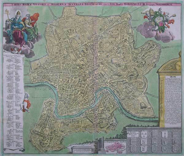

Urbis Romae Veteris ac Modernae accurata delineatio…
Urbis Romae Veteris ac Modernae accurata delineatio… | Gravures | HOMANN Johann Baptist
Mode de Paiement
- PayPal
- Carte bancaire
- Virement bancaire
- Pubblica amministrazione
- Carta del Docente
Détails
- Année
- 1716
- Lieu d'édition
- Norimberga
- Format
- 580 X 490
- Graveurs
- HOMANN Johann Baptist
- Thème
- Piante e Panorami di Roma
- Description
- Huelsen (1915): n. 124a; Scaccia Scarafoni (1939): n. 210; C. Marigliani, "Le Piante di Roma delle collezioni private", tav. 133.
Description
Pianta a proiezione mista, orientata con il nord a sinistra, ripresa dalla pianta di Giovan Battista Falda. "E' una copia della pianta di Johannes De Ram senza alcun aggiornamento. In alto a destra lo stemma di Clemente XI (1700-1721). Sebbene stampata intorno al 1720 raffigura la città alla fine del Seicento, come avviene per un cospicuo nucleo di piante derivate dal Falda ed edite nel Nord Europa in questo periodo, nelle quali tutti i cambiamneti si concentrano nei nuovi apparati decorativi e non nel contenuto della pianta stessa" (cfr. Marigliani p. 229, n. 133). La carta fu realizzata da Homann per il suo Grosser Atlas. Johann Baptist Homann è stato un geografo e cartografo tedesco; nel 1702 fondò la sua casa editrice. Homann acquisì fama come uno dei principali cartografi tedeschi, e nel 1715 fu nominato geografo imperiale dall'imperatore Carlo VI. Nello stesso anno fu anche nominato membro dell'Accademia Prussiana delle Scienze a Berlino. Nel 1716 Homann pubblicò il suo capolavoro Grosser Atlas ueber die ganze Welt. Numerose mappe furono redatte in collaborazione con l'incisore Christoph Weigel. Homann morì a Norimberga nel 1724. Gli successe suo figlio Johann Christoph (1703-1730). L'azienda continuò dopo la sua morte come azienda degli eredi Homann, gestita da Johann Michael Franz e Johann Georg Ebersberger. Dopo successivi cambiamenti nella gestione, l'azienda si sciolse nel 1852. ' Acquaforte, bella coloritura coeva editoriale, in buono stato di conservazione. Mixed projection map, oriented with north on the left, based on the map of Giovan Battista Falda. It is a close copy of the map of Johannes De Ram without any update. In the upper right corner is the coat of arms of Clemente XI (1700-1721). Although printed around 1720 it depicts the city at the end of the seventeenth century, as is the case for a large group of maps derived from Falda and published in Northern Europe in this period, in which all the changes are concentrated in the new decorative apparatus and not in the content of the map itself (see Marigliani p. 229, n. 133). The map was made by Homann for his Grosser Atlas. Johann Baptist Homann was a German geographer and cartographer; in 1702 he founded his own publishing house. Homann acquired renown as a leading German cartographer, and in 1715 was appointed Imperial Geographer by Emperor Charles VI. In the same year he was also named a member of the Prussian Academy of Sciences in Berlin. In 1716 Homann published his masterpiece Grosser Atlas ueber die ganze Welt; numerous maps were drawn up in cooperation with the engraver Christoph Weigel the Elder. Homann died in Nuremberg in 1724 and was succeeded by his son Johann Christoph (1703-1730). The company carried on upon his death as Homann heirs company, managed by Johann Michael Franz and Johann Georg Ebersberger. After subsequent changes in management the company folded in 1852. Etching with fine original colour, good condition. Cfr. Huelsen (1915): n. 124a; Scaccia Scarafoni (1939): n. 210; C. Marigliani, "Le Piante di Roma delle collezioni private", tav. 133.
