Valetta Civitas Nova Maltae
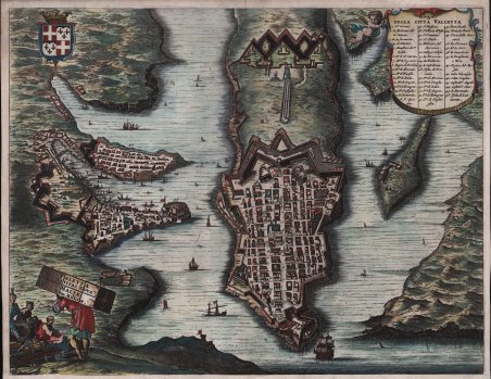
Valetta Civitas Nova Maltae
Mode de Paiement
- PayPal
- Carte bancaire
- Virement bancaire
- Pubblica amministrazione
- Carta del Docente
Détails
- Année
- 1676
- Lieu d'édition
- Amsterdam
- Format
- 365 X 565
- Graveurs
- DAPPER Olfert
Description
Magnifica pianta a volo d'uccello del porto e della città di La Valletta. Vista da nord-ovest, la città è ricca di dettagli, anche se probabilmente disposta in modo più geometrico rispetto alla realtà. A sinistra della capitale sono raffigurate anche le città circostanti di Senglea e Vittoriosa e il Forte Ricasoli. Un cartiglio figurato in basso a sinistra mostra un gruppo di uomini, uno dei quali porta sulle spalle un baule con il titolo. Le acque circostanti sono piene di navi decorative e nell'angolo in alto a sinistra è disegnato uno stemma francese che indica il controllo coloniale della Francia sulla regione. La mappa è tratta dal Naukeurige beschrijvinge der Afrikaensche gewesten van Egypten, Barbaryen, Lybien, Biledulgerid, Negroslant, Guinea, Ethiopiën, Abyssinie: vertoont in de benamingen, grenspalen, revieren, steden, gewassen, dieren, zeeden, drachten, talen, rijkdommen, godsdiensten en heerschappyen pubblicato ad Amsterdam, da Jacob van Meurs, 1676. Lo scrittore di Amsterdam Olfert Dapper (1636-1689) fu celebrato dai suoi contemporanei per le sue descrizioni di terre lontane. Iniziò la sua carriera di scrittore con una descrizione di Amsterdam, la città in cui visse per tutta la vita. La sua descrizione dell'intero continente africano e delle sue isole fu pubblicata per la prima volta nel 1668, all'inizio della sua carriera. Oggi è considerata la sua opera migliore e fu tradotta in tedesco e inglese nel 1670 e in francese nel 1686. La seconda edizione, apparsa nel 1676, fu molto ampliata e contiene numerose aggiunte, tra le quali la carta di Malta e la pianta di Valletta. L'attenzione di Dapper era rivolta soprattutto al Nord dell'Africa islamica, con descrizioni estese e approfondite dell'area tra il Marocco e l'Egitto e dell'Impero etiope (Abissinia). Le sue mappe dell'intera Africa, dell'Egitto e dell'Etiopia includono la penisola arabica fino al Golfo Persico e forniscono una visualizzazione dettagliata del Mar Rosso. L'approccio interdisciplinare di Dapper era innovativo; egli compilò la sua descrizione dell'Africa attingendo a varie fonti, tra cui relazioni olandesi inedite e testimonianze oculari, la maggior parte delle quali oggi perdute o scarse, il che rende questa prima opera sull'Africa di valore duraturo per la storia del continente. Acquaforte, rifilata al margine o con margini sottili (come pubblicata), finemente colorata a mano, ottimo stato di conservazione. Magnificent bird's-eye plan of the harbor and city of Valletta seen from the northwest. Beautifully engraved with a unique pictorial title cartouche, ships, a coat of arms and a decorative key locating 46 sites within the city. Seen from the northwest, the city is richly detailed, although likely arranged more geometrically than in reality. Surrounding cities of Senglea and Vittoriosa, as well as Fort Ricasoli, are also shown to the left of the capital. A figured title cartouche in the lower left shows a group of men, one carrying a trunk on his back bearing the title. The surrounding waters are filled with decorative ships, and a French coat of arms is drawn in the upper left corner to indicate France's colonial control of the region. The map is taken from the Naukeurige beschrijvinge der Afrikaensche gewesten van Egypten, Barbaryen, Lybien, Biledulgerid, Negroslant, Guinea, Ethiopiën, Abyssinie: vertoont in de benamingen, grenspalen, revieren, steden, gewassen, dieren, zeeden, drachten, talen, rijkdommen, godsdiensten en heerschappyen. . published in Amsterdam, by Jacob van Meurs, 1676. The Amsterdam author Olfert Dapper (1636-1689) was celebrated by his contemporaries for his descriptions of far away lands. He started his writing career with a description of Amsterdam, the city where he lived all his life. His description of the entire continent of Africa and its islands was first published in 1668, which was still early in his career. It is now accepted as his best work and was translated into German and English in 1670, and into French in 1686. The second edition, appeared in 1676 and was much enlarged. Dapper's attention was mainly drawn to the Islamic North of Africa, with extensive and thorough descriptions of the area between Morocco and Egypt (with a magnificent illustration of pyramids) and the Ethiopian Empire (Abyssinia). Its maps of the whole of Africa, Egypt and Ethiopia include the Arabian Peninsula as far as the Persian Gulf and provide a detailed display of the Red Sea. Dapper's interdisciplinary approach was innovative. He compiled his description of Africa from various sources, including unpublished Dutch reports and eye-witness accounts, most of them now lost or scarce, which makes this early work on Africa of enduring value for the history of the continent. Copperplate, trimmed at the borderline or with thin margins (as issued), fine later hand colour, very good condition. Cfr.