Vera Pianta di Candia Assediata da Turchi
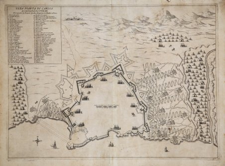
Vera Pianta di Candia Assediata da Turchi
Mode de Paiement
- PayPal
- Carte bancaire
- Virement bancaire
- Pubblica amministrazione
- Carta del Docente
Détails
- Année
- 1669
- Lieu d'édition
- Roma
- Format
- 535 X 390
- Graveurs
- Lhuilier Joannes
Description
Rarissima pianta dell’assedio di Candia incisa – e probabilmente pubblicata - da Johannes Lhuilier. L’opera non è presente nelle principali collezioni di grafica, e non abbiamo avuto riscontro di altri esemplari. In alto a destra, entro riquadro, il titolo VERA PIANTA DI CANDIA ASSEDIATA DAI TURCHI. Dissegnata da Dioniso Spada, e Intagliata da Lhuilier in Roma. Segue una legenda numerica di 66 rimandi. In basso l’orientazione con una rosa dei venti, con il Nord in basso. Veduta obliqua dall'alto e mappa della città di Candia, assediata dai Turchi dal 1° maggio 1648 al 27 settembre 1669 e difesa dalle forze veneziane del capitano generale Francesco Morosini (26 febbraio 1619-16 gennaio 1694), che alla fine rinunciarono alla città e cedettero Creta agli Ottomani nel 1669. Questa stampa è molto vicina, per stile e contenuto, a un'altra combinazione di veduta-mappa intitolata CITTA DI CANDIA ASSEDIATA, pubblicata nel 1651 come lastra 25 de Il regno tutto di Candia di Marco Boschini. La mappa dell'assedio di Boschini del 1651 presenta ulteriori dettagli che suggeriscono che essa mostra una fase leggermente successiva dell'assedio. Il prototipo per entrambe è, però, un’anonima mappa datata 1648, probabilmente di scuola italiana (cfr. McDonald n. 3023, che descrive l’esemplare RCIN 723080 del Royal Collection Trust). L’evento fu talmente importante che le tipografie dell’epoca, soprattutto quelle romane, stamparono una ricca serie di documenti dell’assedio. In particolare, fu molto attivo a riguardo l’incisore ed editore di origini francesi Francois Collignon (1610 ca. – 1687), autore di almeno 10 tavole sull’assedio di Candia. Questa tavola di Johannes Lhuilier è priva di data. Lhuilier, altro incisore di origini francesi attivo a Roma, lavorava presso la tipografia di Giovanni Giacomo de Rossi tra il 1660 e il 1670. Per l’editore aveva intagliato diverse mappe per il Mercurio Geografico. Tuttavia, la mancanza di un imprint editoriale lascia supporre che in questo caso Lhuilier sia anche lo stampatore. Del resto, la tavola non è menzionata nell’Indice De Rossi, il catalogo della tipografia romana. Questo potrebbe spiegare la sua grandissima rarità. Acquaforte, impressa su carta vergata coeva, con margini, in ottimo stato di conservazione. Rarissima. Bibliografia cfr. Mark McDonald, ' The Print Collection of Cassiano dal Pozzo. ' Part II, ' Architecture, Topography and Military Maps, 3 vols, London 2019, cat. no. 3203; cfr. J. Ostwald, ' Vauban under siege: engineering efficiency and martial vigour in the War of the Spanish Succession, Leiden 2007. Very rare map of the siege of Candia engraved-and probably published-by Johannes Lhuilier. The work is not found in major graphic collections, and we have had no records of other examples. In the upper right, within inset, the title VERA PIANTA DI CANDIA ASSEDIATA DAI TURCHI. Dissegnata da Dioniso Spada, e Intagliata da Lhuilier in Roma. A numerical legend of 66 cross-references follows. Below is the orientation with a wind rose, with North at the bottom. Oblique view from above and map of the city of Candia, besieged by the Turks from May 1, 1648, to September 27, 1669, and defended by the Venetian forces of Captain General Francesco Morosini (Feb. 26, 1619-Jan. 1694), who eventually surrendered the city and ceded Crete to the Ottomans in 1669. This print is very close in style and content to another view-map combination entitled CITTA DI CANDIA ASSEDIATA, published in 1651 as plate 25 of Marco Boschini's Il regno tutto di Candia. Boschini's 1651 siege map has additional details suggesting that it shows a slightly later phase of the siege. The prototype for both, however, is an anonymous map dated 1648, probably of the Italian school (see McDonald No. 3023, describing the Royal Collection Trust example RCIN 723080). The event was so important that the printers of the time, especially those in Rome, printed a rich series of documents of the siege. In particular, the French-born engraver and publisher Francois Collignon (c. 1610 - 1687), author of at least 10 plates on the siege of Candia, was very active in this regard. This plate by Johannes Lhuilier is undated. Lhuilier, another French-born engraver active in Rome, worked at the printing house of Giovanni Giacomo de Rossi between 1660 and 1670. For the publisher he had carved several maps for the Mercurio Geografico. However, the lack of an editorial imprint suggests that in this case Lhuilier was also the printer. For that matter, the plate is not mentioned in the De Rossi Indice, the Roman printer's catalog. This may explain its very great rarity. Etching, printed on contemporary laidpaper, with margins, in very good condition. Very rare. Bibliografia cfr. Mark McDonald, ' The Print Collection of Cassiano dal Pozzo. ' Part II, ' Architecture, Topography and Military Maps, 3 vols, London 2019, cat. no. 3203; cfr. J. Ostwald, ' Vauban under siege: engineering efficiency and martial vigour in the War of the Spanish Succession, Leiden 2007. Cfr.