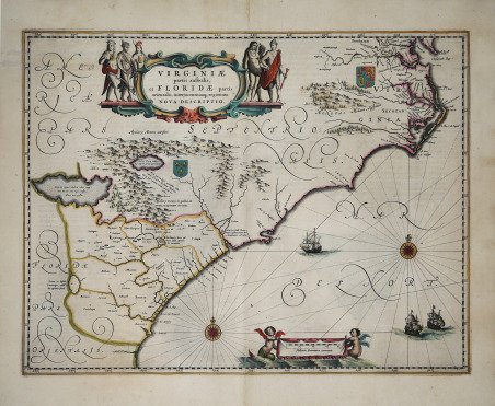
Virginiae partis australis, et Floridae partis orientalis, interjacentumque regionum Nova Descriptio
Virginiae partis australis, et Floridae partis orientalis, interjacentumque regionum Nova Descriptio
Mode de Paiement
- PayPal
- Carte bancaire
- Virement bancaire
- Pubblica amministrazione
- Carta del Docente
Détails
- Année
- 1639
- Lieu d'édition
- Amsterdam
- Format
- 510 X 390
- Graveurs
- JANSSONIUS Johannes
- Description
- Burden 254. Cumming 42.
Description
Bell'esemplare della carta di Jansson del sud-est del Nord America. La carta della Carolina di Jansson e quella di Blaeu sono praticamente indistinguibili dal punto di vista cartografico, anche se ci sono alcune piccole differenze negli abbellimenti. Entrambe le mappe si basano sulla carta della Carolina di Mercator-Hondius del 1606, ma con significativi miglioramenti. La mappa copre un'area che va dalla foce della Baia di Chesapeake alla Georgia e riflette gli interessi contrastanti di Francia e Inghilterra nel Nuovo Mondo, con gli stemmi di ciascun Paese che identificano il controllo regionale. Il miglioramento maggiore si verifica nella metà settentrionale della mappa a nord di Porto Royal. Mentre nella mappa di Hondius la linea di costa verso C. de. Ste. Romano (l'attuale Cape Fear) si dirigeva direttamente verso est, Blaeu la porta più correttamente a nord-est, posizionando il promontorio più vicino alla sua vera posizione di 34 gradi. Questo tratto di costa corrisponde all'incirca a quello dell'attuale Carolina del Sud. Include i meravigliosi laghi mitici dell'interno e altre congetture cartografiche dell'epoca. Grande cartiglio, 2 stemmi, 2 rose dei venti e diversi velieri. La carta di Blaeu è quasi identica a quella di Jansson. Il modo più semplice per distinguere le due carte è il numero longitudinale errato 200 nell'angolo inferiore destro della carta di Blaeu. Il numero corretto (300) appare sulla mappa di Jansson. Il cartiglio decorativo con il titolo circondato da figure di nativi americani, in alto, e l'elaborata calligrafia contribuiscono a renderla una delle mappe di maggior successo artistico dell'America del XVII secolo.Incisione in rame, finemente colorata a mano, in ottimo stato di conservazione. Nice example of Jansson's map of the Southeast. Jansson's map of the Carolinas and Blaeu's map of the Carolinas are virtually indistinguishable cartographically, although there are a number of minor differences in the embellishments. Both maps are on the larger 1606 Mercator-Hondius map of the Carolinas but with significant improvements. The map covers an area from the mouth of the Chesapeake Bay to Georgia and reflects the competing interests of France and England in the New World, with the coat of arms of each country identifying the regional control. As noted by Burden, the French claims are supported primarily by the French colonization efforts of the 1560s. As noted by Burden, The greatest improvement occurs in the northern half of the map north of Porto Royal. Whereas on the Hondius [map] the coastline towards C. de. Ste. Romano (present day Cape Fear) veered directly east, Blaeu more correctly takes it north-east, placing the cape closer to its true position of 34 degrees. This span of coastline is approximately that of present day South Carolina. This now presents to us a more accurately proportioned Outer Banks region, radically reduced in size but still slightly too far north. For these improvements, Blaeu drew upon the extremely rare DE EYLANDEN . . . by Hessel Gerritsz., c. 1631. The Outer Banks combine the placenames of Gerritsz and Hondius, often using two different ones for the same area . . . Chesapeake Bay was depicted just as a small bay on Hondius' map of 1606, as John Smith was yet to explore these waters. The Gerritsz terminated at this point, and only two placenames appeared. Blaeu draws largely on Smith's map for much of the nomenclature, but introduces some English [names] from an unknown source. The most important is Newport News. Newport News, founded in 1621 and apparently shown here for the first time on a printed map. Also new are Bermouth, Stortingen and Arglas . . . Includes the marvelous mythical lakes in the interior and other conjectural cartography of the time. Large cartouche, 2 coats of arms, 2 compass roses and several sailing ships. Blaeu's map is nearly identical to Jansson's map. The easiest way to distinguish the two maps is by the erroneous longitudinal number 200 in the lower right corner on Blaeu's map. The correct number (300) appears on Jansson's map. Copperplate with fine later hand colour, very good condition. Cfr. Burden 254. Cumming 42.