Virginiae partis australis et Floridae….
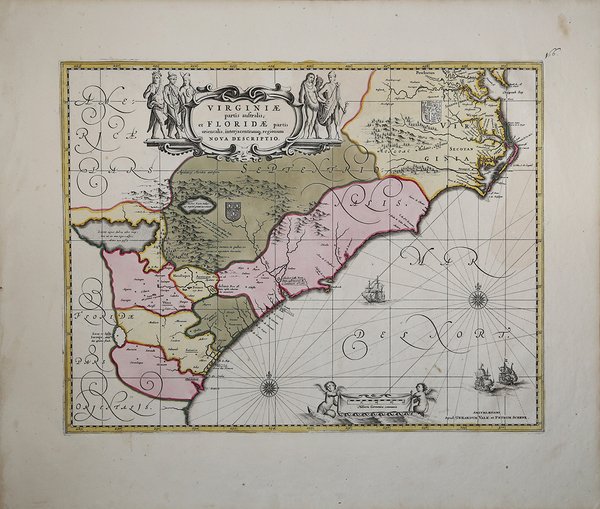
Virginiae partis australis et Floridae….
Mode de Paiement
- PayPal
- Carte bancaire
- Virement bancaire
- Pubblica amministrazione
- Carta del Docente
Détails
- Année
- 1639
- Lieu d'édition
- Amsterdam
- Format
- 500 X 380
- Graveurs
- JANSSONIUS Johannes
Description
Una bellissima mappa che è una delle mappe più interessanti del sud-est americano. La mappa si basa sulla carta di Hondius Jodocus con qualche aggiornamento. Ciò dimostra l'influenza della mappa Hondius, e il suo modo mappa portato ad una larga diffusione sia le informazioni corrette e gli errori. La mappa di Hondius era una combinazione di informazioni provenienti da due mappe cinquecentesche, una delle Carolina, e una della Florida / Georgia. Questi sono stati combinati, e nel processo sono stati introdotti molti errori, non ultimo dei quali fu il raddrizzamento di fiume St. John, in modo che scorreva da un inesistente lago situato a nord-ovest della foce del fiume. Joannes Janssonius, figlio dell'editore di Arnhem Jan Janssen, sposò Elisabeth Hondius, figlia di Jodocus Hondius, ad Amsterdam nel 1612. Dopo il suo matrimonio, si stabilì in questa città come libraio ed editore di materiale cartografico. Nel 1618 si stabilì ad Amsterdam accanto alla libreria di Willem Jansz. Blaeu, entrando in una seria competizione. Le sue attività non riguardavano solo la pubblicazione di atlanti e libri, ma anche di mappe singole e un vasto commercio di libri con filiali a Francoforte, Danzica, Stoccolma, Copenaghen, Berlino, Koningsbergen, Ginevra e Lione. Nel 1631 iniziò a pubblicare atlanti insieme a Henricus Hondius. Nei primi anni 1640 Henricus Hondius lasciò l'attività di pubblicazione di atlanti completamente a Janssonius. La concorrenza con Joan Blaeu, figlio e successore di Willem, nella produzione di atlanti spinse Janssonius ad ampliare il suo Atlas Novus finalmente in un'opera di sei volumi, in cui furono inseriti un atlante marino e un atlante del Vecchio Mondo. Dopo la morte di Joannes Janssonius, il negozio e la casa editrice furono continuati dagli eredi sotto la direzione di Johannes van Waesbergen (c. 1616-1681), genero di Joannes Janssonius. Le matrici degli atlanti di Janssonius furono in seguito vendute a Schenk e Valck. A beautiful map that is one of the most interesting maps of the American southeast. The map is based upon the Jodocus Hondius' map of the same area-Jansson was Hondius' son-in-law-with some updating. This shows the influence of the Hondius map, and the way his map led to an extensive dissemination of both its correct information and its errors. Hondius's map was a combination of information from two sixteenth century maps, one of the Carolinas, and one of the northern Florida/Georgia region. These were combined, and in the process many errors were introduced, not the least of which was the straightening out of the St. John's River so that it flowed from an non-existent lake located to the northwest of the mouth of the river. This lake, which would become Lake Apalachy, appeared on this and other maps well into the eighteenth century. Jansson's map is updated from the Hondius version, including coats-of-arms to indicate the spheres of influence claimed by the French in the Georgia region and the British in the Carolinas. Jansson follows Hondius in the south, but he more accurately depicts the coast in the Carolinas, based on Hessel Gerritsz's map of 1631, and has a more correct image of the mouth of the Chesapeake Bay, indicating for the first time "Newport nesa".This map shines not only in its interesting cartographic history, but also in its decorative appeal. It is a particularly fine example of the aesthetics of 17th-century Dutch cartography. The elegant calligraphy and compass roses combine with the ships in the sea and the rhumb lines in wonderful embellishment. The fully colored title and scale cartouches, the latter which shows naked putti and the former half-naked natives, add a final flourish that makes the map a delight to look at. All in all an historic map that is a very fine decorative example of the great age of Dutch cartography, Joannes Janssonius (Arnhem, 1588-1664), son of the Arnhem publisher Jan Janssen, married Elisabeth Hondius, daughter of Jodocus Hondius, in Amsterdam in 1612. After his marriage, he settled down in this town as a bookseller and publisher of cartographic material. In 1618 he established himself in Amsterdam next door to Blaeu’s book shop. He entered into serious competition with Willem Jansz. Blaeu. His activities not only concerned the publication of atlases and books, but also of single maps and an extensive book trade with branches in Frankfurt, Danzig, Stockholm, Copenhagen, Berlin, Koningsbergen, Geneva, and Lyon. In 1631 he began publishing atlases together with Henricus Hondius. In the early 1640s Henricus Hondius left the atlas publishing business completely to Janssonius. Competition with Joan Blaeu, Willem’s son and successor, in atlas production prompted Janssonius to enlarge his Atlas Novus finally into a work of six volumes, into which a sea atlas and an atlas of the Old World were inserted. After the death of Joannes Janssonius, the shop and publishing firm were continued by the heirs under the direction of Johannes van Waesbergen (c. 1616-1681), son-in-law of Joannes Janssonius. The copperplates from Janssonius’s atlases were afterwards sold to Schenk and Valck. Cfr.