A New Historical Map of Palestine, With Part of Egypt & Arabia. Ancient & Modern Geography of those Countries with the Routes of Several Celebrated Travellers.
A New Historical Map of Palestine, With Part of Egypt & Arabia. Ancient & Modern Geography of those Countries with the Routes of Several Celebrated Travellers. | Libri antichi e moderni | Creighton, R.
Libri antichi e moderni
Creighton, R.
London, William Colling Hobson, 1833.,
1500,00 €
(Wien,
Austria)
Metodi di Pagamento
- PayPal
- Carta di Credito
- Bonifico Bancario
- Pubblica amministrazione
- Carta del Docente
Dettagli
- Autore
- Creighton, R.
- Editori
- London, William Colling Hobson, 1833.
- Soggetto
- Middle East, incl. Arabian Gulf: History, Travels, Falconry and Horses
- Lingue
- Inglese
Descrizione
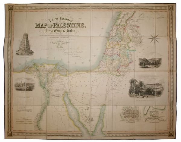
Large hand-coloured folding engraved map (ca. 103 x 82 cm). Scale ca. 1:1,000,000. In contemporary red morocco slipcase. Rare 1833 edition of a historical map of Palestine, with a part of Egypt and Arabia. This map is of particular interest for showing the principal roads and travel routes through the desert, with the old Roman road and the route of the Hajj, as well as the route taken by Eyles Irwin in 1777. Occasional browning; slipcase rubbed and bumped, but well preserved on the whole. - Cf. Röhricht (Palästina) 633 (London, 1831). Laor, Maps of the Holy Land (1839 edition). Not in Al Ankary or Al-Qasimi.
