Deliniantur in hac tabula, Orae maritimae Abexiae, freti Mecani: al Maris Rubri-Arabiae [.].
Deliniantur in hac tabula, Orae maritimae Abexiae, freti Mecani: al Maris Rubri-Arabiae [.]. | Libri antichi e moderni | Langren, H. F. Van.
Libri antichi e moderni
Langren, H. F. Van.
Deliniantur in hac tabula, Orae maritimae Abexiae, freti Mecani: al Maris Rubri-Arabiae [.].
Deliniantur in hac tabula, Orae maritimae Abexiae, freti Mecani: al Maris Rubri-Arabiae [.]. | Libri antichi e moderni | Langren, H. F. Van.
Libri antichi e moderni
Langren, H. F. Van.
9500,00 €
(Wien,
Austria)
Metodi di Pagamento
- PayPal
- Carta di Credito
- Bonifico Bancario
- Pubblica amministrazione
- Carta del Docente
Dettagli
- Autore
- Langren, H. F. Van.
- Soggetto
- Middle East, incl. Arabian Gulf: History, Travels, Falconry and Horses
- Lingue
- Inglese
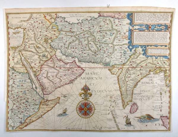
Descrizione
Copper engraving (from J. Huygen van Linschoten, Itinerario, 1596). Printed on 2 joined sheets. 385 x 535 mm. Matted. Famous map of the Arabian Sea between Cyprus and northern Sumatra from one of the ed. 1596-1644. "Probably the first detailed navigation chart printed for the Indian Ocean and the Arabian sea" (Al Ankary 148). - Tibbetts 46. Al Ankary 148f. Gole, Early Maps 8. Schilder, MCN V, p. 140 & VII, p. 220/1. Clancy 70. Clancy/R. 67 (all illustrated).
