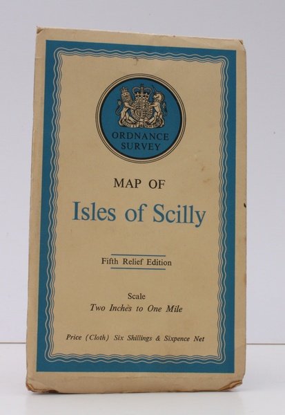
Ordnance Survey Map of Isles of Scilly. Fifth Relief Edition. Scale: Two Inches to One Mile. UNIQUE VARIANT OF THE FIRST POST-WAR OS COVER DESIGN
Libri antichi e moderni
Ordnance Survey
Ordnance Survey, Southampton,
1961
Ordnance Survey Map of Isles of Scilly. Fifth Relief Edition. Scale: Two Inches to One Mile. UNIQUE VARIANT OF THE FIRST POST-WAR OS COVER DESIGN
Libri antichi e moderni
Ordnance Survey
Ordnance Survey, Southampton,
1961
34,50 €
(Devon,
Regno Unito)
Metodi di Pagamento
- PayPal
- Carta di Credito
- Bonifico Bancario
- Pubblica amministrazione
- Carta del Docente
Dettagli
- Anno di pubblicazione
- 1961
- Autore
- Ordnance Survey
- Editori
- Ordnance Survey, Southampton
- Soggetto
- topography, cartography, maps, ordnance survey, cardiff, severn, ellis martin
- Lingue
- Inglese
Descrizione
Folding coloured map on cloth measuring 22 x 25.5 ins (approx. 56 x 65 cms) folding in 18 panels to 8.0 x 4.5 ins (approx. 20.0 x 11.5 cms); original pictorial card wrappers, a very good, bright, clean copy. UNIQUE VARIANT OF THE ELLIS MARTIN STANDARD COVER DESIGN. Martin created the 'wavy border' cover format in 1940. It it became the first OS post-war design, lasting with its various variants well into the 1960s. The Isles of Scilly Fifth Relief was first published in 1933; this is the 1961 reissue. It is a unique design variant, with blue border in long format on cream card. SCARCE, ESPECIALLY IN THIS CONDITION. Browne 96.2.b.c.