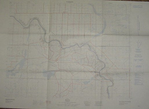
Map of Hays Alberta, West of Fourth Meridian, Scale 1:50,000
Map of Hays Alberta, West of Fourth Meridian, Scale 1:50,000 | Libri antichi e moderni | No Author
Libri antichi e moderni
No Author
Surveys and Mapping Branch, Department of Energy, Mines and - Resources,
1975
Map of Hays Alberta, West of Fourth Meridian, Scale 1:50,000
Map of Hays Alberta, West of Fourth Meridian, Scale 1:50,000 | Libri antichi e moderni | No Author
Libri antichi e moderni
No Author
Surveys and Mapping Branch, Department of Energy, Mines and - Resources,
1975
79,95 €
(Ladysmith,
Canada)
Metodi di Pagamento
- PayPal
- Carta di Credito
- Bonifico Bancario
- Pubblica amministrazione
- Carta del Docente
Dettagli
- Anno di pubblicazione
- 1975
- Luogo di stampa
- Canada
- Autore
- No Author
- Editori
- Surveys and Mapping Branch, Department of Energy, Mines and, Resources
- Edizione
- F First Edition
- Soggetto
- Map of Hays Alberta, West of Fourth Meridian, Scale 1:50, 000 Taber Municipality Newell County Bow River 25 foot contours, water bodies, roads, rail lines, Structures Pipelines Gas Wells Maps Alberta
- Descrizione
- Map
- Stato di conservazione
- Molto buono
- Lingue
- Inglese
- Prima edizione
- True
Descrizione
36" x 25.5". Indicates 25 foot contours, water bodies, roads, rail lines, structures, etc. Light wear. Unmarked. Book
