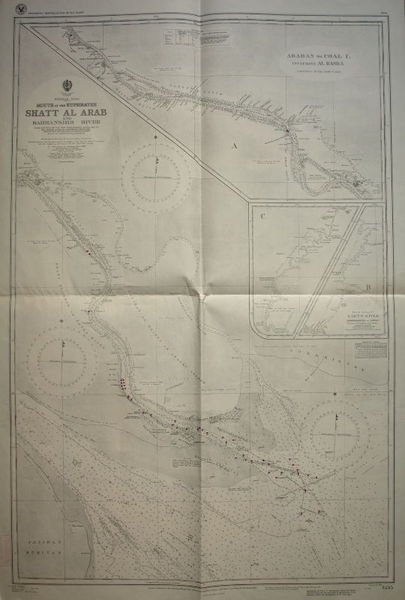
Persian Gulf. Mouth of the Euphrates. Shatt Al Arab and Bahmanshir River. From surveys by the Port Directorate, Basra, 1926-38. Khor Abdullah surveyed by Commr. H. E. F. Paine RIN, 1941-1942.
Persian Gulf. Mouth of the Euphrates. Shatt Al Arab and Bahmanshir River. From surveys by the Port Directorate, Basra, 1926-38. Khor Abdullah surveyed by Commr. H. E. F. Paine RIN, 1941-1942. | Libri antichi e moderni | [Arabian Gulf - Shatt Al Arab].
Libri antichi e moderni
[Arabian Gulf - Shatt Al Arab].
London, 1944.,
1500,00 €
(Wien,
Austria)
Metodi di Pagamento
- PayPal
- Carta di Credito
- Bonifico Bancario
- Pubblica amministrazione
- Carta del Docente
Dettagli
- Autore
- [Arabian Gulf - Shatt Al Arab].
- Editori
- London, 1944.
- Soggetto
- Middle East, incl. Arabian Gulf: History, Travels, Falconry and Horses
- Lingue
- Inglese
Descrizione
Map (67 x 98 cm). Lights and beacons highlighted in purple. Wartime reprint, “reproduced by the U.S. Hydrographic Office from British Admiralty Chart”. First issued in 1921, with changes in 1923, 1928, 1931, 1936, 1940, and 1943. - Not in Al Ankary; Al-Qasimi.
