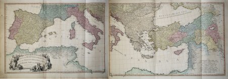
A Map of the Mediterranean Sea with the Adjacent Regions and Seas in Europe, Asia and Africa. London: Printed for W. Faden,
A Map of the Mediterranean Sea with the Adjacent Regions and Seas in Europe, Asia and Africa. London: Printed for W. Faden, | Stampe | FADEN William
A Map of the Mediterranean Sea with the Adjacent Regions and Seas in Europe, Asia and Africa. London: Printed for W. Faden,
A Map of the Mediterranean Sea with the Adjacent Regions and Seas in Europe, Asia and Africa. London: Printed for W. Faden, | Stampe | FADEN William
Metodi di Pagamento
- PayPal
- Carta di Credito
- Bonifico Bancario
- Pubblica amministrazione
- Carta del Docente
Dettagli
- Anno di pubblicazione
- 1785
- Luogo di stampa
- Londra
- Formato
- 1680 X 615
- Incisori
- FADEN William
- Descrizione
- Phillips (atlases) 6010, 6013, 6047.
Descrizione
Grande ed interessante carta del Mediterraneo pubblicata da William Faden nel "General Atlas".Si tratta di un insieme di due mappe: il foglio occidentale comprende il territorio del Portogallo, della Spagna, Italia, Maghreb e parti della Francia e dei Balcani; sono incluse le isole spagnole di Minorca, Maiorca e Ibiza insieme a Corsica, Sardegna Malta e Sicilia. Il foglio orientale comprende la parte orientale che si estende dalla Croazia ad est fino all’Iran e dalla Crimea a sud fino al delta del Nilo in Egitto; sono comprese le isole di Creta, Cipro e il Mar Nero. La Grecia e la Turchia moderne compaiono nella loro interezza (compresa l’area precedentemente nota come Kurdistan), nonché Georgia, Armenia, Giordania, Israele, Palestina, Iran, Iraq, Siria, Ucraina e Balcani. Codificata per colore in base al territorio politico, l’opera raffigurata la penisola italiana divisa in vari stati e ducati.Acquaforte, su carta vergata coeva, finemente colorata a mano in epoca, in perfetto stato di conservazione. A large map of the Mediterranean Sea by Faden's General Atlas.This is an appealing 1785 map of the Mediterranean region issued by William Faden. A set of two maps, the western sheet covers from Portugal, Spain, Italy, the Maghreb or the Barbary Coast of Africa and includes parts of France and the Balkans. The Spanish Islands of Minorca, Majorca and Ibiza are included, along with Corsica, Sardinia, Malta and Sicily. The eastern sheet extends from Croatia east as far as Iran and from Crimea south to Egypt’s Nile Delta, including the islands of Crete or Candia and Cyprus and the Black Sea. Covers the modern day Greece and Turkey in their entirety (including the area formerly known as Kurdistan), as well as Georgia, Armenia, Jordan, Israel, Palestine, Iran, Iraq, Syria, Ukraine and the Balkan nations. Color coded according to political territory, the map notes several important towns, rivers, cities, lakes, islands and mountains along with other topographic features. Depicts the Italian peninsula divided up in to various states and duchies. Jerusalem, Baghdad (Bagdad), Constantinople (the capital of the Roman Empire) and other important cities.When this map was drawn this region was dominated by the waning Ottoman hegemony. The Ottomans would nevertheless continue to exert a powerful influence on this region until the early 19th century. The Barbary Coast was a hotbed of piracy – much like the Somali Coast today. The Barbary Pirates would attack trading ships passing through narrow Gibraltar straits and western Mediterranean. Ships would be destroyed or appropriated, cargo seized and the crew and passengers enslaved. By the early 19th century, piracy in this region had become so intense that the United States launched its first major naval offensive against Tripoli. The resultant 1805 Battle of Derne later inspired a portion of the lyrics of the Mariners’ Hymn ‘To the shored of Tripoli’.This map was printed and issued by William Faden in his 1811 edition of the General Atlas. Cfr. Phillips (atlases) 6010, 6013, 6047.
