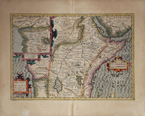
Abissinorum Sive Pretiosi Ioannis Imperiu
Abissinorum Sive Pretiosi Ioannis Imperiu | Stampe | HONDIUS Jodocus

Abissinorum Sive Pretiosi Ioannis Imperiu
Abissinorum Sive Pretiosi Ioannis Imperiu | Stampe | HONDIUS Jodocus
Metodi di Pagamento
- PayPal
- Carta di Credito
- Bonifico Bancario
- Pubblica amministrazione
- Carta del Docente
Dettagli
- Anno di pubblicazione
- 1606
- Luogo di stampa
- Amsterdam
- Formato
- 490 X 340
- Incisori
- HONDIUS Jodocus
Descrizione
Carta della porzione centrale dell'Africa, disegnata dall'importante cartografo olandese Jodocus Hondius. Realizzata con la caratteristica combinazione di precisione ed estro artistico, la mappa offre un'affascinante miscela di caratteristiche geografiche note, congetture e miti, emblematica dell'epoca di esplorazione in cui è stata creata. Si concentra sul leggendario regno del cristiano Prete Gianni. Segue lo stile cartografico di Abraham Ortelius e si basa sui viaggi dell'esploratore portoghese Francisco Alveres nel 1520, che cercava il mitico regno. La carta colloca il regno sull'Amara Mons, nella regione in cui Alveres incontrò il sovrano cristiano copto Davide II. L'inserto della regione del Congo, influenzato sempre da Ortelius, illustra i viaggi di un altro esploratore portoghese, Duarte Lopez. Il Nilo viene ricondotto alla sua sorgente nei laghi gemelli tolemaici di Zaire e Zaflan, alla base delle Montagne della Luna. Questa carta non solo rappresenta visivamente la geografia dell'Africa centrale, ma esplora anche le spedizioni storiche e i racconti mitici che hanno incuriosito gli esploratori per secoli. La carta è inserita, a partire da 1606, nell'Atlas sive Cosmographicae Meditationes de Fabrica Mundi et Fabricati figura ' di Hondius e ristampata in tutte le successive edizioni. Nel 1604, Jodocus Hondius (1563-1612) - probabilmente tramite Cornelis Claesz - acquistò le matrici in rame dell'Atlas sive cosmographicae meditationes de fabrica mundi ' di Gerard Mercator all’asta. Aggiunse circa 40 mappe, comprese nuove mappe dei continenti e importanti mappe regionali delle Americhe, prima di pubblicare una nuova edizione dell’opera, nel 1606, in concorrenza con il ' Theatrum Orbis Terrarum ' di Ortelius. Poiché molte delle mappe erano più aggiornate, la raccolta di Mercator & Hondius sostituì effettivamente il ' Theatrum ' di Ortelius. ' L’atlante del 1606 include tutte le 107 mappe dell’edizione del 1595, oltre a 37 nuove mappe, abilmente incise dallo stesso Hondius. La seconda edizione della raccolta seguì già nel 1607/08, mentre la prima edizione in un’altra lingua, il francese, fu messa sul mercato nel 1609. Apparentemente questa fu considerata come la terza edizione, perché nel 1611 apparve l'Editio Quarta, ' con un totale di 150 mappe. Dopo la morte di Jodocus Hondius (1612) la sua vedova e i suoi figli continuarono la stampa dell’atlante. Jodocus Junior ( o Jodocus II, 1594-1629) produsse diverse ristampe tra il 1613 e il 1619, sempre con le stesse 150 mappe; nel 1619 furono invece aggiunte sei nuove mappe. Dopo il 1620 la pubblicazione venne curata da Hendrick (Henricus) Hondius (1597-1651), il secondo figlio di Jodocus senior. Varie edizioni apparvero, nel 1623, 1628 e 1630. Hendrick fu il primo ad apportare dei veri cambiamenti: nell’edizione del 1628 firmò alcune mappe di Mercatore con il proprio nome. Nel 1630, quando probabilmente stava già collaborando con suo cognato Johannes Janssonius, aggiunse nove nuove carte. Incisione in rame, coloritura antica con ritocchi di colore, in eccellente stato di conservazione. Edizione francese. Bibliografia cfr. Koeman II Me 11 e Koeman II Me 13A, 1595); Van der Krogt 1:002; J. Keuning, ' The History of an Atlas, in “Imago Mundi” IV (1947) pp. 37-43; ' World Encompassed ' p. 134. Finely executed map of the central portions of Africa ' by the prominent Dutch cartographer, Jodocus Hondius. ' Hondius' map offers a captivating glimpse into the late 16th and early 17th century understanding of Africa. Crafted with Hondius's characteristic combination of precision and artistic flair, the map offers a fascinating blend of known geographical features, conjecture, and myth, emblematic of the era of exploration in which it was created. This beautifully coloured antique map of central Africa focuses on the legendary kingdom of Christian Prester John. It follows the cartography style of Ortelius and is based on the travels of Portuguese explorer Francisco Alveres in 1520, who sought the mythical kingdom. The map places Prester John's realm on ' Amara Mons, in the region where Alveres encountered the Coptic Christian ruler David II. The inset of the Congo region, influenced by Ortelius, illustrates the travels of another Portuguese explorer, Duarte Lopez. The Nile is traced to its source in the Ptolemaic twin lakes of Zaire and Zaflan, at the base of the Mountains of the Moon. This map not only visually represents central African geography but also explores historical expeditions and mythical tales that have intrigued explorers for centuries. ' Published by Henricus Hondius in ' Atlas sive Cosmographicae Meditationes de Fabrica Mundi et Fabricati figura, in 1606, and it was also part of all the following editions. In 1604, Jodocus Hondius (1563-1612) – probably trought Cornelis Claesz - bought the copperplates of Mercator’s ' Atlas sive cosmographicae meditationes de fabrica mundi ' at the auction of Gerard Jr.’s effects. He added about 40 maps, including new maps of the Continents and important regional maps of the Americas, before publishing a new edition of the Atlas, in 1606, in competition with Ortelius’ ' Theatrum Orbis Terrarum. As many of the maps were more up-to-date, the Mercator-Hondius Atlas effectively superseded Ortelius’ ' Theatrum. ' This atlas from 1606 include all 107 maps from the 1595 edition, as well as 37 new maps, skillfully engraved by Hondius, of various authors. The second edition of the Mercator-Hondius atlas followed as soon as 1607/08. The first edition in another language, French, was put on the market in 1609. Apparently this one was regarded as the third edition, because in 1611 ' Editio Quarta ' appeared with a total of 150 maps. After the death of Jodocus Hondius in 1612 his widow and sons continued the publication of the ' Atlas. ' For instance Jodocus Junior (1594-1629) produced several new editions of the ' Editio Quarta ' between 1613 and 1619, each with the same 150 maps. Finally in 1619 the last edition of this atlas followed, to which six new maps were added. After 1620 the publication of the ' Atlas ' was continued by Henricus Hondius (ca. 1596/97-1651), the second son of Jodocus senior. Various editions appeared, in 1623, 1628 and 1630. Henricus Hondius was the first to make some real changes: in the 1628 edition he provided some Mercator maps with his own name. In 1630, when he was probably already cooperating with his brother-in- law Johannes Janssonius, Henricus added nine new maps. Copper engraving, contemporary colour, in good condition. Bibliografia cfr. Koeman II Me 11 e Koeman II Me 13A, 1595); Van der Krogt 1:002; J. Keuning, ' The History of an Atlas, in “Imago Mundi” IV (1947) pp. 37-43; ' World Encompassed ' p. 134. Cfr.
