Accurater Grundriss und Prospect der…HaupStadt Stockholm
Accurater Grundriss und Prospect der…HaupStadt Stockholm | Stampe | HOMANN Johann Baptist

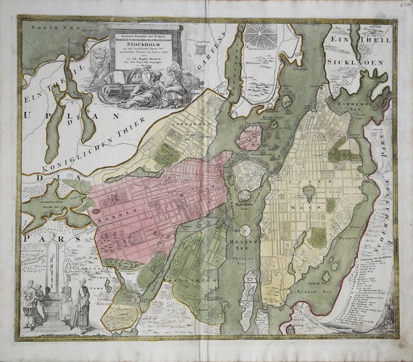

Accurater Grundriss und Prospect der…HaupStadt Stockholm
Accurater Grundriss und Prospect der…HaupStadt Stockholm | Stampe | HOMANN Johann Baptist
Metodi di Pagamento
- PayPal
- Carta di Credito
- Bonifico Bancario
- Pubblica amministrazione
- Carta del Docente
Dettagli
- Anno di pubblicazione
- 1716
- Luogo di stampa
- Norimberga
- Formato
- 590 X 500
- Incisori
- HOMANN Johann Baptist
Descrizione
Dettagliata ed ampia pianta della città di Stoccolma, arricchita da due decorativi cartigli figurati, uno per il titolo e l'altro per la scala miliare, e una legenda con 28 toponimi sulla destra. Si distinguono i singoli distretti della città e sono inserite le strade, numerosi giardini e parchi, tra cui lo zoo della città. Il cartiglio del titolo è molto decorativo con una figura femminile, un leone nascosto, armi e altri oggetti artigianali. Nella parte inferiore sinistra si trova una scala miliare, con figure in abito del periodo. In basso a destra, una legenda con punti di interesse più significativi della città. La carta fu realizzata da Homann per il suo Grosser Atlas. Johann Baptist Homann è stato un geografo e cartografo tedesco; nel 1702 fondò la sua casa editrice. Homann acquisì fama come uno dei principali cartografi tedeschi, e nel 1715 fu nominato geografo imperiale dall'imperatore Carlo VI. Nello stesso anno fu anche nominato membro dell'Accademia Prussiana delle Scienze a Berlino. Nel 1716 Homann pubblicò il suo capolavoro Grosser Atlas ueber die ganze Welt. Numerose mappe furono redatte in collaborazione con l'incisore Christoph Weigel. Homann morì a Norimberga nel 1724. Gli successe suo figlio Johann Christoph (1703-1730). L'azienda continuò dopo la sua morte come azienda degli eredi Homann, gestita da Johann Michael Franz e Johann Georg Ebersberger. Dopo successivi cambiamenti nella gestione, l'azienda si sciolse nel 1852. ' Incisione in rame in perfette condizioni. Detailed plan of Stockholm, includes an elaborate plan, 2 cartouches and a key showing 28 places. Here the individual districts of the city are distinguished and the streets, numerous gardens and parks can be located including the city Zoo. Below the bustling harbor is a compass rose in the center of Lake Mälaren. The title cartouche is very decorative with a female figure, a lurking lion, weapons and craft materials. The bottom left has a mileage scale with figures in period dress. On the bottom right is a legend with marked points of interest in the city. The map was made by Homann for his Grosser Atlas. Johann Baptist Homann was a German geographer and cartographer; in 1702 he founded his own publishing house. Homann acquired renown as a leading German cartographer, and in 1715 was appointed Imperial Geographer by Emperor Charles VI. In the same year he was also named a member of the Prussian Academy of Sciences in Berlin. In 1716 Homann published his masterpiece Grosser Atlas ueber die ganze Welt; numerous maps were drawn up in cooperation with the engraver Christoph Weigel the Elder. Homann died in Nuremberg in 1724 and was succeeded by his son Johann Christoph (1703-1730). The company carried on upon his death as Homann heirs company, managed by Johann Michael Franz and Johann Georg Ebersberger. After subsequent changes in management the company folded in 1852. Etching with fine original colour, good condition. Cfr.
