Aeneae Troiani Navigatio Ad Virgilij fex priores Aeneidos
Aeneae Troiani Navigatio Ad Virgilij fex priores Aeneidos | Stampe | ORTELIUS Abraham
Aeneae Troiani Navigatio Ad Virgilij fex priores Aeneidos
Aeneae Troiani Navigatio Ad Virgilij fex priores Aeneidos | Stampe | ORTELIUS Abraham
Metodi di Pagamento
- PayPal
- Carta di Credito
- Bonifico Bancario
- Pubblica amministrazione
- Carta del Docente
Dettagli
- Anno di pubblicazione
- 1594
- Luogo di stampa
- Anversa
- Formato
- 500 X 348
- Incisori
- ORTELIUS Abraham
- Soggetto
- Carte Storiche
Descrizione
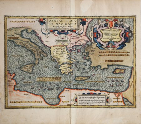
Splendida carta storico-geografica raffigurante il viaggio di Enea, che dopo la distruzione di Troia vagò nel Mediterraneo per 7 anni con una flotta di 20 navi. Opera pubblicata nel ' Parergon ' di Abraham Ortelius. Esemplare dalla rara edizione italiana del Theatrum Orbis Terrarum stampata ad Anversa da Jean Baptiste Vrients nel 1608 e quindi nel 1612. Esemplare nel secondo stato di tre descritto da Van den Broecke: nel 1601 furono aggiunti i toponimi "Pallene" e "Aphrodisium" a sinistra di Lemnos, e "Nesos" nel Peloponneso. Titolo: AENEAE TROIA:|NI NAVIGATIO | "Ad Virgilii sex priores Æneidos". Cartiglio in alto a destra: DOCTRINA ET HVMANITATE | CELEBRI DÑO BALTHASARO | ROBIANO, R.P. ANT, THE:|SAVRARIO, VIRO ANIMI | CORPORISQ DOTIBVS | ORNATISS. | Ab. Ortelius veteris amicitiæ memor | dedicabat. [In memoria della sua amicizia, Abraham Ortelius dedicò questa carta all'onorevole e famoso Balthasar Robianus della repubblica di Anversa, noto per la sua erudizione e le sue qualità spirituali e culturali, tesoriere e onorato per le sue doti fisiche e mentali]. Al centro a destra: "Cum priuilegio Imperatorio, Regio, | et Cancellariæ Brabantiæ, decennali. | 1594". In basso a sinistra: "Septima post Troiæ excidium iam vertitur æstas: | Cum freta, cum terras omnes, tot inhospita saxa, | Syderaque emensæ ferimur: dum per MARE MAGNVM | Italiam sequimur fugientem, & volvimur undis". [Nel settimo anno dopo la perdita di Troia l'estate è giunta al termine; tanti stretti abbiamo visto, tante terre, rocce così inospitali, che ora siamo impressionati dalle immense stelle. Seguiamo l'Italia in fuga attraverso il grande mare e siamo sballottati dalle onde]. Dopo la distruzione di Troia, Æneas avrebbe vagato per i mari per sette anni, come descritto tra l'altro negli scritti di Senofonte, Ovidio e Licofrone, ma soprattutto da Vergilio nella sua Æneas. Nel corso di queste peregrinazioni, delle venti navi originarie ne rimasero solo sette, come si può vedere in questa mappa nella parte inferiore sinistra del mare. Circa una decade dopo la pubblicazione del “moderno” Theatrum Orbis Terrarum, Ortelius rispose alle “preghiere di amici e studiosi di storia antica, sacra e profana” e compilò una serie di mappe di soggetto biblico e classico, quasi tutte disegnate da lui. Intitolò l’opera “Parergon theatri”, ovvero “aggiunta, appendice, del Theatrum”, ma al tempo stesso anche complementare al Theatrum: il Paregon theatri forniva per il mondo antico lo stesso materiale che Ortelius aveva fornito per il mondo moderno con il Theatrum: carte geografiche. Lo spirito del Parergon è tutto riassunto nel motto historiae oculus geographia riportato sul frontespizio: la geografia è l’occhio della storia. Le mappe del mondo antico avevano lo scopo di “rendere più chiari gli storici antichi e i poeti”. Le mappe del Paregon sono di tre tipologie: antiche regioni; carte letterarie e carte bibliche. Come sottolinea Koeman “il Parergon deve essere considerato come lavoro personale di Ortelius. Per quest'opera, infatti, diversamente dal Theatrum, non copiò le mappe di altri cartografi, ma ne disegnò lui stesso di nuove ed originali. Riprese luoghi, regioni e territori delle civiltà classiche illustrandone e spiegandone la storia, una materia molto vicina al suo cuore. Le mappe e le lastre del Parergon devono essere valutate come le più importanti incisioni che rappresentano il diffuso interesse per la geografia classica nel XVI secolo”. “La carta realizzata da Ortelius per descrivere i luoghi attraversati da Enea dopo la sua fuga dalla città di Troia ormai in fiamme, prende in considerazione il Mediterraneo orientale e quello centrale. Enea fuggi da Ilio portando con sé i Penati, il figlio Ascanio e, sulle spalle, il padre Anchise; con i Troiani superstiti salpò con venti navi da Antandro per approdare successivamente a Delo, in Tracia, poi sull'isola di Creta, da qui in Sicilia, dove Anchise trover. Splendid historical map of the Æneas travels; after the destruction of Troy, Æneas is reported to have roamed the seas for seven years. Map ' published in Abraham Ortelius' Parergon. Example from the rare Italian edition of Theatrum Orbis Terrarum printed in Antwerp by Jean Baptiste Vrients in 1608 and then in 1612. Example of the second state of three: in 1601 the place names "Pallene" and "Aphrodisium" were added on left of Lemnos, and "Nesos" was added on the Peloponnesos. Title: AENEAE TROIA:|NI NAVIGATIO | "Ad Virgilii sex priores Æneidos. [The sea journey of Troian Æneas, after the first six books of the Æneas by Vergilius]. Cartouche top right: DOCTRINA ET HVMANITATE | CELEBRI DÑO BALTHASARO | ROBIANO, R.P. ANT, THE:|SAVRARIO, VIRO ANIMI | CORPORISQ DOTIBVS | ORNATISS. | "Ab. Ortelius veteris amicitiæ memor | dedicabat. [In memory of his friendship, Abraham Ortelius dedicated this map to the honourable and famous Balthasar Robianus from the republic of Antwerp, known for his learnedness and spiritual and cultural qualities, treasurer and honoured for his physical and mental talents]. Middle right: "Cum priuilegio Imperatorio, Regio, | et Cancellariæ Brabantiæ, decennali. | 1594". [With an Imperial, Royal and Council of Brabant privilege for ten years, 1594]. Lower left: "Septima post Troiæ excidium iam vertitur æstas: | Cum freta, cum terras omnes, tot inhospita saxa, | Syderaque emensæ ferimur: dum per MARE MAGNVM | Italiam sequimur fugientem, & volvimur undis". [In the seventh year after the loss of Troy the summer has come to an end; so many straits we have seen, so many lands, such inhospitable rocks, that now we are impressed by the immense stars. We follow fleeing Italy through the large sea, and are tossed around by the waves]. After the destruction of Troy, Æneas is reported to have roamed the seas for seven years, as described among others in the writings of Xenophon, Ovidius and Lycophron, but most extensively by Vergilius in his Æneas. In the course of these wanderings, only seven of the original twenty ships remained, as may be seen on this map in the lower left part of the sea. The Parergon is the first historical atlas ever published. It was initially conceived by Ortelius as an appendix to his Theatrum Orbis Terrarum but given the considerable success of these historical maps it later became an independent work and remained the main source of all similar works throughout the seventeenth century. Koeman wrote: “This atlas of ancient geography must be regarded as a personal work of Ortelius. For this work he did not, as in the Theatrum, copy other people's maps but drew the originals himself. He took many places and regions from the lands of classical civilization to illustrate and clarify their history, a subject very close to his heart. The maps and plates of the Parergon have to be evaluated as the most outstanding engravings depicting the wide-spread interest in classical geography in the 16th century." The Theatrum Orbis Terrarum, which is considered the first true modern "Atlas". The work was published in 7 languages and 36 editions, for which - in 1570 - Ortelius obtained the privilege, a kind of copyright that prevented other cartographers from publishing his works. The Theatrum represented the most advanced work of cartographic description. Ortelius collected in it the geographical and cartographic knowledge of his time, proposing in 147 spectacular engraved plates the most faithful image of the world then known and, in some extraordinary "historical maps", regions and routes taken from literature, mythology, tradition. Example with magnificent contemporary coloring, paper slightly browned, otherwise in excellent condition. Bibliografia Cfr. L. Bagrow, A. Ortelli Catalogus Cartographorum; cfr. C. Koeman, Atlantes Neerlandici; Peter H. Meurer, Fontes Cartographici Orteliani 32p; M. Van den Broecke, Ortelius Atlas Maps, n. 223 II/III; Van der Krogt, Koeman’s A. Cfr.
