Anchorages in the New Hebrides Islands
Anchorages in the New Hebrides Islands | Stampe | Admiralty Charts, Admiralty Charts
Anchorages in the New Hebrides Islands
Anchorages in the New Hebrides Islands | Stampe | Admiralty Charts, Admiralty Charts
Metodi di Pagamento
- PayPal
- Carta di Credito
- Bonifico Bancario
- Pubblica amministrazione
- Carta del Docente
Dettagli
- Formato
- mm 610x483
- Edizione
- '900
- Incisori
- Admiralty Charts
- Soggetto
- Tanna Island - New Hebrides
- Disegnatori
- Admiralty Charts
- Lingue
- Italiano
Descrizione
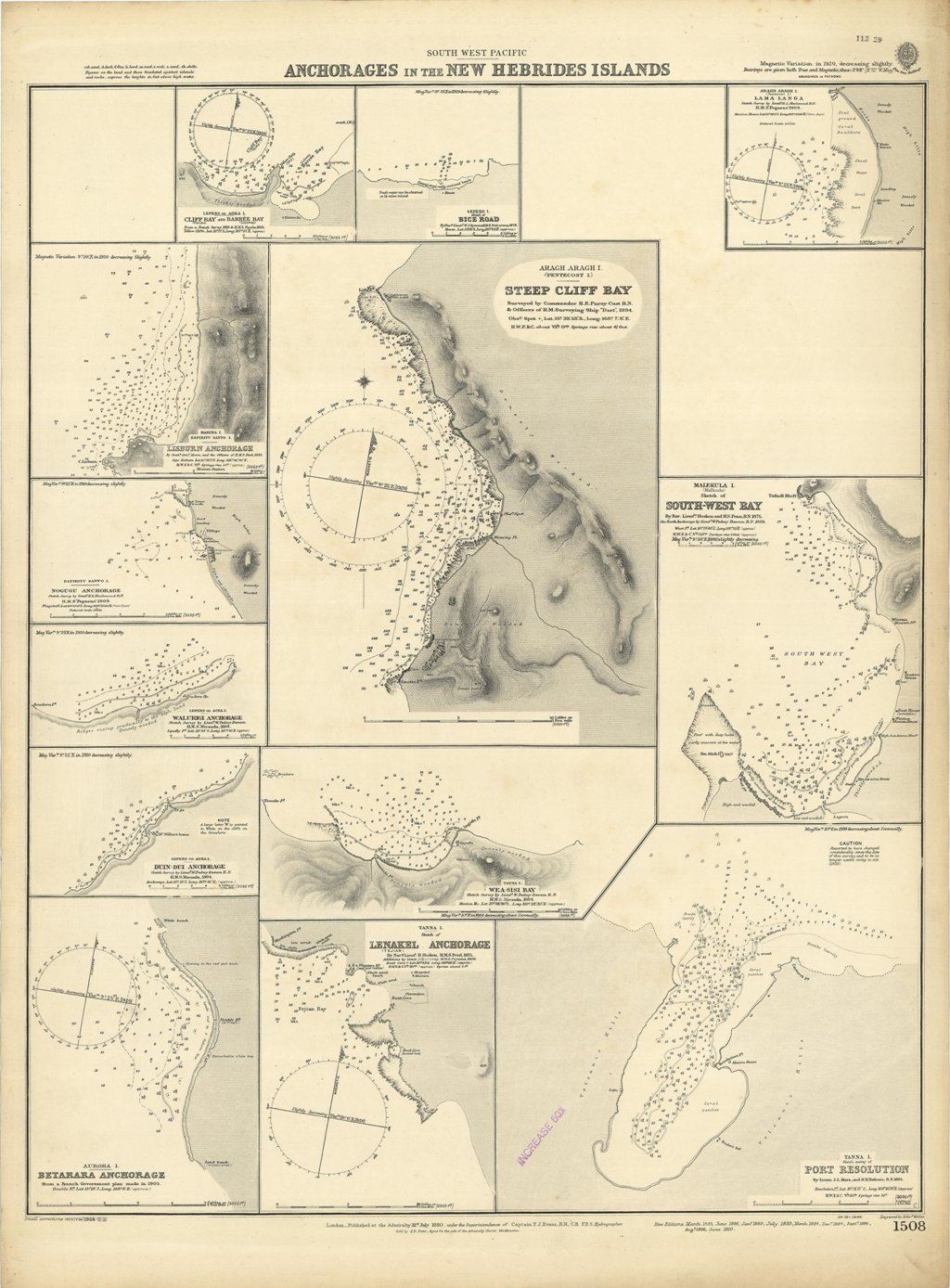
Ancient and original map of Anchorages in the New Hebrides Islands In the left side of the chart insert of Cliff Bay and Barree Bay, From a French Survey 1885 & H.M.S. Psyche 1905, Lisburn Anchorage By Lieut. Com. Moore, and the Officers of H.M.S. "Dart" 1883, Nogugu Anchorage Sketch Survey by Lieut. H.L. Haslewood H.M.S. "Pegasus", 1909, Walurigi Anchorage Sketch Survey by Lieut. W. Pudsey-Dawson H.M.S. Miranda, 1884, Dun-Dui Anchorage Sketch Survey by Lieut. W. Pudsey-Dawson H.M.S. Miranda, 1884, Betarara Anchorage From a French Government Plan made in 1905. In the middle of the chart insert of Bice Road, By Nav. Lieut. W.J. Symons, H.M.S. Wolverene, 1878, Steep Cliff Bay Surveyed by Commander H.E. Purey-Cust & Officers of H.M. Surveying Ship "Dart", 1894, Wea-Sisi Bay Sketch Survey by Lieut. W. Pudsey-Dawson H.M.S. Miranda, 1884, Lenakel Anchorage By Nav. Lieut. H. Hosken, H.M.S. Pearl, 1875 Additions by Lieut. J.B.L. Murray, H.M.S. Pegasus, 1906. In the right side of the chart insert of Lama Langa Sketch Survey by Lieut. H.L. Haslewood H.M.S. "Pegasus" 1909, South-West Bay By Nav. Lieut. Hosken and H.S. Penn, 1875. the North Anchorage by Lieut. W. Pudsey-Dawson, 1884, Port Resolution By Lieuts J.L. Marx, and H.H. Torlesse, 1885. London Published at the Admiralty, 31st July 1880, under the Superintendence of Captain F.J. Evans, Hydrographer. Small corrections: 1928. Autore: Admiralty Charts. Luogo: Tanna Island - New Hebrides. Anno: '900. Tecnica: incisione. Dimensioni: 610x483 mm
Anno di pubblicazione: '900
