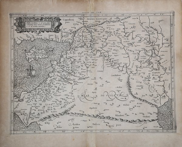
ASIAE IIII TAB.
ASIAE IIII TAB. | Stampe | MERCATOR (Kremer) Gerard

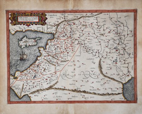
ASIAE IIII TAB.
ASIAE IIII TAB. | Stampe | MERCATOR (Kremer) Gerard
Metodi di Pagamento
- PayPal
- Carta di Credito
- Bonifico Bancario
- Pubblica amministrazione
- Carta del Docente
Dettagli
- Anno di pubblicazione
- 1578
- Luogo di stampa
- Colonia
- Formato
- 475 X 350
- Incisori
- MERCATOR (Kremer) Gerard
- Lingue
- Italiano
Descrizione
Mappa della Terra Santa, Cipro e Siria. Mercatore ha ricreato la concezione di Tolomeo di queste regioni introducendo la finezza e la precisione del proprio stile cartografico. La mappa presenta le regioni così come erano intese nel mondo antico, con il fiume Giordano, il Mar Morto, la costa mediterranea e città importanti come Gerusalemme e Antiochia chiaramente rappresentate. Allo stesso modo, anche l'isola di Cipro, un luogo importante nelle antiche rotte commerciali del Mediterraneo, e la Siria, crocevia di diverse antiche civiltà, sono ricche di dettagli. Mappa tratta dal ' Cl. Ptolemaei Alexandrini, Geographiae Libri Octo, ' pubblicata prima a Colonia da Gottfried von Kempen (1578) e poi ristampata dallo stesso editore nel 1584 (Van der Krogt 1, 502) e poi da Isaac Elsevier per il ' Theatrum Geographiae veteris ' di Petrus Bertius (Leyden 1618). Di tutte le edizioni di Tolomeo, quella di Gerard Kremer (Mercatore), pubblicata nel 1578, e forse tecnicamente la più bella. A questo punto la ' Geografia ' di Tolomeo perdeva però ogni pretesa di “attualità”, laddove lo scopo di Mercatore era quello di produrre un atlante del mondo classico che servisse da complemento al suo atlante moderno (per tale ragione egli aveva tentato di recuperare la forma originale dell’atlante tolemaico, scartandone le moderne accrezioni). L'interpretazione di Mercatore del testo tolemaico, per le 28 carte che illustrano la sua ' Geographia ' è stata, quindi, una delle più veritiere. Egli aveva passato 13 anni a ricercare, disegnare e incidere le carte, rinunciando anche alla pubblicazione delle sue carte “moderne”. Questo esemplare proviene dal ' Theatrum Geographia Veteris ' di Petrus Bertius edita a Leida nel 1618, che combina il Tolomeo di Mercator, le 8 tavole del Moretus per rappresentare la ' Tabula Peutingeriana ' e 14 mappe storiche delle regioni d'Europa derivate dal ' Parergon ' di Ortelius. Acquaforte su rame finemente colorata a mano, in buone condizioni. ' Map of the Holy Land, Cyprus, and Syria. Mercator recreated Ptolemy's conception of these regions while introducing the finesse and precision of his own cartographic style. The map features the regions as they were understood in the ancient world, with the Jordan River, Dead Sea, Mediterranean coast, and prominent cities like Jerusalem and Antioch clearly depicted. Similarly, the island of Cyprus, an important location in ancient Mediterranean trade routes, and Syria, the crossroads of several ancient civilizations, are also intricately detailed. Taken from the ' Cl. Ptolemaei Alexandrini, Geographiae Libri Octo, ' first published in Cologne by Gottfried von Kempen (1578) and then reprinted by the same publisher in 1584 (Van der Krogt 1, 502) and then by Isaac Elsevier for the Petrus Bertius’ ' Theatrum Geographiae veteris ' (Leyden 1618). Mercator's interpretation of the 28 Ptolemaic text was possibly one of the truest undertaken up until that time. He had spent 13 years researching, drawing and engraving the maps at much commercial sacrifice to himself, having seen Ortelius's ' Theatrum ' and De Jodes ' Speculum ' published, to become both technical and commercial successes. In later life he devoted himself to his edition of the maps in Ptolemy's ' Geographia, reproduced in his own engraving as nearly as possible in their original form. This example comes from the ' Theatrum Geographia Veteris ' of Petrus Bertius published in Leiden in 1618, which combines Mercator's Ptolemy, the 8 plates of Moretus to represent the ' Tabula Peutingeriana ' and 14 historical maps of the regions of Europe derived from the ' Parergon ' of Ortelius. Copperplate with fine later hand colour, in good condition. Cfr. Koeman Me 5; Nordenskiold 234; Phillips, P.L. (Atlases) 384; Shirley BL T.Ptol-11a & 11k; Van der Krogt, P. (Atlantes) 1:501.
