Asiae VIII Tab.
Asiae VIII Tab. | Stampe | MERCATOR (Kremer) Gerard
Asiae VIII Tab.
Asiae VIII Tab. | Stampe | MERCATOR (Kremer) Gerard
Metodi di Pagamento
- PayPal
- Carta di Credito
- Bonifico Bancario
- Pubblica amministrazione
- Carta del Docente
Dettagli
- Anno di pubblicazione
- 1578
- Luogo di stampa
- Amsterdam
- Formato
- 410 X 350
- Incisori
- MERCATOR (Kremer) Gerard
Descrizione
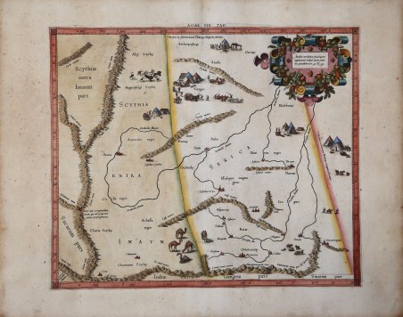
Carta della Cina occidentale e di parte della Mongolia che mostra le regioni note fin dall'epoca tolemaica come Serica e Scizia orientale. La Scizia e la Serica erano entrambi imperi durante l'antichità classica dell'Europa, con la Scizia che formava un impero nomade sciolto che si estendeva dall'Europa orientale fino ai confini della Cina. Di Serica si sa meno, ma si pensa che fosse la parte della Cina raggiunta dalla via della seta via terra, a differenza della Sinae, che era la parte della Cina più facilmente raggiungibile via mare. Gran parte delle conoscenze presentate sulla mappa rimangono tolemaiche. Le città, le montagne e i fiumi indicati sono tutti originari di una proiezione tolemaica, qui aggiornata per essere localizzata sulla proiezione rettangolare di Mercatore. Bisognerà attendere il XIX secolo perché queste regioni poco visitate vengano mappate in modo estensivo dagli europei. Mappa tratta dal ' Cl. Ptolemaei Alexandrini, Geographiae Libri Octo, ' pubblicata prima a Colonia da Gottfried von Kempen (1578) e poi ristampata dallo stesso editore nel 1584 (Van der Krogt 1, 502) e poi da Isaac Elsevier per il ' Theatrum Geographiae veteris ' di Petrus Bertius (Leyden 1618). Di tutte le edizioni di Tolomeo, quella di Gerard Kremer (Mercatore), pubblicata nel 1578, e forse tecnicamente la più bella. A questo punto la ' Geografia ' di Tolomeo perdeva però ogni pretesa di “attualità”, laddove lo scopo di Mercatore era quello di produrre un atlante del mondo classico che servisse da complemento al suo atlante moderno (per tale ragione egli aveva tentato di recuperare la forma originale dell’atlante tolemaico, scartandone le moderne accrezioni). L'interpretazione di Mercatore del testo tolemaico, per le 28 carte che illustrano la sua ' Geographia ' è stata, quindi, una delle più veritiere. Egli aveva passato 13 anni a ricercare, disegnare e incidere le carte, rinunciando anche alla pubblicazione delle sue carte “moderne”. Questo esemplare proviene dal ' Theatrum Geographia Veteris ' di Petrus Bertius edita a Leida nel 1618, che combina il Tolomeo di Mercator, le 8 tavole del Moretus per rappresentare la ' Tabula Peutingeriana ' e 14 mappe storiche delle regioni d'Europa derivate dal ' Parergon ' di Ortelius. Acquaforte, finemente colorata a mano, in buone condizioni. ' Mercator's map of western China, showing the regions known since Ptolemaic times as Serica and eastern Scythia. Scythia and Serica were both empires during Europe's classical antiquity, with Scythia forming a loose nomadic empire stretching from Eastern Europe to the edge of China. Less is known about Serica, but it is most commonly thought that this was the part of China reached by the overland silk route, in contrast to Sinae, which was the part of China more easily reached by sea. Much of the knowledge presented on the map remains Ptolemaic. The cities, mountains, and rivers shown are all originally from a Ptolemaic projection, updated here to be located on Mercator's rectangular projection. It would take well into the 19th century for these little-visited regions to be mapped extensively by Europeans. ' Map taken from the ' Cl. Ptolemaei Alexandrini, Geographiae Libri Octo, ' first published in Cologne by Gottfried von Kempen (1578) and then reprinted by the same publisher in 1584 (Van der Krogt 1, 502) and then by Isaac Elsevier for the Petrus Bertius’ ' Theatrum Geographiae veteris ' (Leyden 1618). Mercator's interpretation of the 28 Ptolemaic text was possibly one of the truest undertaken up until that time. He had spent 13 years researching, drawing and engraving the maps at much commercial sacrifice to himself, having seen Ortelius's ' Theatrum ' and De Jodes ' Speculum ' published, to become both technical and commercial successes. In later life he devoted himself to his edition of the maps in Ptolemy's ' Geographia, reproduced in his own engraving as nearly as possible in their original form. This example comes from the ' Theatrum Geographia Veteris ' of Petrus Bertius published in Leiden in 1618, which combines Mercator's Ptolemy, the 8 plates of Moretus to represent the ' Tabula Peutingeriana ' and 14 historical maps of the regions of Europe derived from the ' Parergon ' of Ortelius. Copperplate with fine later hand colour, in good condition. ' Cfr.
