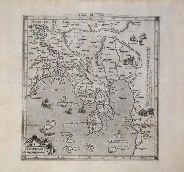
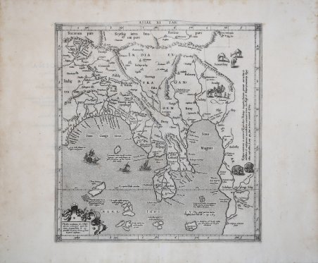
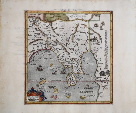
ASIAE XI TAB:
ASIAE XI TAB: | Stampe | MERCATOR (Kremer) Gerard

ASIAE XI TAB:
ASIAE XI TAB: | Stampe | MERCATOR (Kremer) Gerard
Metodi di Pagamento
- PayPal
- Carta di Credito
- Bonifico Bancario
- Pubblica amministrazione
- Carta del Docente
Dettagli
- Anno di pubblicazione
- 1578
- Luogo di stampa
- Colonia
- Formato
- 332 X 352
- Incisori
- MERCATOR (Kremer) Gerard
Descrizione
Bella mappa dell'India, del Gange e di parte dell'Asia. L'Oceano Indiano è ornato con un cartiglio decorativo con il titolo, una rosa dei venti e diversi velieri. Sulla terra sono ben visibili cammelli, nomadi ed elefanti. Riflette l'antica credenza in una terra chiusa nell'Oceano Indiano e raffigura l'India e la massa terrestre a sud e ad ovest della Cina come era percepita da molti cartografi dell'epoca. La mappa copre una vasta area che parte dal fiume Gange a ovest, estendendosi fino alla Cina, alla Birmania, al Vietnam e al Mar Cinese. Si estende dalle montagne dell'Himalaya a nord-sud fino alla punta della penisola malese e di nuovo a ovest, suggerendo l'opinione di molti, a cominciare da Tolomeo, che l'Oceano Indiano fosse senza sbocco sul mare. Sono raffigurati numerosi sistemi fluviali e catene montuose e molte città sono nominate. Mappa tratta dal ' Cl. Ptolemaei Alexandrini, Geographiae Libri Octo, ' pubblicata prima a Colonia da Gottfried von Kempen (1578) e poi ristampata dallo stesso editore nel 1584 (Van der Krogt 1, 502) e poi da Isaac Elsevier per il ' Theatrum Geographiae veteris ' di Petrus Bertius (Leyden 1618). Di tutte le edizioni di Tolomeo, quella di Gerard Kremer (Mercatore), pubblicata nel 1578, e forse tecnicamente la più bella. A questo punto la ' Geografia ' di Tolomeo perdeva pero ogni pretesa di “attualità”, laddove lo scopo di Mercatore era quello di produrre un atlante del mondo classico che servisse da complemento al suo atlante moderno (per tale ragione egli aveva tentato di recuperare la forma originale dell’atlante tolemaico, scartandone le moderne accrezioni). L'interpretazione di Mercatore del testo tolemaico, per le 28 carte che illustrano la sua ' Geographia ' è stata, quindi, una delle più veritiere. Egli aveva passato 13 anni a ricercare, disegnare e incidere le carte, rinunciando anche alla pubblicazione delle sue carte “moderne”. Questo esemplare proviene dal ' Theatrum Geographia Veteris ' di Petrus Bertius edita a Leida nel 1618, che combina il Tolomeo di Mercator, le 8 tavole del Moretus per rappresentare la ' Tabula Peutingeriana ' e 14 mappe storiche delle regioni d'Europa derivate dal ' Parergon ' di Ortelius. Acquaforte, finemente colorata a mano, in ottime condizioni. ' Beautiful map of Indochina, the Ganges, and part of Asia. ' The stipled sea is is adorned with a decorative cartouche, compass rose and several sailing ships. On land are Bactrian camels, nomads, and well-engraved elephants. ' ' Reflecting the ancient belief in a land locked Indian Ocean. Based on the work of Ptolemy depicts India and the land mass south and westward from China as it was perceived by many cartographers at the time. The map covers a vast area starting from the Ganges River in the west, extending to China, Burma, Vietnam and the China Sea. It extends from the Himalaya Mountains in the north south to the tip of the Malay Peninsula and back to the west, suggesting the view held by many, beginning with Ptolemy, that the Indian Ocean was landlocked. A number of river systems and mountain ranges are depicted and many cities are named. Map taken from the ' Cl. Ptolemaei Alexandrini, Geographiae Libri Octo, ' first published in Cologne by Gottfried von Kempen (1578) and then reprinted by the same publisher in 1584 (Van der Krogt 1, 502) and then by Isaac Elsevier for the Petrus Bertius’ ' Theatrum Geographiae veteris ' (Leyden 1618). Mercator's interpretation of the 28 Ptolemaic text was possibly one of the truest undertaken up until that time. He had spent 13 years researching, drawing and engraving the maps at much commercial sacrifice to himself, having seen Ortelius's ' Theatrum ' and De Jodes ' Speculum ' published, to become both technical and commercial successes. In later life he devoted himself to his edition of the maps in Ptolemy's ' Geographia, reproduced in his own engraving as nearly as possible in their original form. This example comes from the ' Theatrum Geographia Veteris ' of Petrus Bertius published in Leiden in 1618, which combines Mercator's Ptolemy, the 8 plates of Moretus to represent the ' Tabula Peutingeriana ' and 14 historical maps of the regions of Europe derived from the ' Parergon ' of Ortelius. Copperplate with fine later hand colour, in good condition. Cfr.
