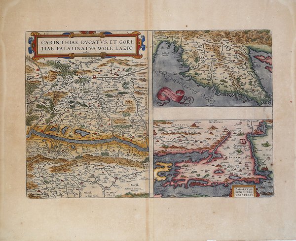
Carinthiae Dvcatvs, et Goritiae Palatinatvs, Wolf. Lazio
Carinthiae Dvcatvs, et Goritiae Palatinatvs, Wolf. Lazio | Stampe | ORTELIUS Abraham


Carinthiae Dvcatvs, et Goritiae Palatinatvs, Wolf. Lazio
Carinthiae Dvcatvs, et Goritiae Palatinatvs, Wolf. Lazio | Stampe | ORTELIUS Abraham
Metodi di Pagamento
- PayPal
- Carta di Credito
- Bonifico Bancario
- Pubblica amministrazione
- Carta del Docente
Dettagli
- Anno di pubblicazione
- 1570
- Luogo di stampa
- Anversa
- Formato
- 490 X 330
- Incisori
- ORTELIUS Abraham
- Descrizione
- M. Van den Broecke "Ortelius Atlas Maps" (2011), n. 143.
Descrizione
Tre carte in un foglio tratto dal Theatrum Orbis Terrarum di Ortelius, raffiguranti la Carinzia, L'Istria e il Ducato di Zara. Le mappe derivano da Wolfgang Latius e Pietro Coppo. Il ' Theatrum Orbis Terrarum ' è considerato il primo vero “atlante” moderno. L’opera fu pubblicata in 7 lingue e 36 edizioni, per il quale – nel 1570 - Ortelius ottenne il ' privilegio, ovvero una sorta di diritto d'autore che impediva ad altri cartografi di pubblicare i propri lavori. Il ' Theatrum ' rappresentava il lavoro più avanzato del lavoro della descrizione cartografica. L’Ortelius vi raccolse il sapere geografico e cartografico del suo tempo, proponendo in 147 spettacolari tavole incise l’immagine più fedele del mondo allora conosciuto e, in alcune straordinarie “carte storiche”, regioni e itinerari tratti dalla letteratura, dalla mitologia, dalla tradizione. Ortelius fu anche il primo a citare le fonti, menzionando i nomi dei cartografi nel “catalogus auctorum”. Dal 1598 al 1612 le edizioni postume del ' Theatrum ' furono realizzate dal suo collaboratore Johannes Baptiste Vrients. Incisione in rame, eccellente coloritura, in ottimo stato di conservazione. Nice set of three maps on a single sheet, including the region around Villach on the Dravus River, the Gulf of Trieste and Quernero and the region around Zara and Sebenico. Very detailed regional maps, one of which even shows bridges across the river. A gorgeous full color example, with wide margins. After Wolfgang Latius & Pietro Coppo. ' Map taken from the ' Theatrum Orbis Terrarum, which is considered the first true modern "Atlas". The work was published in 7 languages and 36 editions, for which - in 1570 - Ortelius obtained the privilege, a kind of copyright that prevented other cartographers from publishing his works. The ' Theatrum ' represented the most advanced work of cartographic description. Ortelius collected in it the geographical and cartographic knowledge of his time, proposing in 147 spectacular engraved plates the most faithful image of the world then known and, in some extraordinary "historical maps", regions and routes taken from literature, mythology, tradition. Ortelius was also the first to cite sources, mentioning the names of cartographers in the "catalogus auctorum". From 1598 to 1612 the posthumous editions of the ' Theatrum ' were made by his collaborator Johannes Baptiste Vrients. Copper engraving, fine coloring, in good condition. Cfr. M. Van den Broecke "Ortelius Atlas Maps" (2011), n. 143.
