Carte de la Barbarie le la Nigritie et de la Guinée…
Carte de la Barbarie le la Nigritie et de la Guinée… | Stampe | OTTENS Reiner & Joshua

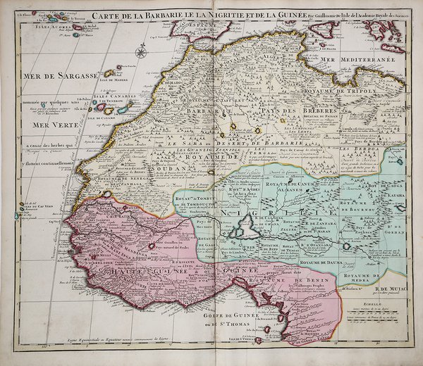
Carte de la Barbarie le la Nigritie et de la Guinée…
Carte de la Barbarie le la Nigritie et de la Guinée… | Stampe | OTTENS Reiner & Joshua
Metodi di Pagamento
- PayPal
- Carta di Credito
- Bonifico Bancario
- Pubblica amministrazione
- Carta del Docente
Dettagli
- Anno di pubblicazione
- 1707
- Luogo di stampa
- Amsterdam
- Formato
- 580 X 490
- Incisori
- OTTENS Reiner & Joshua
- Descrizione
- Cf Norwich, O.I. Norwich's maps of Africa (2nd ed.), map 317 (1700-1712 ed.)
Descrizione
Dettagliata mappa dell'Africa nord-occidentale, pubblicata da Guillaume De L'Isle, qui nella ristampa della tipografia di Reine e Joshua Ottens.La carta si estende dal Regno di Tripoli e dal Mediterraneo fino al Golfo di Guinea e al fiume Gabon, con dettagli notevoli. Include le Isole Canarie, Madeira e Capo Verde.Di tratta di una delle mappe più dettagliate e scientificamente accurate della regione pubblicate all'inizio del XVIII secolo.Guillaulme de l’Isle è il figlio e pupillo del famoso astronomo e cartografo francese Jean Dominique Cassini, con il quale si dedicò ad importanti studi sul calcolo delle longitudini.Le carte del de l’Isle sono caratterizzate dall’estrema precisione e da un’accuratezza della toponimia, e sebbene molto precise conservano il fascino e l’eleganza della storia e furono la base della successiva cartografia anche in Olanda e in Italia.La tipografia Covens e Mortier acquisì molto del materiale cartografico del De L’Isle, forse anche perché Mortier era di origine francese. La carta dell’isola di Ceylon dimostra la grande qualità della cartografia del De L’Isle, basata su informazioni che arrivavano dai viaggi della Compagnia delle Indie.Incisione in rame, coloritura coeva, in ottime condizioni. Detailed map of Northwestern Africa, published by Guillaume De L'Isle, the French Royal Mapmaker.Published in Amsterdam by Reiner & Joshua Ottens nel 1745 circa.Extends from the Kingdom of Tripoli and the Mediterranean to the Gulf of Guinea and the Gabon River, with remarkable detail throughout. Includes the Canary Islands, Madeira and the Cape Verdes.One of the most detailed and scientifically accurate maps of the region published at the beginning of the 18th Century.Guillaume de l'Isle (1675-1726) was the son and pupil of the cartographer Jean Dominique Cassini, who, among other important contributions, aligned the study of astronomy to the study of geography. Under Cassini's direction, observations were made from locations all over the world that enabled longitudinal calculations to be made with much greater accuracy. De l'Isle carried on this exacting work with remarkable dedication and integrity, constantly revising and improving his maps. While precision was his primary goal, his maps are invariably elegant and attractive. Jean (Johannes) Covens and Corneille (Cornelius) Mortier were brothers-in-law, who carried on the book publishing business established by Pierre Mortier in Amsterdam in 1685. Pierre Mortier's company owed much of its success to his access to French publishers, whose publications he re-issued in handsome editions. The elder Mortier died in 1711; his wife continued the firm until she died in 1719. In 1721, Covens and Mortier formed a partnership, Covens having married Agatha Mortier in the same year. They continued the business by publishing enlarged editions of Sanson, Jaillot, and De L'Isle, as well as some of the later Dutch cartographical masters such as De Wit and Allard, and of course Pierre Mortier.This map is from an edition of De L'Isle entitled, Atlas Nouveau, Contenant Toutes Les Parties Du Monde, Ou sont exactement Remarquées les Empires, Monarchies, Royaumes, Etats, Republiques &c. Par Guillaume de l'Isle. Premier Géographe de sa Majesté. It delineates the island in great detail. At the time the map was made, the coastal areas were ruled by the Dutch East Indian Company, who were undoubtedly responsible for the soundings indicated around the island and for mapping the roads depicted. Copper engraving, contemporary colour, in perfect condition. Cfr. Cf Norwich, O.I. Norwich's maps of Africa (2nd ed.), map 317 (1700-1712 ed.)
