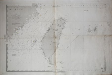
Carte de la Mer de Chine, Detroit de Formose
Carte de la Mer de Chine, Detroit de Formose | Stampe | Dépôt des cartes et plans de la Marine
Carte de la Mer de Chine, Detroit de Formose
Carte de la Mer de Chine, Detroit de Formose | Stampe | Dépôt des cartes et plans de la Marine
Metodi di Pagamento
- PayPal
- Carta di Credito
- Bonifico Bancario
- Pubblica amministrazione
- Carta del Docente
Dettagli
- Anno di pubblicazione
- 1873
- Luogo di stampa
- Parigi
- Formato
- 990 X 650
- Incisori
- Dépôt des cartes et plans de la Marine
Descrizione
Grande carta nautica di Taiwan, conosciuta anche come Isola di Formosa, realizzata da Ferdinand Antoine Jules de la Roche-Poncié nel 1853. La carta è centrata su Taiwan, ma include parti del Fujian, in Cina, le isole Pescadores/Penghu e le isole Yaeyama (Iles Majico Sima). Questa carta è stata emessa in un periodo in cui Taiwan era oggetto di grande attenzione da parte delle cronache – per i famigerati cacciatori di teste - il che può spiegare l'emissione e la ristampa di questa carta dal 1867 fino all'attuale edizione del 1873. La carta venne realizzata presso il deposito delle carte della marina militare francese (Depote de la Marine) che aveva preso l'avvio nel 1720 con l'acquisizione del Neptune François, un'attività cartografica privata, i cui materiali andarono a costituire il primo nucleo del Depot des cartes et plans sotto la direzione del capitano De Luynes al quale l'anno dopo succedette il generale Jacques Nicola Bellin. Ferdinand Antoine Jules de la Roche-Poncié (19 agosto 1810 - 30 marzo 1881) è stato un ingegnere idrografico e cartografo francese attivo per tutto il XIX secolo. Poncié nacque a Vauxrenard, in Francia. Dopo essersi laureato all'École Polytechnique nel 1829, si arruolò nella marina francese, diventando ingegnere idrografico nel 1832. Numerosi importanti rilievi francesi portano il suo nome, tra cui il primo rilievo idrografico dettagliato delle isole Saint-Pierre e Miquelon e numerose mappe delle acque dell'Asia orientale. Nel 1841 ricevette la Legion d'Onore, raggiungendo infine il grado di Comandante. Nel 1860 si stabilì a Parigi dove divenne membro del Comitato idrografico sotto il contrammiraglio Pierre Mathieu. Incisione in rame, minimi difetti alla piega centrale, per il resto in ottimo stato di conservazione. Large nautical chart of Taiwan, also known as Formosa Island, made by Ferdinand Antoine Jules de la Roche-Poncié in 1853. The map is centered on Taiwan, but includes parts of Fujian, China, the Pescadores / Penghu Islands, and the Yaeyama Islands (Iles Majico Sima). This map was issued at a time when Taiwan was heavily in the news - headhunters of coruse - which can account for the issue and reissue of this chart from 1867 through the present 1873 edition. The chart was made at the French Navy's chart depot (Depote de la Marine), which had started in 1720 with the acquisition of the Neptune François, a private cartographic business, whose materials went on to form the first nucleus of the Depot des cartes et plans under the direction of Captain De Luynes who was succeeded the following year by General Jacques Nicholas Bellin. Ferdinand Antoine Jules de la Roche-Poncié (August 19, 1810 – March 30, 1881) was a French hydrographic engineer and cartographer active throughout the 19th century. Poncié was born in Vauxrenard, France. After graduating from the École Polytechnique in 1829 he joined the French navy, becoming a naval hydrographic engineer in 1832. Numerous important French surveys bear his name, including the first detailed hydrographic survey of the St. Pierre and Miquelon Islands, and numerous maps of East Asian waters. He received the Legion of Honor in 1841, ultimately attaining the grade of Commander. In 1860 he settled in Paris where he became a member of the Hydrographic Committee under Rear-Admiral Pierre Mathieu. He died in Paris in 1881. Copperplate engraving, minimal flaws at center fold, otherwise in excellent condition. Cfr.
