Carte de la N.le Zelande visiteée en 1769 et 1770 par le Lieutenant J. Cook commandant de l'Endeavour vaißeau de la Majest
Carte de la N.le Zelande visiteée en 1769 et 1770 par le Lieutenant J. Cook commandant de l'Endeavour vaißeau de la Majest | Stampe | COOK James

Carte de la N.le Zelande visiteée en 1769 et 1770 par le Lieutenant J. Cook commandant de l'Endeavour vaißeau de la Majest
Carte de la N.le Zelande visiteée en 1769 et 1770 par le Lieutenant J. Cook commandant de l'Endeavour vaißeau de la Majest | Stampe | COOK James
Metodi di Pagamento
- PayPal
- Carta di Credito
- Bonifico Bancario
- Pubblica amministrazione
- Carta del Docente
Dettagli
- Anno di pubblicazione
- 1774
- Luogo di stampa
- Parigi
- Formato
- 404 X 510
- Incisori
- COOK James
- Soggetto
- Pacifico e Oceania
Descrizione
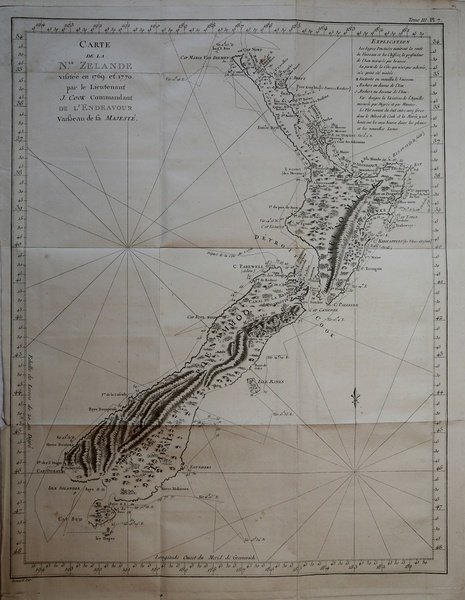
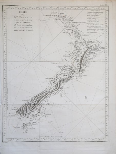
Edizione francese della mappa della Nuova Zelanda del capitano J. Cook, che riporta le rotte seguite intorno alle due grandi isole (Isola del Nord e Isola del Sud) dal 6 ottobre 1769 al primo aprile 1770.James Cook fu il primo a operare il rilevamento integrale delle coste.Esemplare tratto dalla prima edizione dell'opera "Relation des voyages entrepris par ordre de Sa Majeste? Britannique . . ." di John Hawkersworth, pubblicata a Parigi nel 1774.Incisione su rame, carta irregolare il solo margine sinistro, per il resto in perfetto stato di conservazione. French edition of Cook’s foundation map of New Zealand, showing the track of the Endeavour around both islands, from October 6, 1769, to April 1, 1770.From John Hawkesworth’s "Relation des voyages entrepris par ordre de Sa Majeste? Britannique . . ." (Paris, 1774). Copperplate, in very good condition.Endeavour came within sight of land on April 19, well north of the area charted by Tasman 125 years earlier. The New Holland (Australia) coast was exasperating, however, and Cook could not find a safe place to land until the afternoon of Saturday, April 28, when they entered Botany Bay (part of today’s Sydney Harbor), which Cook later named for the wide variety of plant life found there. The Aborigines that they saw there were unintelligible to Tupaia and kept away, avoiding contact. Through May and into June, Endeavour sailed north, arcing northwest, following the Great Barrier Reef coastline. On the evening of June 10, when most of the men were sleeping, the ship struck coral, stuck fast, and began leaking. Quick thinking and decisive action by Cook and his men—pumping furiously and jettisoning fifty tons of decayed stores, stone ballast, and cannons—kept the ship afloat and allowed a temporary underwater repair. A few days later, the damaged ship was safely beached on a barren shore (near today’s Cooktown, by the EndeavourRiver), and a fury of activity began more permanent work: the expedition had avoided a real disaster. (Henceforth, the British Admiralty would send Cook out with two ships for safety.) During this time, the men enjoyed more favorable interactions with the natives, but not without miscommunications and incidents of distrust. By August 13, the ship was ready to resume its journey.The labyrinth of treacherous islands and reefs was threaded slowly and carefully, with vigilance and some luck, as the expedition sailed northward through the Great Barrier Reef, westward around the northernmost point of New Holland, and into what Cook called Endeavour Strait. He stopped briefly at Possession Island (his name) where, now knowing he was in territory explored by the Dutch, he claimed the whole coastline he had just charted for King George III. It was a proud moment, essentially marking the end of Cook’s first Pacific voyage’s geographical discoveries. Cfr.
