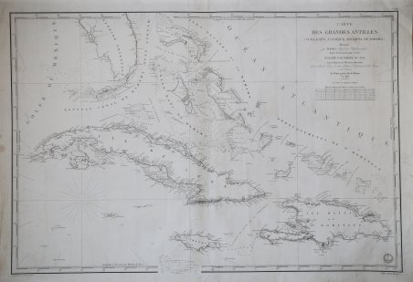
Carte Des Grandes Antilles (Cuba, Haiti, Jamaique, Archipel De Bahama)
Carte Des Grandes Antilles (Cuba, Haiti, Jamaique, Archipel De Bahama) | Stampe | Dépôt des cartes et plans de la Marine
Stampe
Dépôt des cartes et plans de la Marine
1843
Carte Des Grandes Antilles (Cuba, Haiti, Jamaique, Archipel De Bahama)
Carte Des Grandes Antilles (Cuba, Haiti, Jamaique, Archipel De Bahama) | Stampe | Dépôt des cartes et plans de la Marine
Stampe
Dépôt des cartes et plans de la Marine
1843
575,00 €
(Roma,
Italia)
Metodi di Pagamento
- PayPal
- Carta di Credito
- Bonifico Bancario
- Pubblica amministrazione
- Carta del Docente
Dettagli
- Anno di pubblicazione
- 1843
- Luogo di stampa
- Parigi
- Formato
- 890 X 600
- Incisori
- Dépôt des cartes et plans de la Marine
Descrizione
Decorativa carta nautica delle Antille, realizzata dall'idrografo M. Keller ed edita a Parigi. In ottime condizioni. Decorative chart focused on the Greater Antilles. Prepared by M. Keller, hydrographer and engineer. Highly detailed charts of Florida and the Caribbean, from the French Depot De La Marine. Excellent detail throughout. Based upon a map by Keller. Civil War vintage French charts of Florida and the Caribbean are very rare on the market.Relief shown by hachures. With a table allowing the convertion from metres to brasses (a French measure of depth of water corresponding to the fathom) and feet, under the title.Very good conditions. Cfr.
