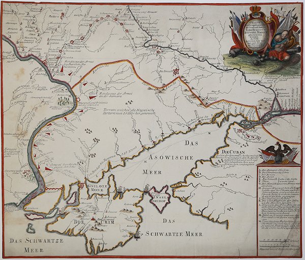
Charte der Kriegs Operationen am Donn und Dnieper. Ihro Russisch Key Serl: Maiesty: gloriousen Armeen A 1736. .
Charte der Kriegs Operationen am Donn und Dnieper. Ihro Russisch Key Serl: Maiesty: gloriousen Armeen A 1736. . | Stampe | Accademia delle Scienze


Charte der Kriegs Operationen am Donn und Dnieper. Ihro Russisch Key Serl: Maiesty: gloriousen Armeen A 1736. .
Charte der Kriegs Operationen am Donn und Dnieper. Ihro Russisch Key Serl: Maiesty: gloriousen Armeen A 1736. . | Stampe | Accademia delle Scienze
Metodi di Pagamento
- PayPal
- Carta di Credito
- Bonifico Bancario
- Pubblica amministrazione
- Carta del Docente
Dettagli
- Anno di pubblicazione
- 1736
- Luogo di stampa
- San Pietroburgo
- Formato
- 455 X 385
- Incisori
- Accademia delle Scienze
- Descrizione
- Atlas Ukrainae et Ponti Euxini (C15-18), 42.
Descrizione
Rarissima carta della parte meridionale dell’Ucraina, con la penisola della Crimea ed il Mar Nero. La carta è una delle 5 mappe pubblicate dalla Accademia delle Scienze di San Pietroburgo ad uso dell’esercito Russo durante la guerra contro i Turchi, iniziata nel 1735. La mappa è gravemente distorta rispetto alla realtà e fu rifiutata dagli Ufficiali dell’esercito. Incisione in rame, finemente colorata a mano, tracce di sporco all’angolo inferiore, per il resto in ottimo stato di conservazione. Very rare map of the southern part of Ukraine, with an explanatory key A-N in lower right. One of five maps published by Academy of Sciences in Saint Petersburg for use by Russian army during Russian-Turkish war started in 1735. Bagrow thinks they are based on some French maps. All these maps are huge step back comparing with Beauplan. When the maps have been send for review to the front line, one of the officers replied: "Maps are totally erroneous and have nothing to do with real topography and distances, and therefore any improvement is impossible". Unfortunately publishers in Western Europe have not seen this review, and the maps were widely copied in Germany and Netherlands for about next thirty years. Copperplate with fine hand colour, trimmed to the platemark, Elaborate cartouche on upper right corner, small repaired area at lower right corner, generally in very good conditions. Cfr. Atlas Ukrainae et Ponti Euxini (C15-18), 42.
