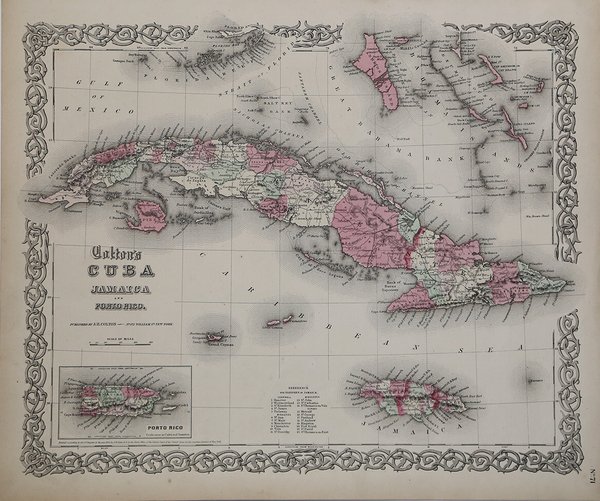
Cuba Jamaica and Porto Rico
Cuba Jamaica and Porto Rico | Stampe | COLTON Georg Woolworth


Cuba Jamaica and Porto Rico
Cuba Jamaica and Porto Rico | Stampe | COLTON Georg Woolworth
Metodi di Pagamento
- PayPal
- Carta di Credito
- Bonifico Bancario
- Pubblica amministrazione
- Carta del Docente
Dettagli
- Anno di pubblicazione
- 1866
- Luogo di stampa
- New York
- Formato
- 400 X 320
- Incisori
- COLTON Georg Woolworth
Descrizione
Carta geografica tratta dal celebre "Colton's General Atlas" edito a New York per la prima volta nel 1866. Acquaforte, lastra di zinco acciaiata, coloritura editoriale, in buono stato id conservazione.La mappa presenta molti dettagli, tra cjui città, fiumi, laghi e montagne. Map taken from Colton's General Atlas, Containing One Hundred And Eighty Steel Plate Maps And Plans, On One Hundred And Nineteen Imperial Folio Sheets, Drawn By G. Woolworth Colton. Letter-Press Descriptions, Geographical, Statistical, And Historical, By Richard Swainson Fisher. New York: G.W. & C.B. Colton, No. 172 William Street. London: Bacon & Co., 48 Paternoster Row. 1866. Entered … 1863, by J.H. Colton … New York. Good conditions.Shows outstanding detail throughout. Cuba and Jamaica are colored by counties and parishes, with towns, rivers, lakes, mountains and other details shown.Roads system is shown in Cuba. Cayman Islands is shown in nice detail, as are a portion of the Bahamas. Cfr.
