De Oude Wereldt tot beter verstandt der Oude Geschiedenissen.
De Oude Wereldt tot beter verstandt der Oude Geschiedenissen. | Stampe | Wetstein Gerard & Rudolf
De Oude Wereldt tot beter verstandt der Oude Geschiedenissen.
De Oude Wereldt tot beter verstandt der Oude Geschiedenissen. | Stampe | Wetstein Gerard & Rudolf
Metodi di Pagamento
- PayPal
- Carta di Credito
- Bonifico Bancario
- Pubblica amministrazione
- Carta del Docente
Dettagli
- Anno di pubblicazione
- 1728
- Luogo di stampa
- Amsterdam
- Formato
- 715 X 365
- Incisori
- Wetstein Gerard & Rudolf
Descrizione
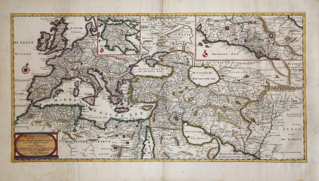
Un'insolita carta storica che ricopre il Mar Mediterraneo. In basso a sinistra il cartiglio del titolo con la spiegazione delle abbreviazioni utilizzate. In alto a destra un inserto con la mappa di parte dell'Italia. In alto, a sinistra del centro, un inserto con la mappa del Peloponneso. La carta presenta una divisione in gradi lungo i bordi. Il foglio è splendidamente inciso e ricco di antichi toponimi. La carta è tratta dall'Algemene kerkelyke en wereldlyke geschiedenissen des bekenden aard-kloots di Sugars Geerlof e Isaac Verburg, pubblicato in 5 volumi. Amsterdam: Gerard e Rudolf Wetstein, 1721-1728. Rame con bei colori a mano successivi, ottimo stato di conservazione. Stampato su due fogli uniti. An unusual map of the Old World that covers the Mediterranean Sea. Bottom left of the title cartouche with an explanation of abbreviations used at the bottom. Top right an inset with a map of part of Italy. Above, left of center, an inset with a map of the Peloponnese. The map has a degree division along the edges. The sheet is beautifully engraved and filled with ancient place names. Printed on two joined sheets. Marked top right: 1. part. page 1. The map is taken from the Algemene kerkelyke en wereldlyke geschiedenissen des bekenden aard-kloots by Sugars Geerlof and Isaac Verburg, published in 5 volumes. Amsterdam: Gerard and Rudolf Wetstein, 1721-1728. Copperplate with fine later hand colour, very good condition. Cfr.
