Description Generale de Toute la France
Description Generale de Toute la France | Stampe | BELLEFOREST Francois de

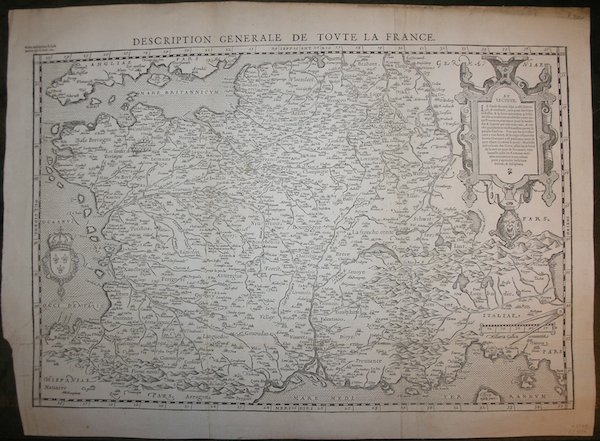
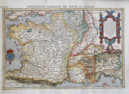
Description Generale de Toute la France
Description Generale de Toute la France | Stampe | BELLEFOREST Francois de
Metodi di Pagamento
- PayPal
- Carta di Credito
- Bonifico Bancario
- Pubblica amministrazione
- Carta del Docente
Dettagli
- Anno di pubblicazione
- 1575
- Luogo di stampa
- Parigi
- Formato
- 510 X 340
- Incisori
- BELLEFOREST Francois de
- Lingue
- Italiano
Descrizione
Prima derivazione a stampa della carta della Galliae Regni Potentiss: Nova Descriptio Joanne Ioliveto Auctore… di Abraham Ortelius, pubblicata nel Theatrum Orbis Terrarum del 1570 e, a sua volta, derivazione della mappa in 4 fogli di Jean Olivet (1560). Il foglio è tratto dalla celebre La Cosmographie Universelle de tout le Monde (Parigi, 1575) di Francois de Belleforest, traduzione francese della Cosmographia di Sebastian Muenster. A differenza del Muenster, questa opera è pubblicata in una sola edizione, e risulta pertanto molto rara. Le tavole xilografiche incluse nell’opera sono derivazioni da Abraham Ortelius, Braun & Hogenberg oltre che da Muenster. Alcuni legni sono invece ripresi utilizzando le matrici pubblicate per la prima volta nel 1552 nella Cosmografia di Lione da Guèroult & Balthazar Arnoullet (1517-1556), nel Premier livre des figure set pourtraitz des villes plus illustre set renommées d’Europe, contenente 9 immagini urbane, perlopiù copiate dalla Cosmographia di Sebastian Muenster. L'opera fu pubblicata in due volumi. Solo 49 delle 163 incisioni che compaiono nei due volumi sono tratti dalla Cosmographia del Munster. Gli editori Chesneau e Sonnius fecero uso anche di materiale da poco apparso sul mercato librario. Xilografia, finemente colorata a mano, in ottimo stato di conservazione. Bibliografia M. Pastoureau, ' LES ATLAS FRANÇAIS XVIe-XVIIe siècles. Répertoire bibliographique et étude. - Belleforest I-1 [2]. First printed derivation of the map of Galliae Regni Potentiss: Nova Descriptio Joanne Ioliveto Auctore. by Abraham Ortelius, published in Theatrum Orbis Terrarum in 1570 and, in turn, derivation of the 4-sheet map by Jean Olivet (1560). The primary difference is that while the Ortelius map is a copperplate engraving, while Belleforest continues the tradition of woodcut maps, copperplate maps not having yet gained currency in France. Ortelius's map was the first widely disseminated modernized map of Europe in the latter part of the 16th century and became the standard map of the continent until well into the 17th Century. The sheet is taken from the famous La Cosmographie Universelle de tout le Monde (Paris, 1575) by Francois de Belleforest, a French translation of Sebastian Muenster's Cosmographia. Unlike the Muenster, this work is published in only one edition, and is therefore very rare. The woodcut plates included in the work are derivations from Abraham Ortelius, Braun & Hogenberg as well as Muenster. Some woodcuts, however, are taken using the plates first published in 1552 in the Cosmographia de Lyon by Guèroult & Balthazar Arnoullet (1517-1556), in the Premier livre des figures set pourtraitz des villes plus illustre set renommées d'Europe, containing 9 urban images, mostly copied from Sebastian Muenster's Cosmographia. The work was published in two volumes. Only 49 of the 163 woodcuts that appear in the two volumes are taken from Munster's Cosmographia. The publishers Chesneau and Sonnius also made use of material that had recently appeared on the book market. Woodcut with fine later hand colour, very good condition. Bibliografia M. Pastoureau, LES ATLAS FRANÇAIS XVIe-XVIIe siècles. Répertoire bibliographique et étude. - Belleforest I-1 [2]. Cfr.
