Die Oestliche und Westliche Halbkugel der Erde
Die Oestliche und Westliche Halbkugel der Erde | Stampe | MEYER Carl Joseph
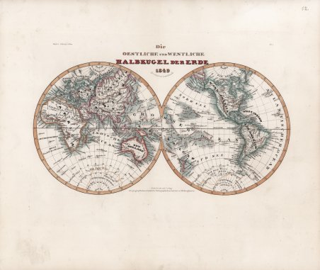
Die Oestliche und Westliche Halbkugel der Erde
Die Oestliche und Westliche Halbkugel der Erde | Stampe | MEYER Carl Joseph
Metodi di Pagamento
- PayPal
- Carta di Credito
- Bonifico Bancario
- Pubblica amministrazione
- Carta del Docente
Dettagli
- Anno di pubblicazione
- 1849
- Luogo di stampa
- Hildburghausen
- Formato
- 250 X 190
- Incisori
- MEYER Carl Joseph
Descrizione
Bella mappa del mondo del 1849, raffigurato in due emisferi da Joseph Meyer. Sia l'emisfero occidentale che quello orientale sono disegnati e offrono un'affascinante istantanea del mondo durante un periodo di rapida globalizzazione e scoperta. L'Africa e l'Australia sono in gran parte non disegnate all'interno, ma le coste sono rappresentate con precisione. Le coste dell'Antartide sono disegnate in modo sommario, sulla base delle prime spedizioni. La mappa è codificata a colori in base ai continenti. ' Dal "Neueste Zeitungs-Atlas für Alte & Neue Erdkunde" di Carl Joseph Meyer (1796 – 1856). ' L’atlante venne pubblicato nel 1852 a Hildburghausen, Amsterdam e New York. Comprendeva 123 carte di geografia antica, moderna e di geografia fisica. Le mappe sono considerate tra le più dettagliate del XIX secolo, con informazioni minuziose che mostrano i confini politici e amministrativi, le città, i paesi, i canali, i forti, le strade, le ferrovie, i fiumi e le montagne. Incisione su acciaio, coloritura coeva dei contorni, leggere ossidazioni, per il resto in ottimo stato di conservazione. This is a fine 1849 map of the world depicted in hemispheres by Joseph Meyer. Both the Western and Eastern Hemispheres are drawn and offer a fascinating snapshot of the world during a period of rapid globalization and discovery. Africa and Australia are largely unmapped in the interiors with coastlines accurately rendered. The coast of Antarctica is drawn in sketchily, based upon early expeditions. The map is color coded according to continents. Various important cities, rivers, islands, mountain ranges, and several other topographical details are noted with relief shown in hachure. Taken form ' Neueste Zeitungs-Atlas für Alte & Neue Erdkunde ' With a engraved title page, index, and 123 steel engraving outline hand colored maps dated between 1849-1852. These atlas maps were produced in Hildburghausen, Amsterdam, and New York, and are considered some of the most detailed maps produced in the 19th Century. ' Atlas includes 123 maps of old geography, maps of modern geography, and maps of physical geography. The maps are of the highest Meyer quality, with detail information, showing political and administrative boundaries, cities, towns, canals, forts, roads, railroads, rivers and mountains. Steel-engraving, contemporary hand-coloring, light foxing, otherwise in very good condition. Cfr.
