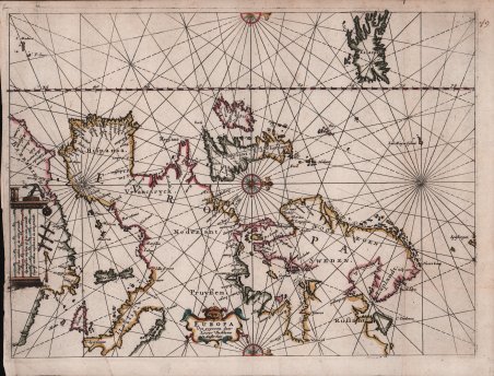
Europa Uyt gegeven door Lowys Vlasbloem 't Amsterdam
Europa Uyt gegeven door Lowys Vlasbloem 't Amsterdam | Stampe | Vlasbloem Louis
Europa Uyt gegeven door Lowys Vlasbloem 't Amsterdam
Europa Uyt gegeven door Lowys Vlasbloem 't Amsterdam | Stampe | Vlasbloem Louis
Metodi di Pagamento
- PayPal
- Carta di Credito
- Bonifico Bancario
- Pubblica amministrazione
- Carta del Docente
Dettagli
- Anno di pubblicazione
- 1656
- Luogo di stampa
- Amsterdam
- Formato
- 254 X 178
- Incisori
- Vlasbloem Louis
- Descrizione
- S. Bifolco, "Mare Nostrum, Cartografia nautica a stampa del Mar Mediterraneo" (2020), p. 104, tav. 37.
Descrizione
Europa Uyt gegeven door Lowys Vlasbloem 't AmsterdamOpera tratta, con molta probabilità, dal Nieuwe Lees-Kaert dati s, de gheheele nieuwe Nord-See beschrijvende de custen der Suyderzee, Vlie-stroom, het Watt, ende de Iutsche custen, tot aen Schaghen toe. t’ Amsterlredam. Gedruckt by Louis Vlasbloem Boeckvercoper, 1656.Acquaforte e bulino, 254x178 mm, firmata in lastra nel cartiglio in basso al centro.Rarissima carta nautica di Europa e Mediterraneo di Louis Vlasbloem; esemplare con coloritura coeva, in perfetto stato di conservazione.Le uniche notizie biografiche di Louis Vlasbloem - libraio, stampatore e mercante di carte – si ricavano esclusivamente dalle sue rarissime opere a stampa. Iniziò l’attività probabilmente nella città di Harlingen, in Frisia, stando all’indirizzo riportato sul suo libretto più antico, il Nieu Wadt-Boexk, “Tot Harlingen. Door Louis Hessels-Vlasbloem, Boeckvercoper by de Haven-poor t in de Zee-Colom, Anno 1646”; l’insegna tipografica - Zee-Colom – è la medesima utilizzata da Jacob Aertsz. Colom ad Amsterdam. Si ricava poi che si trasferì a Dokkum dove stampò un’edizione del Viaggio di Schouten e Lemaire (1649), per stabilirsi ad Amsterdam nel 1650, secondo quanto risulta dall’indirizzo riportato nelle sue guide nautiche. Vlasbloem pubblicò diverse guide nautiche per i mercati olandese e inglese, dal 1646 al 1660 circa. Le sue opere erano apparentemente utilizzate dai marinai comuni che lavoravano nei mari tra l’Olanda e le Isole Britanniche, poiché tutte sono oggi estremamente rare, molto usurate e spesso parzialmente incomplete. Dal punto di vista cartografico Vlasbloem si basava sui maggiori atlanti nautici del periodo, e le sue poche carte nautiche - in tutto 11 - risultano essere delle accurate riduzioni di opere già stampate. Ad esempio, il Christianus Orbis, sive Europa Marina Accommodata jam ad Usum Atlantis (1658), contiene nove carte piegate, raccolte dalle guide nautiche del Vlasbloem. Questo piccolo atlante nautico imita i più grandi portolani stampati da Jacob Aertsz. Colom. Poiché la maggior parte delle sue opere sono conosciute solo in uno o due esemplari, non è possibile conoscere l’opera di provenienza di ciascuna delle mappe.È possibile che la presente mappa sia stata inclusa nel Nieuwe lees-kaert di Vlasbloem (1656), una guida nautica composta da 5 diverse parti - divise da altrettanti frontespizi - e contenente le 11 carte prodotte dal tipografo. Della prima edizione, l’unico esemplare completo è quello conservato alla University Library di Leida, mentre dell’opera è nota una variante successiva presso il Maritime Museum di Rotterdam. Altri esemplari, non completi, sono quelli della Library of Congress e della British Library.Bibliografia: C. Koeman, Atlantes Neerlandici: Bibliography of Terrestrial, Maritime and Celestial Atlases and Pilot Books Published in the Netherlands up to 1880 Vol. IV, Amsterdam 1970, pp. 460-462, Vl 4 (1); cfr. R. Shirley, Maps in the Atlases of the British Library, Londra, 2004, p. 1315. Etching and engraving, 254x178mm, signed in the lower centre cartouche. Magnificient example, original colors, in perfect condition.Extremely rare sea chart of the foma; approach to Amsterdam by sea from the North, beginning with the southern part of Vrieslant and West Vrieslandt, passing the towns of Taveren, Enckusen and Hoorn and finally to Amsterdam in the South. showing the final part of the crossing from England and the British Isles to Amsterdam from the North Sea, published by Louis Vlasbloem in Amsterdam.Vlasbloem's published several books of Sea Charts for the Dutch and English Markets, from about 1646 to 1660. His works were available to and apparently heavily used by common mariners working the seas between Holland and the Bitish Isles, asall of his works are extremely rare and most survive in various states of damage and disrepair. For example, there are only 3 or 4 known examples of his North Zea . . . , none of which is complete. It is possible that the present map was included in Vlasbloem's Nieuwe lees-kaert, dat is de westersche schipvaert, ofte loots-mans wegh-wijser, inhoudende; alle de zee-custen van de Zuyder-Zee, Hollandt, Zeelandt, . However, because most of his works are known in only 1 or 2 examples, it is not possible to know the appearnces of each of the maps. The only complete copy of the first edition is the one kept at the University Library of Leiden, while a later variant is known at the Rotterdam Maritime Museum. Other examples, not complete, are those of the Library of Congress and the British Library.Bibliografia: C. Koeman, Atlantes Neerlandici: Bibliography of Terrestrial, Maritime and Celestial Atlases and Pilot Books Published in the Netherlands up to 1880 Vol. IV, Amsterdam 1970, pp. 460-462, Vl 4 (1); cfr. R. Shirley, Maps in the Atlases of the British Library, Londra, 2004, p. 1315. Cfr. S. Bifolco, "Mare Nostrum, Cartografia nautica a stampa del Mar Mediterraneo" (2020), p. 104, tav. 37.
