Francia Franck reich
Francia Franck reich | Stampe | BOTERO Giovanni

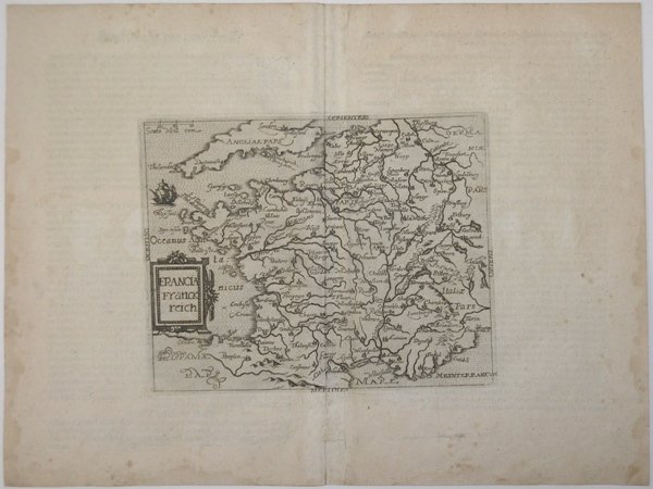
Francia Franck reich
Francia Franck reich | Stampe | BOTERO Giovanni
Metodi di Pagamento
- PayPal
- Carta di Credito
- Bonifico Bancario
- Pubblica amministrazione
- Carta del Docente
Dettagli
- Anno di pubblicazione
- 1597
- Luogo di stampa
- Colonia
- Formato
- 190 X 153
- Incisori
- BOTERO Giovanni
- Lingue
- Italiano
Descrizione
Carta geografica tratta dall’edizione tedesca delle opere di Giovanni Botero, denominata Theatrum oder Shawspiegel, edita nel 1596 da Lambert Andreas, che nello stesso anno pubblica anche l’edizione con testo latino. L'opera fa parte degli atlanti editi dalla cosiddetta Scuola Cartografica di Colonia, durata per circa mezzo secolo (1570-1620 ca.), e formata principalmente da rifugiati fiamminghi e olandesi tra i quali spiccano lo stesso Matthaeus Quad e Frans Hogenberg, che ne fu il fondatore. Le mappe sono attribuite alcune a Jan Matal ed altre a Michael von Eitzing. Dal punto di vista cartografico le mappe sono una derivazione e basate sulle carte pubblicate ad Anversa da Abraham Ortelius, per la prima volta nel 1570; le incisioni delle mappe sono invece attribuite a Frans Hogenberg. La grandissima rarità dell'opera, insieme alla scarsità di informazioni sulle opere "carbonare" edite a Colonia, contribuisce al fascino di questa importante mappa, caposaldo di ogni collezione cartografica. Ogni raccolta risulta diversa dall’altra, come ampiamente documentato nel saggio di Peter H. Meurer, Atlantes Colonienses, Die Kolner Schule der Atlaskartographie 1570-1610. Il nostro esemplare corrisponde alla raccolta descritta come BOT 2. Giovanni Botero (1544 – Torino 1617) è stato un presbitero, scrittore e filosofo italiano, autore delle Relazioni universali, un trattato di geografia politica pubblicato per la prima volta a Roma nel 1591 senza illustrazioni cartografiche. L’opera divenne subito molto importante ed oggetto di studio in tutta Europa, dando inizio praticamente allo studio della demografia. Jan Matal o Metellus, francese di nascita ed attivo a Louvaine ed a Colonia, dove si rifugia proprio per sfuggire alle persecuzioni dei regnanti cattolici e dove muore nel 1597. Fu tra i maggiori cartografi del tempo e, insieme al Quad e al Hogenberg stesso, il principale esponente della scuola coloniese. Alcune delle mappe del Matal sono poi successivamente incluse nelle successive pubblicazioni postume, e recano il testo al verso. Lambert Andreas (attivo tra il 1590 ed il 1598) fu principalmente editore, tuttavia, alcune delle mappe nelle sue pubblicazioni sono a lui stesso attribuite, sebbene in maniera dubitativa. Dal punto di vista cartografico le mappe sono una derivazione delle carte pubblicate ad Anversa da Abraham Ortelius, per la prima volta nel 1570. L’intaglio delle mappe viene attribuito a Frans Hogenberg. Incisione in rame, impressa su carta vergata coeva, consueta piega centrale, piccole ossidazioni, per il resto in ottimo stato di conservazione. Bibliografia Meurer, Atlantes Colonienses Die Kolner Schule der Atlas Kartographie 1570-1610, pp. 74/78, BOT 2; cfr. Ginsberg, Printed Maps of Scandinavia and the Arctic, pp.150/153, 35 & 36; cfr. Suarez, Early Mapping of Southeast Asia, pp. 186/7, 104; cfr. Burden, The Mapping of North America, p. 115, 90; cfr. Shirley, Early Printed Maps of the British Isles, p. 83, 189; cfr. Borri, L’Italia nelle antiche Carte, p. 95, 106; cfr. Walter, Japan a Cartographic Vision, 20; cfr. Tibbets, Arabia in Early Maps, p. 57, 50. Map taken from the German edition of Giovanni Botero's works, called Theatrum oder Shawspiegel, edited in 1596 by Lambert Andreas, who also published the Latin text edition in the same year. The work is part of the atlases edited by the so-called Cartographic School of Cologne, which lasted for about half a century (c. 1570-1620), and consisted mainly of Flemish and Dutch refugees, among them Matthaeus Quad himself and Frans Hogenberg, who was its founder. The maps are attributed some to Jan Matal and others to Michael von Eitzing. Cartographically, the maps are a derivation of and based on maps first published in Antwerp by Abraham Ortelius in 1570; the engravings of the maps, however, are attributed to Frans Hogenberg. The great rarity of the works contributes to the appeal of this important map, a cornerstone of every cartographic collection. Each collection turns out to be different from the other, as extensively documented in Peter H. Meurer's essay, Atlantes Colonienses, Die Kolner Schule der Atlaskartographie 1570-1610. Our example corresponds to the Atlas described as BOT 2. Giovanni Botero (1544 - Turin 1617) was an Italian presbyter, writer and philosopher, author of Relazioni universali, a treatise on political geography first published in Rome in 1591 without cartographic illustrations. The work immediately became very important and an object of study throughout Europe, virtually beginning the study of demography. Jan Matal or Metellus, French by birth and active in Louvaine and Cologne, where he took refuge precisely to escape persecution by the Catholic rulers and where he died in 1597. He was among the leading cartographers of the time and, along with Quad and Hogenberg himself, the leading exponent of the Cologne school. Some of Matal's maps are later included in later posthumous publications and bear the text on the verso. Lambert Andreas (active between 1590 and 1598) was primarily an editor, however, some of the maps in his publications are attributed to him, albeit dubiously. Cartographically, the maps are a derivation of maps first published in Antwerp by Abraham Ortelius in 1570. Copperplate engraving, impressed on contemporary laid virgin paper, usual central crease, minor oxidation, otherwise in very good condition. Bibliografia Meurer, Atlantes Colonienses Die Kolner Schule der Atlas Kartographie 1570-1610, pp. 74/78, BOT 2; cfr. Ginsberg, Printed Maps of Scandinavia and the Arctic, pp.150/153, 35 & 36; cfr. Suarez, Early Mapping of Southeast Asia, pp. 186/7, 104; cfr. Burden, The Mapping of North America, p. 115, 90; cfr. Shirley, Early Printed Maps of the British Isles, p. 83, 189; cfr. Borri, L’Italia nelle antiche Carte, p. 95, 106; cfr. Walter, Japan a Cartographic Vision, 20; cfr. Tibbets, Arabia in Early Maps, p. 57, 50. Cfr.
