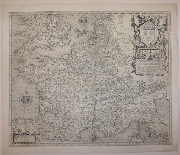
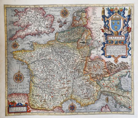
Gallia. Gallia Geographica Galliae descriptio, de integro plurimis in locis emendata ac Regionum limitibus distincta, auctor
Gallia. Gallia Geographica Galliae descriptio, de integro plurimis in locis emendata ac Regionum limitibus distincta, auctor | Stampe | VRIENTS Johannes Baptiste

Gallia. Gallia Geographica Galliae descriptio, de integro plurimis in locis emendata ac Regionum limitibus distincta, auctor
Gallia. Gallia Geographica Galliae descriptio, de integro plurimis in locis emendata ac Regionum limitibus distincta, auctor | Stampe | VRIENTS Johannes Baptiste
Metodi di Pagamento
- PayPal
- Carta di Credito
- Bonifico Bancario
- Pubblica amministrazione
- Carta del Docente
Dettagli
- Anno di pubblicazione
- 1606
- Luogo di stampa
- Anversa
- Formato
- 480 X 400
- Incisori
- VRIENTS Johannes Baptiste
- Lingue
- Italiano
Descrizione
Titolo nel cartiglio in alto a destra: GALLIA | Geographica Galliæ descriptio, de integro | plurimis in locis emendata ac Regionum | limitibus distincta; auctore Petro Plantio. | "Quicquid terrarum Rheno, Alpibus, mari Mediterraneo, Pyre: | næis montibus, oceano Aquitanico Brittanico et Germanico, | clauditur; communi nomine Latinis Gallia appellatur: quibus limi: | tibus potentissimum Francorum regnum, Sabaudiæ, Burgundiæ | comitatus, Helvetia, Alsatia, Lotharingia, inferior Germania, | et quædam aliæ regionis hodie continentur. | Ioannes Bap: | tista Vrints | excudit" Una delle più decorative e rare mappe di Johannes Baptiste Vrients contenute nelle edizioni postume del ' Theatrum Orbis Terrarum di Ortelius. La mappa è una fedele ed ingannevole copia della carta di Petrus Plancius (1552-1622), incisa dai fratelli van Deutecum e pubblicata dallo stesso Vrients nel 1592. Esemplare nel secondo stato, con l’imprint Theodor. Gallæus | excudebat | Antverpiæ, che compare nell’edizione del 1612. Il ' Theatrum Orbis Terrarum ' è considerato il primo vero “atlante” moderno. L’opera fu pubblicata in 7 lingue e 36 edizioni, per il quale – nel 1570 - Ortelius ottenne il ' privilegio, ovvero una sorta di diritto d'autore che impediva ad altri cartografi di pubblicare i propri lavori. Il ' Theatrum ' rappresentava il lavoro più avanzato del lavoro della descrizione cartografica. L’Ortelius vi raccolse il sapere geografico e cartografico del suo tempo, proponendo in 147 spettacolari tavole incise l’immagine più fedele del mondo allora conosciuto e, in alcune straordinarie “carte storiche”, regioni e itinerari tratti dalla letteratura, dalla mitologia, dalla tradizione. Ortelius fu anche il primo a citare le fonti, menzionando i nomi dei cartografi nel “catalogus auctorum”. Dal 1598 al 1612 le edizioni postume del ' Theatrum ' furono realizzate dal suo collaboratore Johannes Baptiste Vrients. Acquaforte e bulino, impressa su carta coeva e rifilata alla linea marginale, con margini coevi aggiunti, lieve mancanza di parte incisa sotto al cartiglio, per il resto in buone condizioni. Rara. Bibliografia Cfr. L. Bagrow, A. Ortelli Catalogus Cartographorum; cfr. C. Koeman, Atlantes Neerlandici; Peter H. Meurer, Fontes Cartographici Orteliani 150; M. Van den Broecke, Ortelius Atlas Maps, n. 36 II/II; Van der Krogt, Koeman’s Atantes Neerlandici: 4000:31C. Title in the cartouche: GALLIA | Geographica Galliæ descriptio, de integro | plurimis in locis emendata ac Regionum | limitibus distincta; auctore Petro Plantio. | "Quicquid terrarum Rheno, Alpibus, mari Mediterraneo, Pyre: | næis montibus, oceano Aquitanico Brittanico et Germanico, | clauditur; communi nomine Latinis Gallia appellatur: quibus limi: | tibus potentissimum Francorum regnum, Sabaudiæ, Burgundiæ | comitatus, Helvetia, Alsatia, Lotharingia, inferior Germania, | et quædam aliæ regionis hodie continentur. | Ioannes Bap: | tista Vrints | excudit" [A geographical depiction of France, entirely improved in many places and distinguished by the borders of its regions; by Petrus Plancius, the lands of which are defined by the Rhine, the Alps, the Pyrenee mountains, and the Mediterranean, British and German oceans, called with its general Latin name Gallia; The present borders of this mighty kingdom of the French are Sabaudia, Burgundy, Helvetia, Alsatia, Lotharingia, Lower Germany and some other regions. Made by Ioannes Baptista Vrients]. One of the rare decorative Vrients maps which were added to the Ortelius Atlas from 1606 on. The map is a faithful and misleading copy of the map of Petrus Plancius (1552-1622), engraved by the van Deutecum brothers and published by Vrients himself in 1592. Example in the second state, imprinted Theodor. Gallæus | excudebat | Antverpiæ, which appears in the 1612 edition. Map taken from the ' Theatrum Orbis Terrarum, which is considered the first true modern "Atlas". The work was published in 7 languages and 36 editions, for which - in 1570 - Ortelius obtained the privilege, a kind of copyright that prevented other cartographers from publishing his works. The ' Theatrum ' represented the most advanced work of cartographic description. Ortelius collected in it the geographical and cartographic knowledge of his time, proposing in 147 spectacular engraved plates the most faithful image of the world then known and, in some extraordinary "historical maps", regions and routes taken from literature, mythology, tradition. Ortelius was also the first to cite sources, mentioning the names of cartographers in the "catalogus auctorum". From 1598 to 1612 the posthumous editions of the ' Theatrum ' were made by his collaborator Johannes Baptiste Vrients. Etching and engraving, impressed on contemporary paper and trimmed at marginal line, with coeval margins added, slight lack of engraved portion below cartouche, otherwise in good condition. Rare. Bibliografia Cfr. L. Bagrow, A. Ortelli Catalogus Cartographorum; cfr. C. Koeman, Atlantes Neerlandici; Peter H. Meurer, Fontes Cartographici Orteliani 150; M. Van den Broecke, Ortelius Atlas Maps, n. 36 II/II; Van der Krogt, Koeman’s Atantes Neerlandici: 4000:31C. Cfr.
