Dettagli
Anno di pubblicazione
1786
Incisori
BRION de la Tour Louis
Descrizione
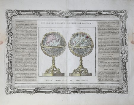
Una suggestiva coppia di sfere armillari incise che proiettano modelli del sistema solare, circondate da una cornice architettonica decorativa, impreziosita da putti e simboli cartografici. Illustrazione decorativa settecentesca di due globi in piedi, terrestre e celeste, con un ornato bordo barocco stampato su una lastra separata, pubblicata da Louis Charles Desnos per l'"Atlas General, Civil et Ecclesiastique, Methodique et Elementaire pour l'etude de la Geographie et de l'Histoire" di Louis Brion de la Tour. La disposizione multipla delle lastre permetteva a Desnos di stampare diverse edizioni dei suoi atlanti a partire dalle stesse lastre. Alcune edizioni presentavano pannelli di testo incollati su entrambi i lati della mappa, mentre altre erano stampate solo con un bordo decorativo. La carta è ornata con colori originali a mano. Nel XVIII secolo i cartografi amavano includere incisioni di sfere e globi nei loro atlanti generali, poiché l'astronomia e la conoscenza dei pianeti erano diventate di moda e una parte importante delle nuove scoperte del "Secolo dei Lumi". Questa bella incisione mostra a sinistra un globo terrestre centrato sull'emisfero orientale, con l'Oceano Indiano e il Sud-Est asiatico. A destra, un globo celeste con le costellazioni dell'Orsa Maggiore, Perseo, Gemelli, Scorpione, Toro, Vergine e altre. I globi poggiano su basi ornate in stile rococò e l'incisione è circondata da un bel bordo in stile cornice. Louis Brion de la Tour (1743 ca. - 1803) fu un geografo e cartografo francese. Nonostante la sua prolifica produzione e i suoi legami con la famiglia reale, i dettagli della sua vita rimangono relativamente oscuri. Gran parte del suo lavoro fu pubblicato da Denon e suo figlio, anch'egli Louis, probabilmente lavorò al fianco del padre. Louis Charles Desnos (1750-1790 circa) è stato un editore, libraio e cartografo francese. A striking pair of engraved armillary spheres projecting models of the Solar System, surrounded by a decorative architectural frame, embellished with cherubs and cartographic symbols. Attractive wash colors and illustrations of the signs of the zodiac and other features. From a deluxe edition of Desnos' work. A decorative eighteenth century illustration of two standing globes, terrestrial and celestial, with an ornate baroque border printed on a separate plate, published by Desnos for Brion's 'Atlas General, Civil et Ecclesiastique, Methodique et Elementaire pour l'etude de la Geographie et de l'Histoire'. The multiple plate arrangement allowed Desnos to print different editions of his atlases from the same map plates. Some editions featured paste-down text panels on either side of the map, while others were issued with just a border. The map is ornamented in original hand colour. In the 18th century cartographers liked to include engravings of spheres and globes in their general atlases, as astronomy and the knowledge of the planets had become fashionable and a major part of the new-found discoveries in the "Age of Enlightenment." This fine engraving shows at left a terrestrial globe centered on the eastern hemisphere, featuring the Indian Ocean and Southeast Asia. At right is a celestial globe featuring the constellations of Ursa Major, Perseus, Gemini, Scorpio, Taurus, Virgo and others. The globes are on ornate rococo-style bases, and the engraving is surrounded by a lovely picture-frame style border. Louis Brion de la Tour (c.1743-1803) was a French geographer and mapmaker. Despite his prolific output and Royal connections, details of his life remain relatively obscure. Much of his work was published by Denon, and his son, also Louis, likely worked alongside his father. Louis Charles Desnos (c.1750-1790) was a French publisher, bookseller, and globemaker. Cfr.

 Scopri come utilizzare
 Scopri come utilizzare