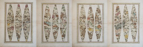
GLOBO CELESTE Calcolato per il corrente anno sulle Osservazioni de’ Sigg. Flamsteed, e de la Caille. ROMA presso la Calc.a
GLOBO CELESTE Calcolato per il corrente anno sulle Osservazioni de’ Sigg. Flamsteed, e de la Caille. ROMA presso la Calc.a | Stampe | CASSINI Giovanni Maria

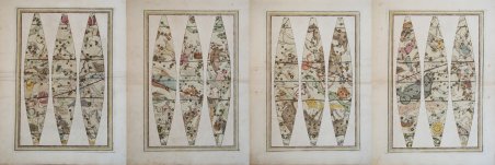
GLOBO CELESTE Calcolato per il corrente anno sulle Osservazioni de’ Sigg. Flamsteed, e de la Caille. ROMA presso la Calc.a
GLOBO CELESTE Calcolato per il corrente anno sulle Osservazioni de’ Sigg. Flamsteed, e de la Caille. ROMA presso la Calc.a | Stampe | CASSINI Giovanni Maria
Metodi di Pagamento
- PayPal
- Carta di Credito
- Bonifico Bancario
- Pubblica amministrazione
- Carta del Docente
Dettagli
- Anno di pubblicazione
- 1792
- Luogo di stampa
- Roma
- Formato
- 437 X 537
- Incisori
- CASSINI Giovanni Maria
- Soggetto
- Carte Celesti
- Lingue
- Italiano
Descrizione
- EDIZIONE ORIGINALE, COLORITURA COEVA - Sei fogli destinati alla costruzione del globo celeste, due dei quali firmati da Giovanni Maria Cassini, furono pubblicati nel 1792 in Roma dalla Calcografia Camerale. Il globo celeste è basato sulle osservazioni astronomiche di Flamsteed e Lacaille, e rappresenta tutte le costellazioni allora conosciute con le stelle di grandezza variabile secondo la loro magnitudo. Le tavole riproducono i dodici spicchi di 30 gradi di A. R. d’ampiezza che, una volta ritagliati e incollati su di una sfera di legno e cartapesta del diametro di 35 cm, compongono l’intero globo celeste. Nel cartiglio posto al centro di uno degli spicchi, tra Boote e il Monte Menalo, si legge “GLOBO CELESTE Calcolato per il corrente anno sulle Osservazioni de’ Sigg. Flamsteed, e de la Caille. ROMA presso la Calc.a Cam.le 1792” . Quattro delle cinque tavole sono destinate a rappresentare le costellazioni, queste sono le stesse che troviamo nei due planisferi, nominate in lingua italiana dell’epoca , disegnate però di spalle in proiezione convessa , pronte per essere incollate su di una sfera di circa trentacinque centimetri di diametro. Le costellazioni non tolemaiche sono in numero notevole: Antinoo, la Chioma di Berenice, la Giraffa, il Liocorno, La Mosca, il Cuor di Carlo II, il Monte Menalo, la Renna, il Cerbero, l’Oca, la Volpe, i Levrieri, la Lince, il Leone minore, il Triangolo minore, la Lucerta, la Colomba, la Croce, con il termine la Nuvola le due nubi di Magellano, il Liocorno, il Sestante, lo Scudo di Sobieski, le dodici costellazioni di Bayer-Keyser-Houtman, le quattordici (quindici se gli si accredita la Musca) di Lacaille e il Solitarius di Le Monnier denominato in italiano il Passero Solitario. Il reticolo di riferimento è ridotto al minimo presentando soltanto i Circoli Polari, i Circoli dei Tropici, l’Eclittica, l’Equatore. Manca il reticolo per la lettura della Declinazione e dell’Ascensione Retta; l’Equatore e l’Eclittica riportano una scala graduata in tacche di un grado numerate progressivamente di dieci in dieci, la numerazione dell’Eclittica ricomincia da capo ogni 30 gradi per rispettare i confini delle costellazioni zodiacali. (cfr. F. Stoppa, ' Atlas Colestis) Giovanni Maria Cassini (1745 – 1824) fu un costruttore di globi, geografo, incisore e cartografo italiano. La sua opera principale fu il ' Nuovo Atlante Geografico Universale ' del 1792-1801. Nel 1790 la Calcografia Camerale di Roma pubblicò I suoi dodici fusi per globo terrestre, aggiornato secondo le ultime rilevazioni effettuate durante I tre viaggi attorno al mondo del Capitano inglese James Cook. Bellissimo esemplare della rara prima edizione, impresso su carta vergata coeva della fine del ‘700 e finemente colorato a mano in epoca, piccole ossidazioni, per il resto in eccellente stato di conservazione. Dei globi del Cassini esistono tirature sempre della Calcografia Camerale su carta meccanica ottocentesca (di colore bianco, senza vergelle, databili tra il 1820 e il 1870) e tirature con il timbro a secco della Calcografia Regia (post 1870). Bibliografia M. Fiorini (1899), Sfere terrestri e celesti, pp. 442/443; Schmidt R., Sfere del cielo sfere della terra, globi celesti e terrestri dal XVI al XX secolo (catalogo della mostra), p. 49, scheda VII.69; Dekker, p. 66; Dahl & Gauvin, Sphaerae Mundi early globes at the Stewart Museum, p.131-134. - FIRST EDITION, CONTEMPORARY OUTLINE COLOUR -Giovanni Maria Cassini (1745 – 1824) was an Italian globe maker, geographer, engraver and cartographer. His main cartographic work was the Nuovo Atlante Geografico Universale of 1792-1801. In 1790, the Calcografia Camerale of Rome published his twelve terrestrial globe gores that updated the world cartography after the three voyages of Captain James Cook around the globe.The twelve celestial globe gores were published in 1792. The celestial globe is based on the astronomical observations of Flamsteed and Lacaille, and represents all the constellations then known with stars of variable magnitude according to their magnitude. The plates reproduce the twelve segments of 30 degrees A. R. amplitude which, once cut out and glued onto a sphere of wood and papier-mâché with a diameter of 35 cm, make up the entire celestial globe. In the scroll at the center of one of the segments, between Boote and Mount Menalo, one reads "CELESTIAL GLOBE Calculated for the current year on the Observations of Messrs. Flamsteed and de la Caille. ROME at the Calc.a Cam.le 1792". Four of the five plates are intended to represent the constellations, these are the same that we find in the two planispheres, named in the Italian language of the time, but drawn from behind in convex projection, ready to be pasted on a sphere of about thirty-five centimeters in diameter. The non-Ptolemaic constellations are in considerable number: Antinoo, Berenice's Hair, the Giraffe, the Lyocorn, the Fly, the Heart of Charles II, Mount Menalo, the Reindeer, the Cerberus, the Goose, the Fox, the Greyhounds, the Lynx, the Lesser Lion, the Lesser Triangle, the Lucerta, the Dove, the Cross, with the term the Cloud the two clouds of Magellan, the Liocorn, the Sextant, the Shield of Sobieski, the twelve constellations of Bayer-Keyser-Houtman, the fourteen (fifteen if you credit the Musca) of Lacaille and the Solitarius of Le Monnier called in Italian the Lonely Sparrow. The reference grid is reduced to a minimum presenting only the Polar Circles, the Circles of the Tropics, the Ecliptic, the Equator. Lacking the grid for the reading of declination and right ascension, the Equator and the Ecliptic show a scale graduated in notches of one degree progressively numbered from ten to ten, the numbering of the Ecliptic starts over every 30 degrees to respect the boundaries of the zodiacal constellations. (see F. Stoppa, Atlas Colestis) Cassini was geographer and cartographer but he was also good at engraving architectural items and perspectives – he was one of the best disciples Giovanni Battista Piranesi had. Moreover, Cassini was one of the last artists to engrave spheres in the XVIII century and his globes were quite famous and widespread, and realized the most important Italian Atlas of the XVIII century; his maps always bear a cartouche, extremely rich in colours and details. Copperplate with fine original hand colour, some foxing, otherwise in very good condition.The Cassini's Atlas was reprinted by the Calcografia Camerale in the first quarter of XIXth century (before 1839). Only the first edition of the atlas is printed on contemporary laid paper, while the late issue are on XIXth century paper and often without colour. Bibliografia M. Fiorini (1899), Sfere terrestri e celesti, pp. 442/443; Schmidt R., Sfere del cielo sfere della terra, globi celesti e terrestri dal XVI al XX secolo (catalogo della mostra), p. 49, scheda VII.69; Dekker, p. 66; Dahl & Gauvin, Sphaerae Mundi early globes at the Stewart Museum, p.131-134. Cfr.
