India Tercera nuova tavola
India Tercera nuova tavola | Stampe | RUSCELLI Girolamo
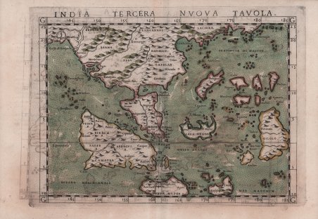
India Tercera nuova tavola
India Tercera nuova tavola | Stampe | RUSCELLI Girolamo
Metodi di Pagamento
- PayPal
- Carta di Credito
- Bonifico Bancario
- Pubblica amministrazione
- Carta del Docente
Dettagli
- Anno di pubblicazione
- 1561
- Luogo di stampa
- Venezia
- Formato
- 265 X 200
- Incisori
- RUSCELLI Girolamo
Descrizione
Importante carta di Girolamo Ruscelli del sud-est asiatico, basata sulla mappa della regione di Giacomo Gastaldi, datata 1548. È una delle prime mappe moderne del sud-est asiatico, ed introduce le scoperte portoghesi della regione. La mappa copre l'area dal Golfo del Bengala alla costa meridionale della Cina, fino a Giava e Timor, ea nord-est di Timor, l'isola di Gilolo. L'istmo di Kra, Malesia e Sumatra hanno tutti una forma strana, con l'istmo che sembra essere molto corto e stretto e la Malesia significativamente più grande di quello reale. Anche Sumatra è presentata in modo impreciso. Sono raffigurate numerose catene montuose e sistemi fluviali e gli oceani, i mari e le baie sono punteggiati. Molti nomi di luoghi sono riconoscibili. Queste raffigurazioni, insieme alle isole vicine e ai primi nomi di luoghi, forniscono un'affascinante visione cinquecentesca della topografia della regione. Acquaforte e bulino, circa 1561. Magnifica prova, impressa su carta vergata coeva, con margini, in perfetto stato di conservazione. Esemplare in meravigliosa coloritura coeva. Carta tratta dalla ' Geographia di Claudio Tolomeo, a cura di Girolamo Ruscelli, pubblicata in Venezia in più edizioni tra il 1561 ed il 1598. La carta è basata sulla “Geografia” di Giacomo Gastaldi (1548), che probabilmente disegnò personalmente anche queste mappe, che vennero incise dai fratelli Livio e Giulio Sanuto. La peculiarità di queste mappe è che sono incise due per lastra e successivamente tagliate; questo il motivo per cui il segno del rame appare solo in tre lati della mappa. Il testo del Ruscelli e le sue carte sono considerate come il miglior atlante moderno fino alla prima versione del ' Theatrum ' ' Orbis Terrarum ' di Abraham Ortelius (1570). Solo la loro larga diffusione ne impedisce una valutazione sostenuta nel mercato antiquario. L'opera infatti ebbe una prima stesura nel 1561, stampata da Vincenzo Valgrisi che ne curò anche la ristampa del 1562. Tre sono le edizioni firmate da Giordano Ziletti (due nel 1564 e una del 1574), mentre nel 1597 viene edita dai fratelli Calignani. Tutte queste edizioni contengono 64 tavole. Nel 1598 e 1599 vengono alla luce le due edizioni curate da Giuseppe Rosaccio e stampate dagli Eredi di Melchior Sessa. Queste ultime due edizioni comprendono 69 tavole; sono infatti aggiunte la carta del planisfero e dei continenti di Rosaccio. Gli esemplari delle carte del Ruscelli in coloritura coeva sono assolutamente rarissimi. Important Ruscelli map of Southeast Asia, based on Gastaldi’s map of the region dated 1548. It is one of the earliest modern maps of Southeast Asia. and one of the earliest to introduce Portuguese discoveries of the region. The map covers the area from the Gulf of Bengal to the southern coast of China, as far south as Java and Timor, and to the northeast of Timor, the island of Gilolo. The Isthmus of Kra, Malaysia and Sumatra are all strangely shaped, with the isthmus appearing to be very short and narrow and Malaysia significantly larger than it is. Sumatra is also inaccurately presented. ' Numerous mountain ranges and river systems are depicted, and the oceans, seas and bays are stippled. Many place names are recognizable. These depictions, along with nearby islands and early place names, provide a fascinating 16th ' century view of the topography of the region. Etching with engraving, about 1561. Magnificent proof, printed on contemporary laid paper, with margins, in perfect condition. Example in wonderful contemporary coloring. Map taken from ' Geographia di Claudio Tolomeo ' edited by Girolamo Ruscelli, published in Venice in several editions between 1561 and 1598. The maps is based on the ' Geografia ' by Giacomo Gastaldi (1548), who probably also personally drew these maps, which were engraved by the brothers Livio and Giulio Sanuto. The peculiarity of these maps is that they are engraved two for plate and subsequently cut; this is why the copper sign only appears on three sides of the map. Ruscelli's text and his maps are considered to be the best modern atlas up to the first version of Abraham Ortelius' ' Theatrum Orbis Terrarum ' (1570). Only their widespread diffusion prevents a sustained evaluation in the antiquarian market. In fact, the work had a first edition in 1561, printed by Vincenzo Valgrisi who also edited the 1562 reprint. There are three editions signed by Giordano Ziletti (two in 1564 and one in 1574), while in 1597 it was published by the Calignani brothers. All these editions contain 64 plates. In 1598 and 1599 the two editions edited by Giuseppe Rosaccio and printed by the heirs of Melchior Sessa came to light. These last two editions include 69 plates; in fact, Rosaccio's map of the planisphere and continents has been added. Example of Ruscelli’s maps in contemporary coloring are absolutely rare. Cfr.
