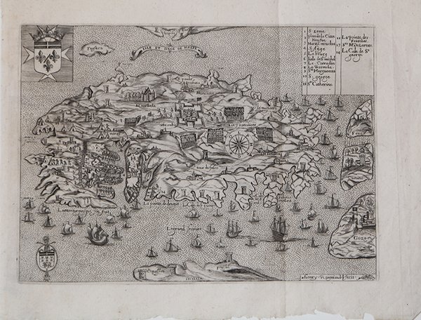
Isle et Siege de Malte
Isle et Siege de Malte | Stampe | RAIGNAULD Henri

Isle et Siege de Malte
Isle et Siege de Malte | Stampe | RAIGNAULD Henri
Metodi di Pagamento
- PayPal
- Carta di Credito
- Bonifico Bancario
- Pubblica amministrazione
- Carta del Docente
Dettagli
- Anno di pubblicazione
- 1629
- Luogo di stampa
- Parigi
- Formato
- 276 X 200
- Incisori
- RAIGNAULD Henri
Descrizione
Rara mappa di Malta e di parte della Sicilia, basata sulla mappa di Matteo Perez d'Aleccio, pubblicata nella rara Histoire des Chevalier de l'Ordre di S. Giovanni di Gerusalemme di J. Badouin, pubblicata a Parigi nel 1629.Quella di Raignauld deriva da due delle più importanti mappe del XVI secolo di Malta,quelle di Antonio Lafreri (1551) e Matteo Perez d'Aleccio.La mappa raffigura Malta al tempo dell'assedio di Malta nel 1565. Dopo la caduta di Costantinopoli nel 1453, i turchi controllavano la regione e si espandevano verso nord in Slovenia e Ungheria, prima di essere fermati a Vienna nel 1529. A quel tempo, la maggior parte il Mediterraneo era fino al controllo musulmano. Malta fu l'ultima roccaforte cristiana nella regione. I Cavalieri di San Giovanni detenevano l'isola fin dal 1530. Difesero l'isola fino al settembre 1565, quando l'assedio terminò, dopo che i rinforzi furono inviati dalla Sicilia.Incisione in rame, in ottime condizioni. Rara. Rare map of Malta and a part of Sicily, based upon Matteo Perez d'Aleccio's map, which appeared in J. Badouin's rare Histoire des Chevaliers de l'Ordre de S. Jean de Jerusalem, published in Paris in 1629.Raignauld's map derives from two of the most important 16th Century maps of Malta, the maps of Antonio Lafreri (1551) and Matteo Perez d'Aleccio.D'Aleccio was an artist who was the official painter for the Order of the Knights of St. John at the time of the successful defense of Malta from Turkish attack in 1565 and was charged with illustrating the defense of the island. He painted a number of frescoes and other works, before leaving Malta in 1581. His map, which began as a painted frescoe, is perhaps the most important and influential depiction of the island at the time of the siege.D'Aleccio's map is one of the most interesting and important maps of Malta. The map was derived from a direct source. However, it is likely that d'Aleccio was influenced by Antonio Lafreri's 1551 Melita Insula . . in his execution of the coastline and basic shape of the island. D'Aleccio's bays and inlets are more pronounced and the coastline is slightly more elaborate. The topographical detail of d'Aleccio's map is significantly better than the Lafreri, showing a fine sharp contrast between hilly terrain, plains and valleys.The map depicts Malta at the time of the Siege of Malta in 1565. After the fall of Constantinopel in 1453, the Turks controlled the region and expanded northward to Slovenia and Hungary, before being halted in Vienna in 1529. By that time, most of the the Mediterranean was until Muslim control. Malta was the last remaining Christian stronghold in the region, prompting its attack in 1564. The Knights of St. John had held the Island since 1530. They defended the island until September 1565, when the Siege ended, after reinforcements were sent from Sicily.Nice example with margins, perfect condition. Rare. Cfr.
